Login
Register


GLD
Renner Field/Goodland Municipal Airport
Official FAA Data Effective 2025-11-27 0901Z
Chart Supplement

KGLD Airport Diagram

VFR Chart of KGLD
Sectional Charts at SkyVector.com
IFR Chart of KGLD
Enroute Charts at SkyVector.com
Location Information for KGLD
Coordinates: N39°22.24' / W101°41.92'Located 02 miles N of Goodland, Kansas on 372 acres of land. View all Airports in Kansas.
Surveyed Elevation is 3657 feet MSL.
Operations Data
|
|
Airport Communications
| ASOS: | 121.025 Tel. 785-576-2383 |
|---|---|
| UNICOM: | 122.800 |
| CTAF: | 122.800 |
| AWOS-3P at SYF (23.7 N): | 118.925 785-306-1050 |
| ASOS at ITR (28.2 W): | 135.225 719-346-7036 |
| AWOS-3P at CBK (30.4 E): | 118.175 785-460-4499 |
- APCH/DEP CTL SVC PRVDD BY DENVER ARTCC (ZDV) ON FREQS 132.7/226.675 (GOODLAND RCAG).
Nearby Navigation Aids
|
| ||||||||||||||||||||||||||||||||||||||||||||||||


Runway 12/30
| Dimensions: | 5499 x 100 feet / 1676 x 30 meters | |
|---|---|---|
| Surface: | Concrete in Good Condition | |
| Weight Limits: | 11 /R/C/X/U, S-30, D-48 | |
| Edge Lighting: | Medium Intensity | |
| Runway 12 | Runway 30 | |
| Coordinates: | N39°22.48' / W101°42.30' | N39°21.85' / W101°41.47' |
| Elevation: | 3645.7 | 3653.4 |
| Traffic Pattern: | Left | Left |
| Runway Heading: | 134° True | 314° True |
| Markings: | Precision Instrument in good condition. | Precision Instrument in good condition. |
| Approach Lights: | MALSR 1,400 Foot Medium-intensity Approach Lighting System with runway alignment indicator lights. | |
| REIL: | Yes | |
| Obstacles: | 30 ft Building 720 ft from runway, 525 ft right of center | |
Runway 05/23
| Dimensions: | 4001 x 75 feet / 1220 x 23 meters | |
|---|---|---|
| Surface: | Concrete in Excellent Condition | |
| Weight Limits: | 5 /F/C/Y/U, S-12 | |
| Edge Lighting: | Medium Intensity | |
| Runway 05 | Runway 23 | |
| Coordinates: | N39°22.11' / W101°42.31' | N39°22.41' / W101°41.55' |
| Elevation: | 3657.6 | 3634.7 |
| Traffic Pattern: | Left | |
| Runway Heading: | 63° True | 243° True |
| Markings: | Non-Precision Instrument in fair condition. | Non-Precision Instrument in fair condition. |
| Glide Slope Indicator | P4L (3.00° Glide Path Angle) PAPI UNUSBL BYD 8 DEGS L OF CNTRLN. | P4L (3.00° Glide Path Angle) |
| Obstacles: | 22 ft Road 625 ft from runway, 270 ft left of center | |
Runway 17/35
| Dimensions: | 1754 x 40 feet / 535 x 12 meters | |
|---|---|---|
| Surface: | Turf in Good Condition | |
| Runway 17 | Runway 35 | |
| Coordinates: | N39°22.60' / W101°42.02' | N39°22.31' / W101°42.02' |
| Elevation: | 3639.6 | 3643.2 |
| Traffic Pattern: | Left | Left |
| Runway Heading: | 180° True | 360° True |
| Markings: | in fair condition. | in fair condition. |
| Obstacles: | 62 ft Pole 378 ft from runway UNMKD 30 FT PLINE, 1300 FT DSTC, ACRS APCH, 43:1. |
|
Services Available
| Fuel: | 100LL (blue), Jet A+ |
|---|---|
| Transient Storage: | Hangars,Tiedowns |
| Airframe Repair: | MAJOR |
| Engine Repair: | MAJOR |
| Bottled Oxygen: | NONE |
| Bulk Oxygen: | LOW |
| Other Services: | CROP DUSTING SERVICES,PILOT INSTRUCTION,AIRCRAFT RENTAL |
Ownership Information
| Ownership: | Publicly owned | |
|---|---|---|
| Owner: | CITY OF GOODLAND | |
| P. O. BOX 59 | ||
| GOODLAND, KS 67735 | ||
| 785-890-4500 | ||
| Manager: | KENT BROWN | CITY/ARPT MGR. |
| 204 W. 11TH ST. | ||
| GOODLAND, KS 67735 | ||
| 785-890-4501 | ||
Other Remarks
- TWY A2 ONLY AVBL FOR ACFT OVER 12500 LBS.
- FOR CD CTC DENVER ARTCC ON FREQ. IF UNA, CTC FSS ON FREQ VIA RCO. IF UNA, CTC DENVER ARTCC AT 303-651-4257.
- TURN-AROUND DOES NOT HAVE CLNC FOR HLDG.
- CALM WIND RWY.
- 3 FT DIA YELLOW CONES MARK THLD.
- 3 FT DIA YELLOW CONES MARK THLD.
- ACTVT MALSR RWY 30; REIL RWY 12; PAPI RWY 05 & 23; MIRL RWY 05/23 & 12/30 - CTAF.
Weather Minimums


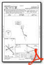
Instrument Approach Procedure (IAP) Charts


Nearby Airports with Instrument Procedures
| ID | Name | Heading / Distance | ||
|---|---|---|---|---|
 |
KSYF | Cheyenne County Municipal Airport | 349° | 23.7 |
|
KITR | Kit Carson County Airport | 254° | 28.4 |
|
KCBK | Shalz Field Airport | 083° | 30.5 |
|
KADT | Atwood-Rawlins County City-County Airport | 047° | 41.5 |
|
KOEL | Oakley Municipal Airport | 110° | 43.9 |
|
2V5 | Wray Municipal Airport | 330° | 50.4 |
|
5K2 | Tribune Municipal Airport | 182° | 55.2 |
|
3K7 | Mark Hoard Memorial Airport | 163° | 57.1 |
|
KOIN | Oberlin Municipal Airport | 062° | 60.5 |
|
2V6 | Yuma Municipal Airport | 313° | 64.4 |
|
KTQK | Scott City Municipal Airport | 144° | 65.9 |
|
KIML | Imperial Municipal Airport | 003° | 68.4 |
Airport Images
Do you have a recent image of this airport? Upload it here!


