
Login
Register


2V6
Yuma Municipal Airport
Official FAA Data Effective 2026-01-22 0901Z
Chart Supplement
VFR Chart of 2V6
Sectional Charts at SkyVector.com
IFR Chart of 2V6
Enroute Charts at SkyVector.com
Location Information for 2V6
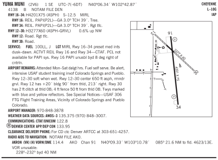
Coordinates: N40°6.34' / W102°42.87'Located 01 miles SE of Yuma, Colorado on 236 acres of land. View all Airports in Colorado.
Surveyed Elevation is 4137 feet MSL.
Operations Data
|
|
Airport Communications
| AWOS-3: | 135.375 Tel. 970-848-3007 |
|---|---|
| CTAF: | 122.800 |
| UNICOM: | 122.800 |
| AWOS-3 at 2V5 (21.7 E): | 118.250 970-332-5930 |
| ASOS at AKO (23.3 W): | 135.475 970-345-2320 |
| AWOS-3 at HEQ (34.4 NE): | 119.275 970-854-3679 |
- APCH/DEP CTL SVC PRVDD BY DENVER ARTCC (ZDV) ON 133.95/317.55 BRUSH/A/ RCAG.
Nearby Navigation Aids
|
| ||||||||||||||||||||||||||||||||||||||||||||||||||||||


Runway 16/34
| Dimensions: | 4201 x 75 feet / 1280 x 23 meters | |
|---|---|---|
| Surface: | Asphalt in Excellent Condition | |
| Weight Limits: | S-12 | |
| Edge Lighting: | Medium Intensity | |
| Runway 16 | Runway 34 | |
| Coordinates: | N40°6.61' / W102°42.92' | N40°5.92' / W102°42.82' |
| Elevation: | 4131.5 | 4133.2 |
| Traffic Pattern: | Right | |
| Runway Heading: | 173° True | 353° True |
| Markings: | Precision Instrument in good condition. | Precision Instrument in good condition. |
| Glide Slope Indicator | P2L (3.00° Glide Path Angle) PAPI UNUSBL BYD 8 DEG RIGHT OF CNTRLN. | P2L (3.00° Glide Path Angle) |
| REIL: | Yes | Yes |
| Obstacles: | 15 ft Tree 740 ft from runway, 85 ft left of center INTERMITTENT +12 FT IRRIGATION PIVOT |
13 ft Other 632 ft from runway, 124 ft left of center |
Runway 12/30
| Dimensions: | 3277 x 60 feet / 999 x 18 meters RWY 12/30 CNTR 650 FT ASPH, RMNDR GRVL. | |
|---|---|---|
| Surface: | Asphalt-Gravel in Good Condition | |
| Runway 12 | Runway 30 | |
| Coordinates: | N40°6.63' / W102°43.12' | N40°6.26' / W102°42.61' |
| Elevation: | 4137.7 | 4117.9 |
| Traffic Pattern: | Right | Left |
| Runway Heading: | 133° True | 313° True |
| Markings: | Basic in good condition. | Basic in good condition. |
| Obstacles: | 18 ft Road 78 ft from runway, 16 ft right of center | 13 ft Road 194 ft from runway |
Services Available
| Fuel: | 100LL (blue), J |
|---|---|
| Transient Storage: | Hangars,Tiedowns |
| Airframe Repair: | NONE |
| Engine Repair: | NONE |
| Bottled Oxygen: | NONE |
| Bulk Oxygen: | NONE |
| Other Services: | CROP DUSTING SERVICES,AIR AMBULANCE SERVICES |
Ownership Information
| Ownership: | Publicly owned | |
|---|---|---|
| Owner: | CITY OF YUMA | |
| 910 S MAIN ST | ||
| YUMA, CO 80759 | ||
| 970-848-3878 | ||
| Manager: | ROBERT MOORE | CITY MANAGER. |
| 321 S. MAIN ST. | ||
| YUMA, CO 80759 | ||
| 970-848-3878 | ||
Other Remarks
- TWYS MKD WITH BLUE & YELLOW REFLECTORS.
- RWY 12/30 SOFT WHEN WET.
- RWY 30 HAS 2 FT DITCH AT THLD 0B; 4 FT FENCE 50 FT FM THLD 0B.
- BE ALERT, INTENSIVE USAF STUDENT TRNG INVOF COLORADO SPRINGS & PUEBLO.
- FOR CD CTC DENVER ARTCC AT 303-651-4257.
- 0LL SELF SERVE
- SELF SERVE
- MIRL RWY 16/34 PRESET MED INTS DUSK-DAWN. ACTVT REIL RWY 16/34 - CTAF. PCL NOT AVBL FOR PAPI SYS.
Weather Minimums

Instrument Approach Procedure (IAP) Charts

Nearby Airports with Instrument Procedures
| ID | Name | Heading / Distance | ||
|---|---|---|---|---|
 |
2V5 | Wray Municipal Airport | 090° | 21.8 |
|
KAKO | Colorado Plains Regional Airport | 280° | 23.7 |
|
KHEQ | Holyoke Airport | 035° | 34.4 |
|
KSTK | Sterling Municipal Airport | 320° | 39.6 |
|
KSYF | Cheyenne County Municipal Airport | 115° | 47.3 |
|
KFMM | Fort Morgan Municipal Airport | 285° | 51.9 |
|
KITR | Kit Carson County Airport | 158° | 55.4 |
|
KIML | Imperial Municipal Airport | 063° | 55.8 |
|
KSNY | Sidney Municipal/Lloyd W Carr Field Airport | 348° | 60.9 |
|
KGGF | Grant Municipal Airport | 044° | 64.2 |
|
KGLD | Renner Field/Goodland Municipal Airport | 132° | 64.4 |
|
KLIC | Limon Municipal Airport | 221° | 66.5 |
Airport Images
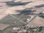
By: 2flaps
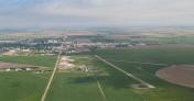
By: brb



Comments
Nice airport close to Yuma,
Nice airport close to Yuma, CO. Paved runway and ramp are in good condition. No fuel. Small pilots and courtesy car. Ag operations in season.