Login
Register


2G2
Geary A Bates/Jefferson County Airpark Airport
Official FAA Data Effective 2025-12-25 0901Z
Chart Supplement

VFR Chart of 2G2
Sectional Charts at SkyVector.com
IFR Chart of 2G2
Enroute Charts at SkyVector.com
Location Information for 2G2
Coordinates: N40°21.64' / W80°42.10'Located 04 miles W of Steubenville, Ohio on 582 acres of land. View all Airports in Ohio.
Surveyed Elevation is 1198 feet MSL.
Operations Data
|
|
Airport Communications
| AWOS-3: | 121.625 Tel. 740-275-4862 |
|---|---|
| PITTSBURGH APPROACH: | 124.75 337.4 338.2 |
| PITTSBURGH DEPARTURE: | 124.75 337.4 338.2 |
| CLASS B: | 337.4 |
| CTAF: | 122.800 |
| UNICOM: | 122.800 |
| ASOS at HLG (11.4 S): | 127.375 304-277-3504 |
| D-ATIS at PIT (22.8 E): | 135.9 ;DEP |
| AWOS-3PT at AFJ (23.2 SE): | 119.175 724-228-3529 |
Nearby Navigation Aids
|
| ||||||||||||||||||||||||||||||||||||||||||||||||||||||||||||


Runway 14/32
| Dimensions: | 5001 x 75 feet / 1524 x 23 meters | |
|---|---|---|
| Surface: | Asphalt in Fair Condition | |
| Weight Limits: | 12 /F/D/X/T, S-31, D-42 | |
| Edge Lighting: | Medium Intensity | |
| Runway 14 | Runway 32 | |
| Coordinates: | N40°21.92' / W80°42.49' | N40°21.35' / W80°41.72' |
| Elevation: | 1198.0 | 1190.5 |
| Traffic Pattern: | Left | Left |
| Runway Heading: | 134° True | 314° True |
| Markings: | Non-Precision Instrument in fair condition. | Non-Precision Instrument in fair condition. |
| Glide Slope Indicator | P4L (3.60° Glide Path Angle) | |
| REIL: | Yes | Yes |
| Obstacles: | 70 ft Trees 1514 ft from runway, 365 ft left of center | |
Services Available
| Fuel: | 100LL (blue), Jet-A, Jet A+ |
|---|---|
| Transient Storage: | Hangars,Tiedowns PPR FOR TSNT HNGR STORAGE. |
| Airframe Repair: | MINOR |
| Engine Repair: | MINOR |
| Bottled Oxygen: | NONE |
| Bulk Oxygen: | NONE |
| Other Services: | AIR AMBULANCE SERVICES,PILOT INSTRUCTION |
Ownership Information
| Ownership: | Publicly owned | |
|---|---|---|
| Owner: | JEFFERSON CO COMMISSIONERS | |
| PO BOX 383 | ||
| STEUBENVILLE, OH 43952-5383 | ||
| 740-283-8500 | ||
| Manager: | BRIAN THAXTON | |
| 600 AIRPARK DR | ||
| WINTERSVILLE, OH 43953-9237 | ||
| 740-264-5388 | ||
Other Remarks
- OCNL DEER, BIRDS, & OTR WILDLIFE ON & INVOF ARPT.
- FOR CD CTC PITTSBURGH APCH AT 412-472-5591.
- 0LL 100LL & JET A AVBL H24 VIA CREDIT CARD.
- ACTVT REIL RWY 14 & 32; MIRL RWY 14/32 - CTAF. PAPI RWY 32 OPR CONSLY.
Weather Minimums
Instrument Approach Procedure (IAP) Charts

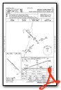
Nearby Airports with Instrument Procedures
| ID | Name | Heading / Distance | ||
|---|---|---|---|---|
 |
KHLG | Wheeling Ohio County Airport | 167° | 11.4 |
|
8G6 | Harrison County Airport | 242° | 16.1 |
|
02G | Columbiana County Airport | 008° | 19.0 |
|
KTSO | Carroll County/Tolson Airport | 305° | 21.0 |
|
KPIT | Pittsburgh International Airport | 069° | 22.9 |
|
KAFJ | Washington County Airport | 125° | 23.2 |
|
KBVI | Beaver County Airport | 029° | 28.5 |
|
KMPG | Marshall County Airport | 183° | 28.8 |
|
6G5 | Barnesville/Bradfield Airport | 226° | 31.1 |
|
G05 | Finleyville Airpark Airport | 102° | 32.5 |
|
KPHD | Harry Clever Field Airport | 281° | 33.6 |
|
KAGC | Allegheny County Airport | 090° | 35.4 |
Airport Images
Do you have a recent image of this airport? Upload it here!


