Login
Register


SCA
Sidney Municipal Airport
Official FAA Data Effective 2026-01-22 0901Z
Chart Supplement

VFR Chart of KSCA
Sectional Charts at SkyVector.com
IFR Chart of KSCA
Enroute Charts at SkyVector.com
Location Information for KSCA
Coordinates: N40°14.48' / W84°8.87'Located 03 miles S of Sidney, Ohio on 83 acres of land. View all Airports in Ohio.
Surveyed Elevation is 1044 feet MSL.
Operations Data
|
|
Airport Communications
| AWOS-3: | 120.425 Tel. 937-492-3683 |
|---|---|
| COLUMBUS APPROACH: | 134.45 294.5 |
| COLUMBUS DEPARTURE: | 134.45 294.5 |
| IC: | 294.5 |
| CTAF: | 123.050 |
| UNICOM: | 123.050 |
| AWOS-3PT at AXV (16.7 NW): | 128.325 419-753-2821 |
| AWOS-3 at EDJ (17.0 NE): | 118.075 937-599-4654 |
| AWOS-3PT at VES (17.9 W): | 125.9 937-526-3154 |
Nearby Navigation Aids
|
| ||||||||||||||||||||||||||||||||||||||||||||||||||||||||||||


Runway 10/28
| Dimensions: | 5013 x 75 feet / 1528 x 23 meters | |
|---|---|---|
| Surface: | Asphalt in Fair Condition | |
| Edge Lighting: | Medium Intensity | |
| Runway 10 | Runway 28 | |
| Coordinates: | N40°14.56' / W84°9.27' | N40°14.50' / W84°8.19' |
| Elevation: | 1039.9 | 1041.4 |
| Traffic Pattern: | Left | Left |
| Runway Heading: | 94° True | 274° True |
| Markings: | Non-Precision Instrument in poor condition. | Non-Precision Instrument in poor condition. |
| Glide Slope Indicator | P2L (3.00° Glide Path Angle) | P2L (3.00° Glide Path Angle) |
| REIL: | Yes | Yes |
| Obstacles: | 7 ft Crops 201 ft from runway, 215 ft left of center TRRN/CROPS IN APCH SFC. 7 FT CROPS, 0-200 FT DIST, 215 FT L. |
15 ft Crops 201 ft from runway, 110 ft right of center 15 FT CROPS ON SLP, 0-200 FT DIST, 110 FT L/R. |
Runway 05/23
| Dimensions: | 2981 x 50 feet / 909 x 15 meters | |
|---|---|---|
| Surface: | Asphalt in Fair Condition | |
| Runway 05 | Runway 23 | |
| Coordinates: | N40°14.20' / W84°9.31' | N40°14.57' / W84°8.90' |
| Elevation: | 1034.8 | 1040.5 |
| Traffic Pattern: | Left | Left |
| Runway Heading: | 40° True | 220° True |
| Markings: | Non-Precision Instrument in fair condition. | Non-Precision Instrument in fair condition. |
| Obstacles: | 8 ft Crops 201 ft from runway 8 FT CROPS AT PAVEMENT END. |
|
Services Available
| Fuel: | 100LL (blue), Jet-A |
|---|---|
| Transient Storage: | Hangars,Tiedowns PRIOR CDN RQRD FOR TSNT HNGR. |
| Airframe Repair: | MAJOR |
| Engine Repair: | MAJOR |
| Bottled Oxygen: | NONE |
| Bulk Oxygen: | HIGH |
| Other Services: | PILOT INSTRUCTION,AIRCRAFT RENTAL |
Ownership Information
| Ownership: | Publicly owned | |
|---|---|---|
| Owner: | CITY OF SIDNEY | |
| 201 W POPLAR ST | ||
| SIDNEY, OH 45365-2720 | ||
| 937-498-2335 | ||
| Manager: | MIKE CHAPPIE | |
| 14833 SIDNEY-PLATTSVILLE RD | ||
| SIDNEY, OH 45365-8772 | ||
| 937-492-9794 | ||
Other Remarks
- FOR CD CTC COLUMBUS APCH AT 614-338-8537.
- FADED EXC RWY NR.
- FADED EXC RWY NR.
- 0LL 100LL & JET A AVBL H24 VIA CREDIT CARD.
- ANTI-ICING ADDITIVE AVBL AT NOZZLE.
- ACTVT REIL RWY 10 & 28; MIRL RWY 10/28 - CTAF. PAPI RWY 10 & 28 OPR CONSLY.
Weather Minimums

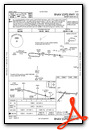
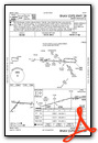
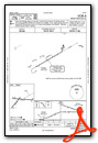
Instrument Approach Procedure (IAP) Charts
Nearby Airports with Instrument Procedures
| ID | Name | Heading / Distance | ||
|---|---|---|---|---|
 |
I17 | Piqua/Hartzell Field Airport | 238° | 8.7 |
|
KAXV | Neil Armstrong Airport | 335° | 16.6 |
|
KEDJ | Bellefontaine Regional Airport | 062° | 17.0 |
|
KVES | Darke County Airport | 262° | 17.8 |
|
I74 | Grimes Field Airport | 109° | 19.2 |
|
KDAY | James M Cox Dayton International Airport | 189° | 20.6 |
|
3I7 | Dayton/Phillipsburg Airport | 210° | 22.8 |
|
KCQA | Lakefield Airport | 307° | 23.8 |
|
KFFO | Wright-Patterson AFB Airport | 169° | 25.3 |
|
KSGH | Springfield/Beckley Municipal Airport | 149° | 27.9 |
|
KAOH | Lima Allen County Airport | 011° | 28.5 |
|
I95 | Hardin County Airport | 046° | 32.0 |
Airport Images
Do you have a recent image of this airport? Upload it here!


