Login
Register


DAY
James M Cox Dayton International Airport
Official FAA Data Effective 2026-02-19 0901Z
Chart Supplement

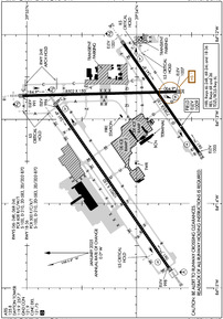
KDAY Airport Diagram
VFR Chart of KDAY
Sectional Charts at SkyVector.com
IFR Chart of KDAY
Enroute Charts at SkyVector.com
Location Information for KDAY
Coordinates: N39°54.14' / W84°13.16'Located 09 miles N of Dayton, Ohio on 4200 acres of land. View all Airports in Ohio.
Surveyed Elevation is 1009 feet MSL.
Operations Data
|
|
Airport Communications
| ATIS: | 125.8 |
|---|---|
| ASOS: | Tel. 937-419-1421 |
| DAYTON TOWER TOWER: | 119.9 257.7 |
| DAYTON TOWER GROUND: | 121.9 |
| COLUMBUS APPROACH: | 118.85 ;091-180 134.45 ;181-090 305.2 ;091-180 323.15 ;181-090 |
| COLUMBUS DEPARTURE: | 118.85 ;091-180 134.45 ;181-090 305.2 ;091-180 323.15 ;181-090 |
| CLEARANCE DELIVERY: | 121.75 |
| EMERG: | 121.5 243.0 |
| DANEI STAR: | 134.45 323.15 |
| CLASS C: | 118.85 ;091-180 134.45 ;181-090 305.2 ;091-180 323.15 ;181-090 |
| UNICOM: | 122.950 |
| ATIS at FFO (9.2 SE): | 269.9 |
| AWOS-3 at GDK (16.4 SE): | 118.525 937-372-4668 |
| AWOS-3PT at SGH (17.7 E): | 134.975 937-324-4532 |
- COMMUNICATIONS PRVDD BY DAYTON RADIO ON FREQS 122.1R/114.5T (DAYTON RCO).
Nearby Navigation Aids
|
| ||||||||||||||||||||||||||||||||||||||||||||||||||||||||||||


Runway 06L/24R
| Dimensions: | 10901 x 150 feet / 3323 x 46 meters | |
|---|---|---|
| Surface: | Asphalt-Concrete / Grooved in Good Condition NE 1400 FT CONC, SW 9501 FT ASPH. | |
| Weight Limits: | S-100, D-210, ST-583, DT-870
PCR VALUE: 608/R/C/W/T
| |
| Edge Lighting: | High Intensity | |
| Runway 06L | Runway 24R | |
| Coordinates: | N39°53.71' / W84°14.76' | N39°54.73' / W84°12.84' |
| Elevation: | 997.9 | 995.6 |
| Traffic Pattern: | Left | Left |
| Runway Heading: | 55° True | 235° True |
| Declared Distances: | TORA:10900 TODA:10900 ASDA:10900 LDA:10900 | TORA:10900 TODA:10900 ASDA:10900 LDA:10900 |
| Markings: | Precision Instrument in good condition. | Precision Instrument in good condition. |
| Glide Slope Indicator | P4L (3.00° Glide Path Angle) | P4L (3.00° Glide Path Angle) |
| RVR Equipment | Touchdown Midfield Rollout | Touchdown Midfield Rollout |
| Approach Lights: | ALSF2 Standard 2,400 Foot High-intensity Approach Lighting System with sequenced flashers, CATEGORY II or III Configuration. | MALSR 1,400 Foot Medium-intensity Approach Lighting System with runway alignment indicator lights. |
| Centerline Lights: | Yes | Yes |
| Obstacles: | 75 ft Tree 3417 ft from runway, 197 ft right of center | |
Runway 18/36
| Dimensions: | 8502 x 150 feet / 2591 x 46 meters | |
|---|---|---|
| Surface: | Asphalt / Grooved in Good Condition | |
| Weight Limits: | S-100, D-210, ST-583, DT-870
PCR VALUE: 500/F/C/X/T
| |
| Edge Lighting: | High Intensity | |
| Runway 18 | Runway 36 | |
| Coordinates: | N39°55.04' / W84°12.72' | N39°53.64' / W84°12.68' |
| Elevation: | 990.7 | 1007.2 |
| Traffic Pattern: | Left | Left |
| Runway Heading: | 179° True | 359° True |
| Declared Distances: | TORA:8502 TODA:8502 ASDA:8502 LDA:8502 | TORA:8502 TODA:8502 ASDA:8502 LDA:8502 |
| Markings: | Precision Instrument in good condition. | Precision Instrument in good condition. |
| Glide Slope Indicator | P4L (3.00° Glide Path Angle) | |
| RVR Equipment | Touchdown | |
| Approach Lights: | MALSR 1,400 Foot Medium-intensity Approach Lighting System with runway alignment indicator lights. | |
| REIL: | Yes | |
| Obstacles: | 56 ft Trees 2636 ft from runway, 185 ft right of center | 41 ft Trees 1050 ft from runway |
Runway 06R/24L
| Dimensions: | 7285 x 150 feet / 2220 x 46 meters | |
|---|---|---|
| Surface: | Concrete / Grooved in Good Condition | |
| Weight Limits: | S-100, D-210, ST-583, DT-870
PCR VALUE: 608/R/C/W/T
| |
| Edge Lighting: | High Intensity | |
| Runway 06R | Runway 24L | |
| Coordinates: | N39°53.43' / W84°13.39' | N39°54.12' / W84°12.11' |
| Elevation: | 1005.0 | 1001.1 |
| Traffic Pattern: | Left | Left |
| Runway Heading: | 55° True | 235° True |
| Declared Distances: | TORA:7285 TODA:7285 ASDA:7001 LDA:7001 | TORA:7285 TODA:7285 ASDA:7001 LDA:7001 |
| Markings: | Precision Instrument in good condition. | Precision Instrument in good condition. |
| Glide Slope Indicator | P4L (3.00° Glide Path Angle) | P4L (3.00° Glide Path Angle) |
| RVR Equipment | Touchdown | |
| Approach Lights: | MALSR 1,400 Foot Medium-intensity Approach Lighting System with runway alignment indicator lights. | |
| REIL: | Yes | |
| Obstacles: | 51 ft Tree 1230 ft from runway, 517 ft right of center | 25 ft Pole 1194 ft from runway, 633 ft right of center |
Services Available
| Fuel: | 100 (green), Jet-A |
|---|---|
| Transient Storage: | Hangars |
| Airframe Repair: | MAJOR |
| Engine Repair: | MAJOR |
| Bottled Oxygen: | NONE |
| Bulk Oxygen: | HIGH |
| Other Services: | AIR FREIGHT SERVICES,AVIONICS,CARGO HANDLING SERVICES,CHARTER SERVICE,PILOT INSTRUCTION,AIRCRAFT RENTAL,AIRCRAFT SALES |
Ownership Information
| Ownership: | Publicly owned | |
|---|---|---|
| Owner: | CITY OF DAYTON, OHIO | |
| 101 W 3RD ST | ||
| DAYTON, OH 45402-1859 | ||
| 937-333-3333 | ||
| Manager: | DANIEL J ZENK | |
| 3600 TERMINAL DR STE 300 | ||
| VANDALIA, OH 45377-1095 | ||
| 937-454-8212 | ||
Other Remarks
- SNC RAMP NORTH OF RWY 06L/24R EDGE LGTS NSTD.
- TWY W SIGN LGTS OTS.
- RUNUPS PROHIBITED ON RWY 24L HOLD PAD.
- TWY Z, TWY T, & TWY S BTN RWY 06L/24R & TWY W CLSD INDEFLY.
- DEER, COYOTES, BIRDS, & WATERFOWL ON & INVOF ARPT.
- TWY C BTN TWY N & TWY Z NOT AVBL FOR GROUP IV & GTR ACFT. TWY K, TWY H, TWY J, & TWY L NOT AVBL FOR GROUP IV & GTR ACFT.
- TWY M NORTH OF RWY 06L/24R & TWY W CLSD TO ACR ACFT; ALL OTR ACFT 24 HR PPR 937-454-2010.
- TWY M NORTH OF RWY 06L/24R & TWY W EDGE LGTS NSTD.
Weather Minimums

Standard Terminal Arrival (STAR) Charts

Instrument Approach Procedure (IAP) Charts

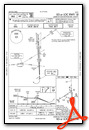
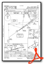
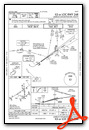


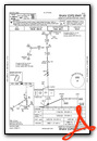

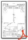


Departure Procedure (DP) Charts


Nearby Airports with Instrument Procedures
| ID | Name | Heading / Distance | ||
|---|---|---|---|---|
 |
3I7 | Dayton/Phillipsburg Airport | 274° | 8.4 |
|
KFFO | Wright-Patterson AFB Airport | 119° | 9.2 |
|
I73 | Moraine Air Park Airport | 184° | 13.2 |
|
I17 | Piqua/Hartzell Field Airport | 345° | 16.3 |
|
KGDK | Greene County/Lewis A Jackson Regional Airport | 140° | 16.5 |
|
KSGH | Springfield/Beckley Municipal Airport | 101° | 17.9 |
|
KMGY | Dayton/Wright Brothers Airport | 180° | 18.8 |
|
KSCA | Sidney Municipal Airport | 009° | 20.6 |
|
KVES | Darke County Airport | 321° | 23.2 |
|
KMWO | Middletown Regional/Hook Field Airport | 200° | 23.7 |
|
I74 | Grimes Field Airport | 057° | 25.5 |
|
I68 | Warren County/John Lane Field Airport | 183° | 26.4 |
Fuel Providers

Airport Images
 from the east")
By: keeganm


