Login
Register


MHK
Manhattan Regional Airport
Official FAA Data Effective 2026-01-22 0901Z
Chart Supplement

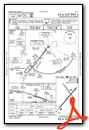
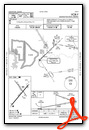
KMHK Airport Diagram

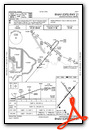
VFR Chart of KMHK
Sectional Charts at SkyVector.com
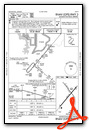
IFR Chart of KMHK
Enroute Charts at SkyVector.com
Location Information for KMHK
Coordinates: N39°8.49' / W96°40.29'Located 04 miles SW of Manhattan, Kansas on 680 acres of land. View all Airports in Kansas.
Surveyed Elevation is 1066 feet MSL.
TPA: LIGHT ACFT 843 AGL; TURBINE ACFT 1443 FT AGL.
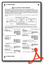
Operations Data
|
|
Airport Communications
| ASOS: | 119.075 Tel. 785-537-1035 |
|---|---|
| MANHATTAN TOWER: | 118.55 |
| MANHATTAN GROUND: | 121.85 |
| MARSHALL AAF GCA APPROACH: | 121.25 269.05 |
| MARSHALL AAF GCA DEPARTURE: | 121.25 269.05 |
| CTAF: | 118.550 |
| ASOS at FRI (6.9 SW): | |
| ATIS at FRI (6.9 SW): | 121.025 |
| AWOS-3T at CYW (27.0 NW): | 119.95 785-777-2507 |
- APCH/DEP CTL SVC PRVDD BY KANSAS CITY ARTCC (ZKC) ON FREQS 127.35/257.975 (MANHATTAN RCAG) WHEN MARSHALL APCH CTL (FRI) CLSD.
Nearby Navigation Aids
|
| ||||||||||||||||||||||||||||||||||||||||||||||||||||||||||||


Runway 03/21
| Dimensions: | 7400 x 150 feet / 2256 x 46 meters | |
|---|---|---|
| Surface: | Concrete / Grooved in Good Condition | |
| Weight Limits: | S-120, D-195, ST-339
PCR VALUE: 640/R/C/W/T
| |
| Edge Lighting: | High Intensity | |
| Runway 03 | Runway 21 | |
| Coordinates: | N39°7.89' / W96°40.81' | N39°8.83' / W96°39.81' |
| Elevation: | 1057.0 | 1044.1 |
| Traffic Pattern: | Right | Left |
| Runway Heading: | 40° True | 220° True |
| Displaced Threshold: | 370 Feet | |
| Declared Distances: | TORA:7030 TODA:7030 ASDA:7030 LDA:7030 | TORA:7400 TODA:7400 ASDA:7400 LDA:7030 |
| Markings: | Precision Instrument in good condition. | Precision Instrument in good condition. |
| Glide Slope Indicator | P4L (3.00° Glide Path Angle) | P4L (3.00° Glide Path Angle) |
| Approach Lights: | MALSR 1,400 Foot Medium-intensity Approach Lighting System with runway alignment indicator lights. | |
| REIL: | Yes | |
| Obstacles: | 105 ft Trees 3996 ft from runway, 537 ft left of center | 86 ft Trees 2124 ft from runway, 259 ft right of center |
Runway 13/31
RWY 13/31 NOT AVBL FOR PART 121/PART 380 OPS WITH SKED PAX CARRYING OPS MORE THAN 9 PAX SEATS AND NON-SKED PAX CARRYING OPS MORE THAN 30 PAX SEATS. | ||
| Dimensions: | 5001 x 75 feet / 1524 x 23 meters | |
|---|---|---|
| Surface: | Asphalt-Concrete in Excellent Condition | |
| Weight Limits: | S-30, D-39
PCR VALUE: 150/R/C/W/T
| |
| Edge Lighting: | Medium Intensity | |
| Runway 13 | Runway 31 | |
| Coordinates: | N39°8.99' / W96°40.59' | N39°8.34' / W96°39.94' |
| Elevation: | 1066.1 | 1051.2 |
| Traffic Pattern: | Left | Right |
| Runway Heading: | 142° True | 322° True |
| Declared Distances: | TORA:5000 TODA:5000 ASDA:5000 LDA:5000 | TORA:5000 TODA:5000 ASDA:5000 LDA:5000 |
| Markings: | Basic in good condition. | Basic in good condition. |
| Glide Slope Indicator | V2L (3.50° Glide Path Angle) | P4L (3.00° Glide Path Angle) |
| REIL: | Yes | |
| Obstacles: | 237 ft Pole 7174 ft from runway, 392 ft left of center | 93 ft Tree 1607 ft from runway, 624 ft left of center |
Services Available
| Fuel: | 100LL (blue), Jet-A |
|---|---|
| Transient Storage: | Hangars,Tiedowns |
| Airframe Repair: | MAJOR |
| Engine Repair: | MAJOR |
| Bottled Oxygen: | NOT AVAILABLE |
| Bulk Oxygen: | NOT AVAILABLE |
| Other Services: | AIR AMBULANCE SERVICES,CARGO HANDLING SERVICES,CHARTER SERVICE,PILOT INSTRUCTION,AIRCRAFT RENTAL,AIRCRAFT SALES,ANNUAL SURVEYING |
Ownership Information
| Ownership: | Publicly owned | |
|---|---|---|
| Owner: | CITY OF MANHATTAN | |
| 1101 POYNTZ | ||
| MANHATTAN, KS 66502-5497 | ||
| 785-587-4560 | ||
| Manager: | BRANDON KEAZER | |
| 5500 SKYWAY DRIVE, STE 120 | ||
| MANHATTAN, KS 66503-9791 | ||
| 785-587-4565 | AFT HR - 785-587-4562. | |
Other Remarks
- 24 HR PPR FOR UNSKED ACR GTR THAN 30 PAX SEATS - 785-587-4597.
- FOR CD IF UNA CTC ON FSS FREQ, CTC MARSHALL APCH AS 785-239-2118. WHEN MARSHALL APCH IS CLSD, CTC KANSAS CITY ARTCC AT 913-254-8508.
- NONSTD ATC MINIMA APPLIED TO IFR HIGH PERFORMANCE OPS ARR WI CFNS OF R-3602.
- MIL ARPT 7 MI SW RESEMBLES THIS ARPT.
- BIRDS INVOF ARPT MAR-MAY & SEP-NOV; WILDLIFE ON & INVOF RWYS.
- WHEN ATCT CLSD ACTVT MALSR RWY 03; REIL RWY 21 & 31; HIRL RWY 03/21; MIRL RWY 13/31 - CTAF. PAPI RWY 03, 21 & 31; VASI RWY 13; OPR CONSLY.
- MULTICOM FREQ 122.85 AVBL.
- TPA: LIGHT ACFT 843 AGL; TURBINE ACFT 1443 FT AGL.
Weather Minimums

Instrument Approach Procedure (IAP) Charts

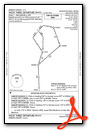
Departure Procedure (DP) Charts
Nearby Airports with Instrument Procedures
| ID | Name | Heading / Distance | ||
|---|---|---|---|---|
 |
3JC | Freeman Field Airport | 233° | 9.9 |
|
KCYW | Clay Center Municipal Airport | 303° | 27.0 |
|
KHRU | Herington Regional Airport | 193° | 27.5 |
|
K78 | Abilene Municipal Airport | 241° | 30.0 |
|
K38 | Washington County Veteran's Memorial Airport | 333° | 39.7 |
|
KMYZ | Marysville Municipal Airport | 002° | 42.9 |
|
KFOE | Topeka Regional Airport | 103° | 48.5 |
|
KTOP | Philip Billard Municipal Airport | 094° | 49.2 |
|
KSLN | Salina Regional Airport | 245° | 50.5 |
|
KCNK | Blosser Municipal Airport | 298° | 51.8 |
|
KEMP | Emporia Municipal Airport | 154° | 53.6 |
|
KRPB | Belleville Municipal Airport | 311° | 61.2 |
Airport Images
Do you have a recent image of this airport? Upload it here!


