Login
Register


BAX
Huron County Memorial Airport
Official FAA Data Effective 2025-12-25 0901Z
Chart Supplement

VFR Chart of KBAX
Sectional Charts at SkyVector.com
IFR Chart of KBAX
Enroute Charts at SkyVector.com
Location Information for KBAX
Coordinates: N43°46.81' / W82°59.13'Located 01 miles S of Bad Axe, Michigan on 386 acres of land. View all Airports in Michigan.
Surveyed Elevation is 763 feet MSL.
Operations Data
|
|
Airport Communications
| AWOS-3: | 118.6 Tel. 989-269-4137 |
|---|---|
| UNICOM: | 123.075 |
| CTAF: | 123.075 |
| AWOS-3 at CFS (27.8 SW): | 119.275 989-672-4182 |
| AWOS-3PT at HYX (43.6 SW): | 118.325 989-752-3408 |
| AWOS-3P at OSC (44.0 N): | 118.7 989-739-1310 |
- APCH/DEP SVC PRVDD BY CLEVELAND ARTCC (ZOB) ON FREQS 127.7/290.425 (FREELAND RCAG).
Nearby Navigation Aids
|
| ||||||||||||||||||||||||||||||||||||||||||||||||


Runway 17/35
| Dimensions: | 5000 x 75 feet / 1524 x 23 meters | |
|---|---|---|
| Surface: | Asphalt / Grooved in Excellent Condition | |
| Weight Limits: | 19 /F/C/X/T | |
| Edge Lighting: | Medium Intensity | |
| Runway 17 | Runway 35 | |
| Coordinates: | N43°47.10' / W82°59.25' | N43°46.31' / W82°58.95' |
| Elevation: | 763.3 | 753.6 |
| Runway Heading: | 165° True | 345° True |
| Markings: | Non-Precision Instrument in good condition. | Non-Precision Instrument in good condition. |
| Glide Slope Indicator | P4L (3.00° Glide Path Angle) | P4L (3.00° Glide Path Angle) |
| REIL: | Yes | Yes |
| Obstacles: | 56 ft Trees 1349 ft from runway, 250 ft left of center | |
Runway 04/22
| Dimensions: | 3495 x 75 feet / 1065 x 23 meters | |
|---|---|---|
| Surface: | Asphalt in Good Condition | |
| Weight Limits: | S-16 | |
| Edge Lighting: | Medium Intensity | |
| Runway 04 | Runway 22 | |
| Coordinates: | N43°46.72' / W82°59.34' | N43°47.22' / W82°58.97' |
| Elevation: | 755.1 | 762.6 |
| Traffic Pattern: | Left | Left |
| Runway Heading: | 28° True | 208° True |
| Displaced Threshold: | 300 Feet | |
| Markings: | Non-Precision Instrument in good condition. | Non-Precision Instrument in good condition. |
| Glide Slope Indicator | P4L (3.00° Glide Path Angle) | P4L (3.50° Glide Path Angle) |
| Obstacles: | 21 ft Railroad 266 ft from runway, 260 ft left of center APCH SLP 20:1 TO DTHR. |
51 ft Trees 716 ft from runway, 348 ft left of center |
Services Available
| Fuel: | 100LL (blue), Jet A+ |
|---|---|
| Transient Storage: | Tiedowns |
| Airframe Repair: | NOT AVAILABLE |
| Engine Repair: | NOT AVAILABLE |
| Bottled Oxygen: | NOT AVAILABLE |
| Bulk Oxygen: | NOT AVAILABLE |
Ownership Information
| Ownership: | Publicly owned | |
|---|---|---|
| Owner: | COUNTY OF HURON | |
| 417 S HANSELMAN ST | ||
| BAD AXE, MI 48413-1446 | ||
| 989-269-6404 | ||
| Manager: | CHRIS JACKSON | |
| 352 THOMPSON RD | ||
| BAD AXE, MI 48413-9491 | ||
| 989-269-6511 | ||
Other Remarks
- DEER & LRG BIRDS ON & INVOF ARPT.
- ADMIN BLDG ACES: PRESS V, THEN III & II SIMUL, THEN I.
- TURBO PROP & JET LANDING FEE WAIVED WITH FUEL PURCHASE.
- FOR CD CTC CLEVELAND ARTCC AT 440-774-0224/0490.
- MIRL RYS 04/22 & 17/35 OPER DUSK-2130; TO INCR INTST & AFT 2130 ACTVT - CTAF. ACTVT PAPI RYS 4, 17, 22, & 35 AND REIL RYS 17 & 35 - CTAF.
Weather Minimums

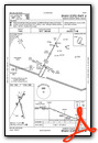
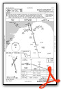
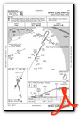
Instrument Approach Procedure (IAP) Charts

Nearby Airports with Instrument Procedures
| ID | Name | Heading / Distance | ||
|---|---|---|---|---|
 |
Y83 | Sandusky City Airport | 162° | 20.5 |
|
KCFS | Tuscola Area Airport | 226° | 27.8 |
|
77G | Marlette Township Airport | 189° | 28.5 |
|
6D9 | Iosco County Airport | 329° | 37.1 |
|
3CM | James Clements Municipal Airport | 250° | 42.0 |
|
KHYX | Saginaw County/H W Browne Airport | 241° | 43.5 |
|
KOSC | Oscoda/Wurtsmith Airport | 336° | 44.0 |
|
D95 | Dupont/Lapeer Airport | 196° | 44.6 |
|
KMBS | Mbs International Airport | 253° | 49.9 |
|
CYZR | Sarnia Chris Hadfield Airport | 147° | 55.4 |
|
KIKW | Jack Barstow Airport | 263° | 56.0 |
|
KPHN | St Clair County International Airport | 158° | 55.8 |
Airport Images
Do you have a recent image of this airport? Upload it here!


