Login
Register


PHN
St Clair County International Airport
Official FAA Data Effective 2025-12-25 0901Z
Chart Supplement

VFR Chart of KPHN
Sectional Charts at SkyVector.com
IFR Chart of KPHN
Enroute Charts at SkyVector.com
Location Information for KPHN
Coordinates: N42°54.66' / W82°31.73'Located 05 miles SW of Port Huron, Michigan on 1135 acres of land. View all Airports in Michigan.
Surveyed Elevation is 650 feet MSL.
Operations Data
|
|
Airport Communications
| AWOS-3: | 118.375 Tel. 810-364-7787 |
|---|---|
| SELFRIDGE APPROACH: | 119.6 391.9 |
| SELFRIDGE DEPARTURE: | 119.6 391.9 |
| CTAF: | 123.050 |
| UNICOM: | 123.050 |
| ATIS at MTC (22.4 SW): | 125.325 |
| AWOS-3P at D95 (33.9 W): | 134.050 810-664-5038 |
| AWOS-3 at VLL (36.2 SW): | 119.475 248-288-4649 |
- APCH/DEP SVC PRVDD BY CLEVELAND ARTCC (ZOB) ON FREQS 126.525/285.525 (ALGONAC RCAG) WHEN SELFRIDGE APCH CTL CLSD.
Nearby Navigation Aids
|
| ||||||||||||||||||||||||||||||||||||||||||


Runway 04/22
| Dimensions: | 5104 x 100 feet / 1556 x 30 meters | |
|---|---|---|
| Surface: | Asphalt / Grooved in Good Condition | |
| Weight Limits: | S-40, D-55, ST-90 | |
| Edge Lighting: | High Intensity | |
| Runway 04 | Runway 22 | |
| Coordinates: | N42°54.28' / W82°32.12' | N42°54.96' / W82°31.44' |
| Elevation: | 639.8 | 649.5 |
| Traffic Pattern: | Left | Left |
| Runway Heading: | 36° True | 216° True |
| Markings: | Precision Instrument in good condition. | Precision Instrument in good condition. |
| Glide Slope Indicator | P4L (3.00° Glide Path Angle) | P4L (3.00° Glide Path Angle) |
| Approach Lights: | MALSR 1,400 Foot Medium-intensity Approach Lighting System with runway alignment indicator lights. | |
| REIL: | Yes | |
| Obstacles: | 49 ft Tree 592 ft from runway, 573 ft left of center | 76 ft Tree 1870 ft from runway, 78 ft right of center |
Runway 10/28
| Dimensions: | 4000 x 75 feet / 1219 x 23 meters | |
|---|---|---|
| Surface: | Asphalt in Good Condition | |
| Weight Limits: | S-16 | |
| Edge Lighting: | Medium Intensity | |
| Runway 10 | Runway 28 | |
| Coordinates: | N42°54.74' / W82°32.11' | N42°54.68' / W82°31.22' |
| Elevation: | 643.1 | 650.1 |
| Traffic Pattern: | Left | Left |
| Runway Heading: | 95° True | 275° True |
| Markings: | Non-Precision Instrument in fair condition. | Non-Precision Instrument in fair condition. |
| Glide Slope Indicator | P4L (3.00° Glide Path Angle) | P4L (3.50° Glide Path Angle) |
| REIL: | Yes | Yes |
| Obstacles: | 71 ft Tree 1386 ft from runway, 250 ft left of center | 57 ft Tree 1173 ft from runway, 35 ft right of center |
Services Available
| Fuel: | 100LL (blue), Jet A+ |
|---|---|
| Transient Storage: | Hangars,Tiedowns |
| Airframe Repair: | MAJOR |
| Engine Repair: | MAJOR |
| Bottled Oxygen: | NONE |
| Bulk Oxygen: | NONE |
Ownership Information
| Ownership: | Publicly owned | |
|---|---|---|
| Owner: | SAINT CLAIR COUNTY | |
| 201 MCMORRAN BLVD | ||
| PORT HURON, MI 48060-4006 | ||
| 810-364-6890 | ||
| Manager: | CATHERINE FIORE | |
| 177 ASH DR | ||
| KIMBALL, MI 48074-4403 | ||
| 810-364-6890 | ||
Other Remarks
- DEER & LRG BIRDS ON & INVOF ARPT.
- TSATLC FLTS MUST NTFY US CUST AT 810-985-9541 ONE HR PRIOR TO ENTRY INTO THE US. NTFY US DEPT OF AGRICULTURE AT 810-985-6126 & AMGR 24 HRS PRIOR FOR DISPOSAL OF ACFT INTL TRASH.
- FOR CD CTC SELFRIDGE APCH AT 586-239-5706, WHEN APCH CLSD CTC CLEVELAND ARTCC AT 440-774-0224/0490.
- ACTVT MALSR RWY 04; REIL RWY 22, 10, & 28; PAPI RWY 10 & 28; HIRL RWY 04/22; MIRL RWY 10/28 - CTAF. PAPI RWY 04 & 22 OPR CONSLY.
Weather Minimums

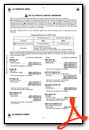
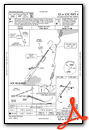
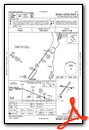
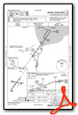
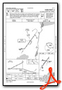
Instrument Approach Procedure (IAP) Charts
Nearby Airports with Instrument Procedures
| ID | Name | Heading / Distance | ||
|---|---|---|---|---|
 |
CYZR | Sarnia Chris Hadfield Airport | 061° | 11.0 |
|
57D | Ray Community Airport | 236° | 19.0 |
|
D98 | Romeo State Airport | 250° | 20.8 |
|
KMTC | Selfridge Angb Airport | 217° | 22.4 |
|
D95 | Dupont/Lapeer Airport | 286° | 34.0 |
|
77G | Marlette Township Airport | 314° | 34.5 |
|
Y83 | Sandusky City Airport | 337° | 35.4 |
|
KVLL | Oakland/Troy Airport | 232° | 36.2 |
|
KDET | Coleman A Young Municipal Airport | 215° | 36.7 |
|
KPTK | Oakland County International Airport | 249° | 42.1 |
|
CYQG | Windsor Airport | 206° | 42.6 |
|
KCFS | Tuscola Area Airport | 309° | 52.0 |
Airport Images

By: Ton Phanan
 - 4 Final Approach - 2017-09-10")
By: Ton Phanan


