Login
Register


CBK
Shalz Field Airport
Official FAA Data Effective 2026-02-19 0901Z
Chart Supplement

KCBK Airport Diagram

VFR Chart of KCBK
Sectional Charts at SkyVector.com
IFR Chart of KCBK
Enroute Charts at SkyVector.com
Location Information for KCBK
Coordinates: N39°25.65' / W101°2.80'Located 02 miles N of Colby, Kansas on 473 acres of land. View all Airports in Kansas.
Surveyed Elevation is 3188 feet MSL.
Operations Data
|
|
Airport Communications
| AWOS-3P: | 118.175 Tel. 785-460-4499 |
|---|---|
| UNICOM: | 122.800 |
| CTAF: | 122.800 |
| AWOS-3 at OEL (21.6 SE): | 118.325 785-671-4194 |
| AWOS-3 at ADT (24.8 N): | 118.675 785-626-3572 |
| ASOS at GLD (30.2 W): | 121.025 785-576-2383 |
- APCH/DEP CTL SVC PRVDD BY DENVER ARTCC (ZDV) ON FREQS 132.7/226.675 (GOODLAND RCAG).
Nearby Navigation Aids
|
| ||||||||||||||||||||||||||||||||||||||||||||||||||||||||||||


Runway 17/35
| Dimensions: | 5110 x 75 feet / 1558 x 23 meters | |
|---|---|---|
| Surface: | Concrete / Aggregate Friction Seal Coated in Fair Condition | |
| Weight Limits: | S-30, D-38 | |
| Edge Lighting: | Medium Intensity | |
| Runway 17 | Runway 35 | |
| Coordinates: | N39°26.12' / W101°2.90' | N39°25.27' / W101°2.90' |
| Elevation: | 3188.2 | 3155.1 |
| Traffic Pattern: | Left | Left |
| Runway Heading: | 180° True | 0 |
| Markings: | Non-Precision Instrument in fair condition. | Non-Precision Instrument in fair condition. |
| Glide Slope Indicator | P4L (3.00° Glide Path Angle) | P4L (3.00° Glide Path Angle) |
| REIL: | Yes | Yes |
Runway 12/30
| Dimensions: | 2660 x 90 feet / 811 x 27 meters | |
|---|---|---|
| Surface: | Turf in Good Condition | |
| Runway 12 | Runway 30 | |
| Coordinates: | N39°25.70' / W101°2.89' | N39°25.39' / W101°2.50' |
| Elevation: | 3170.2 | 3152.8 |
| Traffic Pattern: | Left | Left |
| Runway Heading: | 135° True | 315° True |
| Obstacles: | 22 ft Tree 420 ft from runway, 125 ft right of center | |
Runway 04/22
| Dimensions: | 2600 x 80 feet / 792 x 24 meters | |
|---|---|---|
| Surface: | Turf in Good Condition | |
| Runway 04 | Runway 22 | |
| Coordinates: | N39°25.51' / W101°2.89' | N39°25.81' / W101°2.50' |
| Elevation: | 3162.3 | 3170.7 |
| Traffic Pattern: | Left | Left |
| Runway Heading: | 46° True | 226° True |
Services Available
| Fuel: | 100LL (blue), Jet A-1+ |
|---|---|
| Transient Storage: | Hangars,Tiedowns |
| Airframe Repair: | MAJOR |
| Engine Repair: | MAJOR |
| Bottled Oxygen: | NONE |
| Bulk Oxygen: | NONE |
| Other Services: | CROP DUSTING SERVICES,PILOT INSTRUCTION,AIRCRAFT RENTAL |
Ownership Information
| Ownership: | Publicly owned | |
|---|---|---|
| Owner: | CITY OF COLBY | |
| 585 N. FRANKLIN | ||
| COLBY, KS 67701 | ||
| 785-460-4410 | ||
| Manager: | DUSTIN STEPHENSON | |
| 5 ARPT PLAZA | ||
| COLBY, KS 67701 | ||
| 785-460-4438 | ||
Other Remarks
- SEASONAL AG OPERATIONS
- FOR CD CTC DENVER ARTCC AT 303-651-4257.
- FOR SVC CALL (785) 460-4438/460-3298.
- ACTVT REIL RWY 17 & 35; PAPI RWY 17 & 35; MIRL RWY 17/35- CTAF.
Weather Minimums


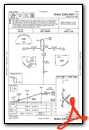
Instrument Approach Procedure (IAP) Charts

Nearby Airports with Instrument Procedures
| ID | Name | Heading / Distance | ||
|---|---|---|---|---|
 |
KOEL | Oakley Municipal Airport | 150° | 21.7 |
|
KADT | Atwood-Rawlins County City-County Airport | 000° | 24.8 |
|
KGLD | Renner Field/Goodland Municipal Airport | 263° | 30.5 |
|
KOIN | Oberlin Municipal Airport | 043° | 33.9 |
|
KSYF | Cheyenne County Municipal Airport | 300° | 40.0 |
|
1QK | Gove County Airport | 121° | 44.5 |
|
KMCK | Mc Cook Ben Nelson Regional Airport | 024° | 51.2 |
|
KHLC | Hill City Municipal Airport | 092° | 56.6 |
|
KTQK | Scott City Municipal Airport | 172° | 57.6 |
|
KITR | Kit Carson County Airport | 259° | 58.7 |
|
KNRN | Norton Municipal Airport | 064° | 59.1 |
|
0H1 | Trego Wakeeney Airport | 114° | 59.4 |
Airport Images
Do you have a recent image of this airport? Upload it here!


