Login
Register
FEP
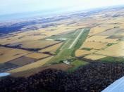
Albertus Airport
Official FAA Data Effective 2025-11-27 0901Z
VFR Chart of KFEP
Sectional Charts at SkyVector.com
IFR Chart of KFEP
Enroute Charts at SkyVector.com
Location Information for KFEP
Coordinates: N42°14.77' / W89°34.92'Located 03 miles SE of Freeport, Illinois on 188 acres of land. View all Airports in Illinois.
Surveyed Elevation is 859 feet MSL.
TPA: 400 FT AGL ULTRALIGHTS, 800 FT AGL PISTON ACFT.
Operations Data
|
|
Airport Communications
| AWOS-3: | 120.525 Tel. 815-233-4472 |
|---|---|
| ROCKFORD APPROACH: | 126.0 327.0 |
| ROCKFORD DEPARTURE: | 126.0 327.0 |
| CLEARANCE DELIVERY: | 121.85 |
| CTAF: | 122.800 |
| UNICOM: | 122.800 |
| ASOS at RFD (21.8 E): | 224-634-4737 |
| ATIS at RFD (21.8 E): | 127.6 |
| AWOS-3 at EFT (22.2 N): | 118.375 608-328-8359 |
Nearby Navigation Aids
|
| ||||||||||||||||||||||||||||||||||||||||||||||||
Runway 06/24
| Dimensions: | 5504 x 100 feet / 1678 x 30 meters | |
|---|---|---|
| Surface: | Asphalt / Grooved in Good Condition | |
| Weight Limits: | S-20, D-60 | |
| Edge Lighting: | Medium Intensity | |
| Runway 06 | Runway 24 | |
| Coordinates: | N42°14.40' / W89°35.41' | N42°14.93' / W89°34.42' |
| Elevation: | 859.0 | 840.6 |
| Traffic Pattern: | Left | Left |
| Runway Heading: | 54° True | 234° True |
| Markings: | Non-Precision Instrument in good condition. | Precision Instrument in good condition. |
| Glide Slope Indicator | P4L (3.00° Glide Path Angle) | P4L (3.00° Glide Path Angle) |
| Approach Lights: | MALSR 1,400 Foot Medium-intensity Approach Lighting System with runway alignment indicator lights. | |
| Obstacles: | 52 ft Tree 2118 ft from runway, 243 ft right of center | |
Runway 18/36
| Dimensions: | 2404 x 150 feet / 733 x 46 meters | |
|---|---|---|
| Surface: | Turf in Good Condition | |
| Runway 18 | Runway 36 | |
| Coordinates: | N42°15.05' / W89°34.98' | N42°14.65' / W89°34.98' |
| Elevation: | 835.0 | 844.9 |
| Traffic Pattern: | Left | Left |
| Runway Heading: | 179° True | 359° True |
| Markings: | None | None |
Runway 13/31
| Dimensions: | 2285 x 150 feet / 696 x 46 meters | |
|---|---|---|
| Surface: | Turf in Good Condition | |
| Runway 13 | Runway 31 | |
| Coordinates: | N42°15.05' / W89°35.07' | N42°14.83' / W89°34.67' |
| Elevation: | 834.7 | 841.1 |
| Traffic Pattern: | Left | Left |
| Runway Heading: | 126° True | 306° True |
| Markings: | None | None |
Services Available
| Fuel: | 100LL (blue), Jet-A |
|---|---|
| Transient Storage: | Hangars,Tiedowns |
| Airframe Repair: | MAJOR |
| Engine Repair: | MAJOR |
| Bottled Oxygen: | NONE |
| Bulk Oxygen: | NONE |
| Other Services: | PILOT INSTRUCTION,AIRCRAFT RENTAL |
Ownership Information
| Ownership: | Publicly owned | |
|---|---|---|
| Owner: | CITY OF FREEPORT | |
| CITY HALL , 314 W. STEPHENSON, 324 W. STEPHENSON | ||
| FREEPORT, IL 61032 | ||
| 815-235-8200 | ||
| Manager: | JEFFREY MODICA | |
| 1255 E AIRPORT ROAD | ||
| FREEPORT, IL 61032 | ||
| 815-232-1078 | ||
Other Remarks
- FOR CD CTC CHICAGO ARTCC AT 630-906-8921.
- 13/31 THLDS MKD WITH IN-GROUND CONC MARKERS.
- 18/36 THLDS MKD WITH IN-GROUND CONC MARKERS.
- 0LL 100 LL AVAILABLE 24HR SELF SERVICE
- MIRL RY 06/24 & TWY LGTS PRESET ON LOW INTST SS-SR; TO INCR INTST & ACTVT MALSR RY 24 - CTAF. PAPI RYS 06 & 24 OPERATE CONTINUOUSLY.
- TPA: 400 FT AGL ULTRALIGHTS, 800 FT AGL PISTON ACFT.
Weather Minimums
Instrument Approach Procedure (IAP) Charts
Nearby Airports with Instrument Procedures
| ID | Name | Heading / Distance | ||
|---|---|---|---|---|
 |
KRFD | Chicago/Rockford International Airport | 097° | 21.8 |
 |
KEFT | Monroe Municipal Airport | 359° | 22.1 |
 |
C73 | Dixon Municipal-Charles R Walgreen Field Airport | 166° | 25.5 |
 |
KSFY | Tri-Township Airport | 243° | 26.4 |
 |
KSQI | Whiteside County/Jos H Bittorf Field Airport | 187° | 30.5 |
 |
KRPJ | Rochelle Municipal/Koritz Field Airport | 133° | 30.9 |
 |
44C | Beloit Airport | 060° | 31.2 |
 |
KJVL | Southern Wisconsin Regional Airport | 046° | 32.9 |
 |
C77 | Poplar Grove Airport | 081° | 33.5 |
 |
KCWI | Clinton Municipal Airport | 233° | 41.7 |
 |
KDKB | De Kalb Taylor Municipal Airport | 115° | 43.4 |
 |
KPVB | Platteville Municipal Airport | 305° | 46.6 |


