Login
Register
FWQ
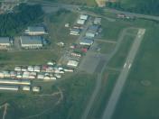
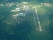
Rostraver Airport
Official FAA Data Effective 2026-01-22 0901Z
VFR Chart of KFWQ
Sectional Charts at SkyVector.com
IFR Chart of KFWQ
Enroute Charts at SkyVector.com
Location Information for KFWQ
Coordinates: N40°12.58' / W79°49.89'Located 05 miles E of Monongahela, Pennsylvania on 300 acres of land. View all Airports in Pennsylvania.
Surveyed Elevation is 1228 feet MSL.
Operations Data
|
|
Airport Communications
| AWOS-3: | 118.475 Tel. 724-379-5815 |
|---|---|
| PITTSBURGH APPROACH: | 119.35 337.4 |
| PITTSBURGH DEPARTURE: | 119.35 337.4 |
| CLASS B: | 119.35 337.4 |
| UNICOM: | 122.800 |
| CTAF: | 122.800 |
| ATIS at AGC (9.8 NW): | 120.55 |
| ASOS at AGC (9.8 NW): | 120.55 412-466-8968 |
| AWOS-A at 42PN (16.8 NW): | 412-442-2213 |
Nearby Navigation Aids
|
| ||||||||||||||||||||||||||||||||||||||||||||||||||||||||||||
Runway 08/26
| Dimensions: | 4002 x 75 feet / 1220 x 23 meters | |
|---|---|---|
| Surface: | Asphalt / Grooved in Good Condition | |
| Weight Limits: | S-26, D-30 | |
| Edge Lighting: | Medium Intensity | |
| Runway 08 | Runway 26 | |
| Coordinates: | N40°12.46' / W79°50.28' | N40°12.71' / W79°49.49' |
| Elevation: | 1228.1 | 1222.8 |
| Traffic Pattern: | Left RIGHT TRAFFIC HELICOPTERS/ULTRALIGHTS. |
Left RIGHT TRAFFIC HELICOPTERS/ULTRALIGHTS. |
| Runway Heading: | 67° True | 247° True |
| Markings: | Non-Precision Instrument in good condition. | Non-Precision Instrument in good condition. |
| Glide Slope Indicator | V4R (3.00° Glide Path Angle) | V4L (3.00° Glide Path Angle) |
| REIL: | Yes | Yes |
| Obstacles: | 127 ft Tower 4215 ft from runway, 245 ft right of center | |
Services Available
| Fuel: | 100LL (blue), Jet-A, Jet A+ |
|---|---|
| Transient Storage: | Hangars,Tiedowns |
| Airframe Repair: | MAJOR |
| Engine Repair: | MAJOR |
| Bottled Oxygen: | NONE |
| Bulk Oxygen: | NONE |
| Other Services: | AIR AMBULANCE SERVICES,AVIONICS,AIRCRAFT SALES |
Ownership Information
| Ownership: | Publicly owned | |
|---|---|---|
| Owner: | WESTMORELAND CO ARPT AUTH | |
| 148 AVIATION LANE, SUITE 103 | ||
| LATROBE, PA 15650 | ||
| 724-539-8100 | ||
| Manager: | GABE MONZO | |
| 605 AIRPORT RD | ||
| BELLE VERNON, PA 15012 | ||
| 724-379-6980 | ||
Other Remarks
- DEER & BIRDS ON & INVOF ARPT.
- FOR CD CTC PITTSBURGH APCH AT 412-472-5591.
- ACTVT REIL RWY 08/26; MIRL RWY 08/26 - CTAF.
Weather Minimums
Instrument Approach Procedure (IAP) Charts
Nearby Airports with Instrument Procedures
| ID | Name | Heading / Distance | ||
|---|---|---|---|---|
 |
G05 | Finleyville Airpark Airport | 284° | 8.5 |
 |
KAGC | Allegheny County Airport | 332° | 9.8 |
 |
KVVS | Joseph A Hardy Connellsville Airport | 151° | 17.0 |
 |
KLBE | Arnold Palmer Regional Airport | 078° | 19.7 |
 |
KAFJ | Washington County Airport | 258° | 21.6 |
 |
KWAY | Greene County Airport | 216° | 23.1 |
 |
KPIT | Pittsburgh International Airport | 312° | 25.0 |
 |
6P7 | Mcville Airport | 018° | 33.3 |
 |
KMGW | Morgantown Municipal/Walter L Bill Hart Field Airport | 186° | 34.2 |
 |
KBTP | Pittsburgh/Butler Regional Airport | 350° | 34.4 |
 |
KHLG | Wheeling Ohio County Airport | 267° | 37.5 |
 |
KPJC | Zelienople Municipal Airport | 337° | 38.6 |


