Login
Register


GGI
Grinnell Regional Airport
Official FAA Data Effective 2026-02-19 0901Z
Chart Supplement

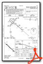
VFR Chart of KGGI
Sectional Charts at SkyVector.com
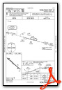
IFR Chart of KGGI
Enroute Charts at SkyVector.com
Location Information for KGGI
Coordinates: N41°42.59' / W92°44.16'Located 01 miles S of Grinnell, Iowa on 115 acres of land. View all Airports in Iowa.
Surveyed Elevation is 1008 feet MSL.
Operations Data
|
|
Airport Communications
| AWOS-3: | 120.725 Tel. 641-236-9720 |
|---|---|
| UNICOM: | 122.800 |
| CTAF: | 122.800 |
| AWOS-3 at TNU (12.9 W): | 132.275 641-791-3302 |
| AWOS-3 at PEA (20.9 SW): | 118.875 641-628-3459 |
| ASOS at MIW (25.5 N): | 128.325 641-752-2339 |
- APCH/DEP SVC PRVDD BY CHICAGO ARTCC ON FREQS 127.05/282.35 (DES MOINES RCAG).
Nearby Navigation Aids
|
| ||||||||||||||||||||||||||||||||||||||||||


Runway 13/31
| Dimensions: | 5200 x 75 feet / 1585 x 23 meters | |
|---|---|---|
| Surface: | Concrete / Grooved in Excellent Condition | |
| Weight Limits: | 12 /R/C/W/U, S-30, D-30 | |
| Edge Lighting: | Medium Intensity | |
| Runway 13 | Runway 31 | |
| Coordinates: | N41°42.87' / W92°44.59' | N41°42.31' / W92°43.73' |
| Elevation: | 988.8 | 1007.8 |
| Runway Heading: | 131° True | 311° True |
| Displaced Threshold: | 200 Feet | 200 Feet |
| Markings: | Non-Precision Instrument in good condition. | Non-Precision Instrument in good condition. |
| Glide Slope Indicator | P2L (3.00° Glide Path Angle) | P2L (3.00° Glide Path Angle) |
| REIL: | Yes | Yes |
| Obstacles: | 40 ft Tree 1230 ft from runway, 53 ft left of center RWY 13 APCH SLP 35:1 TO DSPLCD THR. |
52 ft Tree 1109 ft from runway, 84 ft left of center RWY 31 APCH SLP 25:1 TO DSPLCD THR. |
Services Available
| Fuel: | 100LL (blue), Jet-A |
|---|---|
| Transient Storage: | Hangars,Tiedowns |
| Airframe Repair: | MAJOR |
| Engine Repair: | MAJOR |
| Bottled Oxygen: | NOT AVAILABLE |
| Bulk Oxygen: | NOT AVAILABLE |
| Other Services: | CROP DUSTING SERVICES,PILOT INSTRUCTION,AIRCRAFT RENTAL |
Ownership Information
| Ownership: | Publicly owned | |
|---|---|---|
| Owner: | CITY OF GRINNELL | |
| CITY HALL 927 4TH AVE | ||
| GRINNELL, IA 50112 | ||
| 641-236-2605 | ||
| Manager: | RON LOWRY | |
| 1607 W ST S | ||
| GRINNELL, IA 50112 | ||
| 641-236-0188 | ||
Other Remarks
- RY 31 IS CALM WIND RY.
- FOR CD IF UNA TO CTC ON FSS FREQ, CTC CHICAGO ARTCC AT 630-906-8921.
- 0LL FOR FUEL AFT HRS CALL (641) 236-0188.
- MIRL RWY 13/31 PRESET ON LOW INTST; TO INCR INTST & ACTVT PAPI & REIL RWYS 13 & 31- CTAF.
Weather Minimums


Instrument Approach Procedure (IAP) Charts

Nearby Airports with Instrument Procedures
| ID | Name | Heading / Distance | ||
|---|---|---|---|---|
 |
KTNU | Newton Municipal-Earl Johnson Field Airport | 260° | 13.0 |
|
KPEA | Pella Municipal Airport | 207° | 20.8 |
|
KTZT | Belle Plaine Municipal Airport | 063° | 22.7 |
|
KMIW | Marshalltown Municipal Airport | 341° | 25.5 |
|
KOXV | Knoxville Municipal Airport | 214° | 29.9 |
|
KOOA | Oskaloosa Municipal Airport | 159° | 31.0 |
|
KIKV | Ankeny Regional Airport | 268° | 37.3 |
|
KOTM | Ottumwa Regional Airport | 160° | 38.4 |
|
4C8 | Albia Municipal Airport | 181° | 42.8 |
|
KDSM | Des Moines International Airport | 256° | 43.0 |
|
KAMW | Ames Municipal Airport | 293° | 43.2 |
|
KVTI | Vinton Veterans Memorial Airpark Airport | 045° | 44.1 |
Airport Images
Do you have a recent image of this airport? Upload it here!


