Login
Register


HDC
Hammond Northshore Regional Airport
Official FAA Data Effective 2026-02-19 0901Z
Chart Supplement

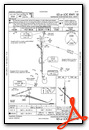
KHDC Airport Diagram

VFR Chart of KHDC
Sectional Charts at SkyVector.com
IFR Chart of KHDC
Enroute Charts at SkyVector.com
Location Information for KHDC
Coordinates: N30°31.30' / W90°25.10'Located 03 miles NE of Hammond, Louisiana on 920 acres of land. View all Airports in Louisiana.
Estimated Elevation is 46 feet MSL.
Operations Data
|
|
Airport Communications
| ATIS: | 118.325 |
|---|---|
| AWOS-3PT: | Tel. 985-277-5670 |
| HAMMOND TOWER: | 120.575 |
| HAMMOND GROUND: | 119.85 |
| NEW ORLEANS APPROACH: | 119.3 125.5 350.35 |
| NEW ORLEANS DEPARTURE: | 119.3 125.5 350.35 |
| CLEARANCE DELIVERY: | 119.3 ;WHEN TWR CLSD |
| CTAF: | 120.575 |
| AWOS-3PT at APS (27.5 S): | 125.45 985-536-1009 |
| ASOS at MSY (32.3 S): | 504-471-4486 |
| ASOS at ASD (32.7 E): | 132.475 985-643-7263 |
Nearby Navigation Aids
|
| ||||||||||||||||||||||||||||||||||||||||||||||||||||||||||||


Runway 13/31
| Dimensions: | 6502 x 100 feet / 1982 x 30 meters | |
|---|---|---|
| Surface: | Asphalt-Concrete in Good Condition | |
| Weight Limits: | S-22, D-33 | |
| Edge Lighting: | Medium Intensity | |
| Runway 13 | Runway 31 | |
| Coordinates: | N30°31.68' / W90°25.51' | N30°30.92' / W90°24.63' |
| Elevation: | 46.0 | 40.1 |
| Traffic Pattern: | Left | Left |
| Runway Heading: | 135° True | 315° True |
| Displaced Threshold: | 690 Feet | |
| Markings: | Non-Precision Instrument in good condition. | Non-Precision Instrument in good condition. |
| Glide Slope Indicator | P4L (3.30° Glide Path Angle) | P4L (3.30° Glide Path Angle) |
| REIL: | Yes | Yes |
| Obstacles: | 91 ft Trees 1700 ft from runway APCH SLOPE 26:1 TO DSPLCD THLD. |
|
Runway 18/36
| Dimensions: | 5001 x 150 feet / 1524 x 46 meters | |
|---|---|---|
| Surface: | Concrete in Good Condition | |
| Weight Limits: | S-27, D-41 | |
| Edge Lighting: | Medium Intensity | |
| Runway 18 | Runway 36 | |
| Coordinates: | N30°31.72' / W90°25.15' | N30°30.89' / W90°25.15' |
| Elevation: | 43.5 | 40.0 |
| Traffic Pattern: | Left | Left |
| Runway Heading: | 180° True | 360° True |
| Markings: | Precision Instrument in good condition. | Precision Instrument in good condition. |
| Glide Slope Indicator | P4L (3.00° Glide Path Angle) | P4L (3.00° Glide Path Angle) |
| Approach Lights: | MALSR 1,400 Foot Medium-intensity Approach Lighting System with runway alignment indicator lights. | |
| REIL: | Yes | |
Services Available
| Fuel: | 100LL (blue), Jet-A |
|---|---|
| Transient Storage: | Hangars,Tiedowns |
| Airframe Repair: | MAJOR |
| Engine Repair: | MAJOR |
| Bottled Oxygen: | NONE |
| Bulk Oxygen: | NONE |
| Other Services: | AIR AMBULANCE SERVICES,CHARTER SERVICE,PILOT INSTRUCTION,AIRCRAFT RENTAL |
Ownership Information
| Ownership: | Publicly owned | |
|---|---|---|
| Owner: | CITY OF HAMMOND | |
| PO BOX 2788 | ||
| HAMMOND, LA 70404-2788 | ||
| (985) 277-5601 | ||
| Manager: | TONY MICHELLI | |
| 600 JUDGE LEON FORD DRIVE | ||
| HAMMOND, LA 70401 | ||
| 985-277-5667 | ||
Other Remarks
- CTC APRT MGR FOR DSGND RAMP SPACE FOR PUB USE.
- BIRDS, DEER & COYOTES ON & INVOF ARPT.
- MIL & GOVT ACFT SVCD AT NW APN AT FBO.
- FOR CD WHEN ATCT IS CLSD CTC MSY APCH AT 504-471-4350 OR 119.3.
- CAUTION: TWY D UNMKD AND UNLGTD.
- PILOTS CONDUCTING EFVS OPS; BE AWARE LED ALS IN USE RWY 18.
- ACTVT MALSR RWY 18; REIL RWY 13, 31, & 36; MIRL RWY 13/31 & 18/36; PRESET LOW INTST DUSK-DAWN; TO INCR INTST - CTAF.
Weather Minimums


Instrument Approach Procedure (IAP) Charts


Nearby Airports with Instrument Procedures
| ID | Name | Heading / Distance | ||
|---|---|---|---|---|
 |
KAPS | Port of South Louisiana Exec Regional Airport | 198° | 27.4 |
|
KASD | Slidell Airport | 108° | 32.7 |
|
KMSY | Louis Armstrong New Orleans International Airport | 165° | 32.7 |
|
KBXA | George R Carr Memorial Air Field Airport | 058° | 33.6 |
|
KREG | Louisiana Regional Airport | 232° | 34.3 |
|
KNEW | Lakefront Airport | 144° | 35.1 |
|
KBTR | Baton Rouge Metro, Ryan Field Airport | 271° | 37.9 |
|
KMCB | Mc Comb/Pike County/John E Lewis Field Airport | 355° | 39.4 |
|
KMJD | Picayune Municipal Airport | 092° | 39.8 |
|
KNBG | New Orleans NAS Jrb (Alvin Callender Field) Airport | 153° | 46.3 |
|
M13 | Poplarville/Pearl River County Airport | 071° | 49.9 |
|
KHSA | Stennis International Airport | 100° | 50.8 |
Fuel Providers

Airport Images

By: Big Orange Bird


