Login
Register
IMT
Ford Airport
Official FAA Data Effective 2026-01-22 0901Z
VFR Chart of KIMT
Sectional Charts at SkyVector.com
IFR Chart of KIMT
Enroute Charts at SkyVector.com
Location Information for KIMT
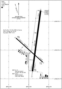
Coordinates: N45°49.10' / W88°6.87'Located 03 miles W of Iron Mountain Kingsford, Michigan on 720 acres of land. View all Airports in Michigan.
Surveyed Elevation is 1182 feet MSL.
TPA FOR JET/TURBO-JET AND PROP ACFT OVER 12500LBS IS 1500' AGL.
Operations Data
|
|
Airport Communications
| ASOS: | 119.025 Tel. 906-774-1999 |
|---|---|
| UNICOM: | 122.800 |
| CTAF: | 122.800 |
| AWOS-3PT at ESC (43.1 E): | 121.425 906-786-9001 |
| AWOS-3PT at SAW (43.4 NE): | 118.375 906-346-5126 |
| AWOS-3PT at MNM (46.1 SE): | 121.45 906-863-8801 |
- APCH/DEP SVC PRVDD BY MINNEAPOLIS ARTCC ON FREQS 121.25/322.5 (IRON MOUNTAIN RCAG).
Nearby Navigation Aids
|
| ||||||||||||||||||||||||||||||||||||||||||||||||
Runway 01/19
| Dimensions: | 6502 x 150 feet / 1982 x 46 meters | |
|---|---|---|
| Surface: | Asphalt / Porous Friction Course in Good Condition | |
| Weight Limits: | S-100, D-100, ST-190
PCR VALUE: 159/F/B/X/T
| |
| Edge Lighting: | High Intensity | |
| Runway 01 | Runway 19 | |
| Coordinates: | N45°48.63' / W88°6.91' | N45°49.69' / W88°6.70' |
| Elevation: | 1132.0 | 1182.0 |
| Traffic Pattern: | Left | Left |
| Runway Heading: | 8° True | 188° True |
| Declared Distances: | TORA:6502 TODA:6502 ASDA:6502 LDA:6502 | TORA:6502 TODA:6502 ASDA:6376 LDA:6376 |
| Markings: | Precision Instrument in good condition. | Precision Instrument in good condition. |
| Glide Slope Indicator | P4L (3.00° Glide Path Angle) | |
| Approach Lights: | MALSR 1,400 Foot Medium-intensity Approach Lighting System with runway alignment indicator lights. | |
| REIL: | Yes | |
Runway 13/31
RWY 13/31 NOT AVBL FOR PART 121/PART 380 OPS WITH SKED PAX CARRYING OPS MORE THAN 9 PAX SEATS AND NON-SKED PAX CARRYING OPS MORE THAN 30 PAX SEATS. | ||
| Dimensions: | 3810 x 75 feet / 1161 x 23 meters | |
|---|---|---|
| Surface: | Asphalt / Porous Friction Course in Fair Condition | |
| Weight Limits: | S-30, D-50, ST-80
PCR VALUE: 99/F/B/X/T
| |
| Edge Lighting: | Medium Intensity | |
| Runway 13 | Runway 31 | |
| Coordinates: | N45°49.21' / W88°7.32' | N45°48.79' / W88°6.65' |
| Elevation: | 1128.6 | 1124.8 |
| Traffic Pattern: | Left | Left |
| Runway Heading: | 132° True | 312° True |
| Declared Distances: | TORA:3810 TODA:3810 ASDA:3810 LDA:3810 | TORA:3810 TODA:3810 ASDA:3810 LDA:3810 |
| Markings: | Non-Precision Instrument in fair condition. | Non-Precision Instrument in fair condition. |
| Glide Slope Indicator | P4L (4.00° Glide Path Angle) | |
| REIL: | Yes | |
Services Available
| Fuel: | 100LL (blue), Jet-A |
|---|---|
| Transient Storage: | Hangars,Tiedowns |
| Airframe Repair: | MAJOR |
| Engine Repair: | MAJOR |
| Bottled Oxygen: | LOW |
| Bulk Oxygen: | NONE |
| Other Services: | AIR FREIGHT SERVICES,CHARTER SERVICE,PILOT INSTRUCTION,AIRCRAFT RENTAL |
Ownership Information
| Ownership: | Publicly owned | |
|---|---|---|
| Owner: | DICKINSON COUNTY | |
| COUNTY COURT HOUSE | ||
| IRON MOUNTAIN, MI 49802 | ||
| 906-774-2573 | ||
| Manager: | TIM HOWEN | |
| FORD ARPT | ||
| KINGSFORD, MI 49801 | ||
| 906-774-4870 | CELL 906-201-1866. | |
Other Remarks
- DEER, COYOTES, & BIRDS ON & INVOF ARPT.
- 48 HRS PPR FOR UNSKED ACR OPS GTR THAN 30 PAX SEATS - CALL AMGR CELL.
- ARFF CREWS MNT CTAF/UNICOM DRG ALL ACR OPS.
- SNOW REMOVAL CREWS MNT CTAF/UNICOM DRG ALL ACR OPS TO PRVD SFC COND RPRTS.
- FLD CONDS UNMON OCT 15 THRU APR 1 BTN 2100-0600.
- ACTVT MALSR RWY 01; REIL RWY 19 & 31; PAPI RWY 19 & 31; HIRL RWY 01/19; MIRL RWY 13/31 - CTAF.
- UNICOM IREG MNTD.
- TPA FOR JET/TURBO-JET AND PROP ACFT OVER 12500LBS IS 1500' AGL.
Weather Minimums
Instrument Approach Procedure (IAP) Charts
Nearby Airports with Instrument Procedures
| ID | Name | Heading / Distance | ||
|---|---|---|---|---|
 |
Y55 | Crandon/Steve Conway Municipal Airport | 242° | 38.6 |
 |
KESC | Delta County Airport | 097° | 43.3 |
 |
KSAW | Marquette/Sawyer Regional Airport | 043° | 43.8 |
 |
KMNM | Menominee Regional Airport | 153° | 46.1 |
 |
KEGV | Eagle River Union Airport | 278° | 48.8 |
 |
KLNL | Kings Land O' Lakes Airport | 294° | 50.1 |
 |
2P2 | Washington Island Airport | 116° | 56.4 |
 |
3D2 | Ephraim/Gibraltar Airport | 136° | 56.7 |
 |
KOCQ | Oconto/J Douglas Bake Municipal Airport | 171° | 57.3 |
 |
KRHI | Rhinelander/Oneida County Airport | 259° | 57.9 |
 |
KAIG | Langlade County Airport | 226° | 57.9 |
 |
KEZS | Shawano Municipal Airport | 197° | 64.7 |


