Login
Register


AIG
Langlade County Airport
Official FAA Data Effective 2026-01-22 0901Z
Chart Supplement

VFR Chart of KAIG
Sectional Charts at SkyVector.com
IFR Chart of KAIG
Enroute Charts at SkyVector.com
Location Information for KAIG
Coordinates: N45°9.24' / W89°6.64'Located 02 miles NE of Antigo, Wisconsin on 440 acres of land. View all Airports in Wisconsin.
Surveyed Elevation is 1523 feet MSL.
Operations Data
|
|
Airport Communications
| AWOS-3: | 119.075 Tel. 715-627-2869 |
|---|---|
| CTAF: | 122.800 |
| UNICOM: | 122.800 |
| AWOS-3 at RRL (25.5 W): | 119.925 715-539-8422 |
| ASOS at AUW (25.8 SW): | 125.925 715-843-7215 |
| AWOS-3 at EZS (32.0 SE): | 118.65 715-526-2967 |
- APCH/DEP SVC PRVDD BY MINNEAPOLIS ARTCC ON FREQS 124.4/317.7 (MOSINEE RCAG).
Nearby Navigation Aids
|
| ||||||||||||||||||||||||||||||||||||||||||||||||||||||||||||


Runway 17/35
| Dimensions: | 4010 x 75 feet / 1222 x 23 meters | |
|---|---|---|
| Surface: | Asphalt / Aggregate Friction Seal Coated in Fair Condition | |
| Weight Limits: | S-21 | |
| Edge Lighting: | Medium Intensity | |
| Runway 17 | Runway 35 | |
| Coordinates: | N45°9.55' / W89°6.62' | N45°8.91' / W89°6.36' |
| Elevation: | 1520.5 | 1517.9 |
| Traffic Pattern: | Left | Left |
| Runway Heading: | 164° True | 344° True |
| Markings: | Non-Precision Instrument in fair condition. | Non-Precision Instrument in fair condition. |
| Glide Slope Indicator | P2L (3.00° Glide Path Angle) | P2L (3.00° Glide Path Angle) PAPI UNUSBL BYD 7 DEGS LEFT OF CNTRLN. |
| REIL: | Yes | Yes |
Runway 09/27
| Dimensions: | 3400 x 75 feet / 1036 x 23 meters | |
|---|---|---|
| Surface: | Asphalt / Aggregate Friction Seal Coated in Excellent Condition | |
| Weight Limits: | S-12 | |
| Edge Lighting: | Medium Intensity | |
| Runway 09 | Runway 27 | |
| Coordinates: | N45°9.21' / W89°7.20' | N45°9.28' / W89°6.42' |
| Elevation: | 1516.0 | 1522.8 |
| Runway Heading: | 83° True | 263° True |
| Markings: | Non-Precision Instrument in good condition. | Non-Precision Instrument in good condition. |
| Glide Slope Indicator | P2L (3.00° Glide Path Angle) | P2L (3.00° Glide Path Angle) |
Services Available
| Fuel: | 100LL (blue), Jet-A |
|---|---|
| Transient Storage: | Hangars,Tiedowns |
| Airframe Repair: | MINOR |
| Engine Repair: | MINOR |
| Bottled Oxygen: | NONE |
| Bulk Oxygen: | NONE |
| Other Services: | CROP DUSTING SERVICES,PILOT INSTRUCTION,AIRCRAFT RENTAL |
Ownership Information
| Ownership: | Publicly owned | |
|---|---|---|
| Owner: | LANGLADE COUNTY | |
| N3689 N LANGLADE RD | ||
| ANTIGO, WI 54409 | ||
| (715) 623-3539 | ||
| Manager: | DONALD BINTZ | |
| N3689 N LANGLADE RD | ||
| ANTIGO, WI 54409 | ||
| 702-324-9966 | ||
Other Remarks
- FOR CD CTC MINNEAPOLIS ARTCC AT 651-463-5588.
- MIRL RWY 17/35 & 09/27 PRESET TO LOW SS-SR; TO INCR INTST AND ACTVT REIL RWY 17 & 35; PAPI RWY 09, 17, 27 & 35 - CTAF.
Weather Minimums


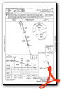
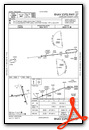
Instrument Approach Procedure (IAP) Charts


Nearby Airports with Instrument Procedures
| ID | Name | Heading / Distance | ||
|---|---|---|---|---|
 |
Y55 | Crandon/Steve Conway Municipal Airport | 019° | 23.4 |
|
KRRL | Merrill Municipal Airport | 276° | 25.7 |
|
KAUW | Wausau Downtown Airport | 238° | 25.9 |
|
KEZS | Shawano Municipal Airport | 132° | 32.2 |
|
KRHI | Rhinelander/Oneida County Airport | 332° | 32.3 |
|
KCWA | Central Wisconsin Airport | 226° | 32.7 |
|
KTKV | Tomahawk Regional Airport | 303° | 35.0 |
|
KCLI | Clintonville Municipal Airport | 153° | 36.3 |
|
KSTE | Stevens Point Municipal Airport | 206° | 40.7 |
|
KEGV | Eagle River Union Airport | 351° | 47.2 |
|
KPCZ | Waupaca Municipal Airport | 175° | 49.4 |
|
KMDZ | Taylor County Airport | 266° | 50.6 |
Airport Images
Do you have a recent image of this airport? Upload it here!


