Login
Register
IXD
New Century Aircenter Airport
Official FAA Data Effective 2026-01-22 0901Z
From the Flight Deck
VFR Chart of KIXD
Sectional Charts at SkyVector.com
IFR Chart of KIXD
Enroute Charts at SkyVector.com
Location Information for KIXD
Coordinates: N38°49.86' / W94°53.42'Located 04 miles SW of Olathe, Kansas on 2600 acres of land. View all Airports in Kansas.
Surveyed Elevation is 1087 feet MSL.
Operations Data
|
|
Airport Communications
| ASOS: | 135.325 Tel. 913-780-6987 |
|---|---|
| NEW CENTURY TOWER: | 133.0 |
| NEW CENTURY GROUND: | 124.3 |
| KANSAS CITY APPROACH: | 118.9 251.075 |
| KANSAS CITY DEPARTURE: | 118.9 251.075 |
| CTAF: | 133.000 |
| UNICOM: | 122.950 |
| TYGER STAR: | 120.95 318.1 |
| JHAWK STAR: | 120.95 318.1 |
| BRAYMER STAR: | 120.95 318.1 |
| ARMY OPS: | 347.5 46.9FM |
| ASOS at OJC (7.2 E): | 913-780-6969 |
| ATIS at OJC (7.2 E): | 119.35 |
| ASOS at LWC (18.7 NW): | 121.225 785-749-1309 |
Nearby Navigation Aids
|
| ||||||||||||||||||||||||||||||||||||||||||||||||||||||||||||
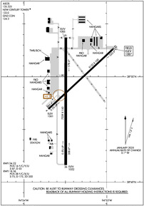
Runway 18/36
| Dimensions: | 7339 x 150 feet / 2237 x 46 meters | |
|---|---|---|
| Surface: | Asphalt in Good Condition | |
| Weight Limits: | 28 /F/C/X/U, S-75, D-175, ST-350 | |
| Edge Lighting: | High Intensity | |
| Runway 18 | Runway 36 | |
| Coordinates: | N38°50.37' / W94°53.49' | N38°49.16' / W94°53.50' |
| Elevation: | 1084.9 | 1051.5 |
| Traffic Pattern: | Left | Right |
| Runway Heading: | 180° True | 0 |
| Markings: | Precision Instrument in good condition. | Precision Instrument in good condition. |
| Glide Slope Indicator | V2L (3.00° Glide Path Angle) | |
| Approach Lights: | MALSR 1,400 Foot Medium-intensity Approach Lighting System with runway alignment indicator lights. | |
| REIL: | Yes | |
Runway 04/22
| Dimensions: | 5132 x 100 feet / 1564 x 30 meters | |
|---|---|---|
| Surface: | Asphalt in Fair Condition | |
| Weight Limits: | 16 /F/C/Y/U, S-47, D-55 | |
| Edge Lighting: | Medium Intensity | |
| Runway 04 | Runway 22 | |
| Coordinates: | N38°49.69' / W94°53.70' | N38°50.27' / W94°52.91' |
| Elevation: | 1061.1 | 1087.2 |
| Traffic Pattern: | Right | Left |
| Runway Heading: | 47° True | 227° True |
| Markings: | Non-Precision Instrument in good condition. | Non-Precision Instrument in good condition. |
| Glide Slope Indicator | P4L (3.00° Glide Path Angle) | P4L (3.00° Glide Path Angle) |
Services Available
| Fuel: | 100LL (blue), Jet-A |
|---|---|
| Transient Storage: | Hangars,Tiedowns |
| Airframe Repair: | MAJOR |
| Engine Repair: | MAJOR |
| Bottled Oxygen: | HIGH/LOW |
| Bulk Oxygen: | HIGH/LOW |
| Other Services: | AVIONICS,CHARTER SERVICE,PILOT INSTRUCTION,AIRCRAFT RENTAL,AIRCRAFT SALES,ANNUAL SURVEYING |
Ownership Information
| Ownership: | Publicly owned | |
|---|---|---|
| Owner: | JOHNSON CO | |
| ONE NEW CENTURY PARKWAY | ||
| NEW CENTURY, KS 66031 | ||
| 913-715-6000 | ||
| Manager: | BRYAN JOHNSON | |
| ONE NEW CENTURY PARKWAY | ||
| NEW CENTURY, KS 66031 | ||
| 913-715-6002 | ||
Other Remarks
- BIRDS & WATERFOWL ON & INVOF ARPT.
- ATCT VIEW OF SW END OF TWY 'F' & RWY 04/22 IS OBSCURED.
- LOW SUN ANGLES RDC VSBY WHEN XING RWY 18/36 FM TWYS 'A' OR 'B'.
- ARMY OPS: DSN 552-6994/5, C913-782-1077.
- TO CONFIRM SNOW REMOVAL AND WINTER CONDITIONS NOV-APR CALL 913-715-6005.
- FOR CD WHEN ATCT IS CLSD CTC MCI APCH AT 118.90.
- WHEN TWR CLSD ACTVT MALSR RWY 36; REIL RWY 18; HIRL RWY 18-36, MIRL RWY 4-22; TWY LGTS; WIND CONE - CTAF.
Weather Minimums
Standard Terminal Arrival (STAR) Charts
Instrument Approach Procedure (IAP) Charts
Departure Procedure (DP) Charts
Nearby Airports with Instrument Procedures
| ID | Name | Heading / Distance | ||
|---|---|---|---|---|
 |
KOJC | Johnson County Exec Airport | 082° | 7.2 |
 |
K81 | Miami County Airport | 184° | 17.5 |
 |
KLWC | Lawrence Regional Airport | 305° | 18.7 |
 |
KMKC | Kansas City Downtown/Wheeler Field Airport | 038° | 22.4 |
 |
KOWI | Ottawa Municipal Airport | 224° | 24.4 |
 |
KLXT | Kansas City/Lee's Summit Regional Airport | 072° | 25.5 |
 |
KLRY | Lawrence Smith Memorial Airport | 117° | 28.9 |
 |
KMCI | Kansas City International Airport | 016° | 29.2 |
 |
KFLV | Sherman AAF Airport | 358° | 32.2 |
 |
3GV | East Kansas City Airport | 070° | 33.5 |
 |
KFOE | Topeka Regional Airport | 281° | 36.9 |
 |
KTOP | Philip Billard Municipal Airport | 292° | 37.1 |


