Login
Register


LUM
Menomonie Municipal/Score Field Airport
Official FAA Data Effective 2026-02-19 0901Z
Chart Supplement

VFR Chart of KLUM
Sectional Charts at SkyVector.com
IFR Chart of KLUM
Enroute Charts at SkyVector.com
Location Information for KLUM
Coordinates: N44°53.54' / W91°52.07'Located 03 miles E of Menomonie, Wisconsin on 277 acres of land. View all Airports in Wisconsin.
Surveyed Elevation is 895 feet MSL.
Operations Data
|
|
Airport Communications
| AWOS-3PT: | 118.025 |
|---|---|
| CTAF: | 123.075 |
| UNICOM: | 123.075 |
| ATIS at EAU (16.4 E): | 126.025 |
| ASOS at EAU (16.4 E): | 126.025 715-832-7990 |
| AWOS-3P at Y23 (26.9 N): | 119.05 715-924-1836 |
- APCH/DEP SVC PRVDD BY MINNEAPOLIS ARTCC ON FREQS 125.3/335.6 (EAU CLAIRE RCAG).
Nearby Navigation Aids
|
| ||||||||||||||||||||||||||||||||||||||||||||||||||||||||||||


Runway 09/27
| Dimensions: | 5074 x 75 feet / 1547 x 23 meters | |
|---|---|---|
| Surface: | Asphalt in Fair Condition | |
| Edge Lighting: | Medium Intensity | |
| Runway 09 | Runway 27 | |
| Coordinates: | N44°53.45' / W91°52.61' | N44°53.46' / W91°51.44' |
| Elevation: | 892.3 | 892.6 |
| Runway Heading: | 89° True | 269° True |
| Markings: | Non-Precision Instrument in fair condition. | Non-Precision Instrument in fair condition. |
| Glide Slope Indicator | P2L (3.00° Glide Path Angle) | P2L (3.00° Glide Path Angle) |
| REIL: | Yes | Yes |
| Obstacles: | FARM EQUIP. CTLNG OBSTN EXCEEDS A 45 DEG SLP. |
15 ft Other 200 ft from runway, 300 ft left of center 20 FT BLDG 100 FT FM RWY END, 325 FT L. |
Runway 18/36
| Dimensions: | 3470 x 75 feet / 1058 x 23 meters | |
|---|---|---|
| Surface: | Asphalt in Fair Condition | |
| Edge Lighting: | Medium Intensity | |
| Runway 18 | Runway 36 | |
| Coordinates: | N44°53.95' / W91°52.15' | N44°53.38' / W91°52.11' |
| Elevation: | 895.0 | 892.9 |
| Runway Heading: | 177° True | 357° True |
| Markings: | Non-Precision Instrument in fair condition. | Non-Precision Instrument in fair condition. |
| Glide Slope Indicator | P2L (3.00° Glide Path Angle) | P2R (3.00° Glide Path Angle) |
Services Available
| Fuel: | 100LL (blue), Jet A+ |
|---|---|
| Transient Storage: | Hangars,Tiedowns |
| Airframe Repair: | MAJOR |
| Engine Repair: | MAJOR |
| Bottled Oxygen: | NONE |
| Bulk Oxygen: | NOT AVAILABLE |
| Other Services: | AVIONICS,PILOT INSTRUCTION,AIRCRAFT RENTAL |
Ownership Information
| Ownership: | Publicly owned | |
|---|---|---|
| Owner: | CITY OF MENOMONIE | |
| 800 WILSON AVE | ||
| MENOMONIE, WI 54751-2795 | ||
| 715-232-2187 | ||
| Manager: | DARREL GIBSON | |
| 1400 INDIANHEAD DR. | ||
| MENOMONIE, WI 54751 | ||
| 715-220-6549 | ||
Other Remarks
- SEASONAL BIRDS ON & INVOF ARPT.
- FOR CD CTC MINNEAPOLIS ARTCC AT 651-463-5588.
- NOISE SENSITIVE NBRHD W OF RWY 27.
- 0LL 24 HR SELF SVC FUEL AVBL WITH CREDIT CARD; CTC AMGR FOR ASSTNC.
- MIRL RWY 9/27 PRESET TO LOW SS-SR; TO INCR INTST AND ACTVT REIL RWYS 09 & 27; PAPI RWYS 09, 18, 27, & 36; MIRL RWY 09/27 & 18/36 - CTAF.
Weather Minimums


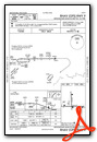
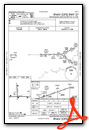
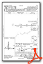
Instrument Approach Procedure (IAP) Charts
Nearby Airports with Instrument Procedures
| ID | Name | Heading / Distance | ||
|---|---|---|---|---|
 |
3T3 | Boyceville Municipal Airport | 324° | 11.2 |
|
KEAU | Chippewa Valley Regional Airport | 095° | 16.4 |
|
Y23 | Chetek Municipal/Southworth Airport | 021° | 26.7 |
|
KAHH | Amery Municipal Airport | 317° | 31.8 |
|
KRPD | Rice Lake Regional/Carl's Field Airport | 007° | 31.9 |
|
KRGK | Red Wing Regional Airport | 235° | 32.0 |
|
KRNH | New Richmond Regional Airport | 298° | 32.4 |
|
KUBE | Cumberland Municipal Airport | 352° | 37.1 |
|
21D | Lake Elmo Airport | 278° | 42.5 |
|
KOEO | L O Simenstad Municipal Airport | 305° | 43.0 |
|
KONA | Winona Municipal/Max Conrad Field Airport | 172° | 49.2 |
|
KSGS | South St Paul Municipal/Richard E Fleming Field Airport | 267° | 49.8 |
Airport Images
Do you have a recent image of this airport? Upload it here!


Comments
Fuel at LUM
Gibson Aviation has nice cheap gas - $4.95 last I checked. Great bunch of guys too.
Jon Pierce-Ruhland