Login
Register


MKJ
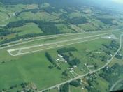
Mountain Empire Airport
Official FAA Data Effective 2026-01-22 0901Z
Chart Supplement

VFR Chart of KMKJ
Sectional Charts at SkyVector.com
IFR Chart of KMKJ
Enroute Charts at SkyVector.com
Location Information for KMKJ
Coordinates: N36°53.69' / W81°21.00'Located 09 miles NE of Marion/Wytheville, Virginia on 120 acres of land. View all Airports in Virginia.
Surveyed Elevation is 2558 feet MSL.
Operations Data
|
|
Airport Communications
| AWOS-3: | 123.875 Tel. 276-686-6420 |
|---|---|
| UNICOM: | 122.700 |
| CTAF: | 122.700 |
| AWOS-3 at JFZ (23.7 NW): | 118.075 276-596-9927 |
| ASOS at BLF (25.2 N): | 132.725 304-327-5766 |
| AWOS-3 at HLX (26.6 E): | 118.375 276-728-5897 |
- APCH/DEP SVC PRVDD BY ATLANTA ARTCC ON FREQS 127.85/269.3 (TRI CITY RCAG).
Nearby Navigation Aids
|
| ||||||||||||||||||||||||||||||||||||||||||||||||||||||||||||


Runway 08/26
| Dimensions: | 5252 x 75 feet / 1601 x 23 meters | |
|---|---|---|
| Surface: | Asphalt in Excellent Condition | |
| Weight Limits: | S-20 | |
| Edge Lighting: | Medium Intensity | |
| Runway 08 | Runway 26 | |
| Coordinates: | N36°53.57' / W81°21.51' | N36°53.82' / W81°20.48' |
| Elevation: | 2558.2 | 2502.7 |
| Traffic Pattern: | Left | Left |
| Runway Heading: | 73° True | 253° True |
| Markings: | Non-Precision Instrument in good condition. | Non-Precision Instrument in good condition. |
| Glide Slope Indicator | P2L (3.00° Glide Path Angle) | P2L (3.75° Glide Path Angle) |
| REIL: | Yes | Yes |
| Obstacles: | 26 ft Trees 612 ft from runway, 213 ft left of center 8 FT BUSH 80 FT FRM THLD, 120 L OF CNTRLN ON APCH. |
44 ft Tree 711 ft from runway, 321 ft right of center 17 FT ROADWAY CLNC PENETRATES APCH BY 9 FT. INTERSTATE TFC PENETRATES INTO PRI SFC. |
Services Available
| Fuel: | 100LL (blue), Jet A+ |
|---|---|
| Transient Storage: | Hangars,Tiedowns |
| Airframe Repair: | MAJOR |
| Engine Repair: | MAJOR |
| Bottled Oxygen: | NONE |
| Bulk Oxygen: | NONE |
Ownership Information
| Ownership: | Publicly owned | |
|---|---|---|
| Owner: | SMYTH WYTHE ARPT CMSN | |
| 8223 LEE HIGHWAY | ||
| RURAL RETREAT, VA 24368 | ||
| 276-783-8805 | ||
| Manager: | BRIAN BURKETT | |
| 8223 LEE HIGHWAY | ||
| RURAL RETREAT, VA 24368 | ||
| 276-783-8805 | ||
Other Remarks
- THIS AIRPORT HAS BEEN SURVEYED BY THE NATIONAL GEODETIC SURVEY.
- AFT HRS CTC 276-685-1122.
- FOR CD CTC ATLANTA ARTCC AT 770-210-7692.
- LCTD 9 NM NE MARION.
- MIRL RWY 08/26 PRESET LOW INTST; ACTVT HIGHER INTST - CTAF.
Weather Minimums

Instrument Approach Procedure (IAP) Charts
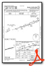
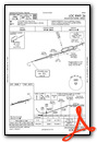
Nearby Airports with Instrument Procedures
| ID | Name | Heading / Distance | ||
|---|---|---|---|---|
 |
KJFZ | Tazewell County Airport | 295° | 23.8 |
|
KBLF | Mercer County Airport | 015° | 25.0 |
|
KHLX | Twin County Airport | 106° | 26.5 |
|
KGEV | Ashe County Airport | 186° | 27.9 |
|
KVJI | Virginia Highlands Airport | 249° | 35.3 |
|
KPSK | New River Valley Airport | 065° | 35.4 |
|
6A4 | Johnson County Airport | 218° | 36.6 |
|
KUKF | Wilkes County Airport | 163° | 42.0 |
|
I16 | Kee Field Airport | 346° | 43.5 |
|
KZEF | Elkin Municipal Airport | 143° | 45.8 |
|
KMWK | Mount Airy/Surry County Airport | 123° | 46.4 |
|
KBCB | Virginia Tech/Montgomery Exec Airport | 067° | 48.8 |