Login
Register


OSA
Mount Pleasant Regional Airport
Official FAA Data Effective 2025-11-27 0901Z
Chart Supplement

VFR Chart of KOSA
Sectional Charts at SkyVector.com
IFR Chart of KOSA
Enroute Charts at SkyVector.com
Location Information for KOSA
Coordinates: N33°5.81' / W94°57.70'Located 03 miles S of Mount Pleasant, Texas on 309 acres of land. View all Airports in Texas.
Surveyed Elevation is 364 feet MSL.
Operations Data
|
|
Airport Communications
| AWOS-3: | 119.775 Tel. 903-575-4027 |
|---|---|
| CTAF: | 122.700 |
| UNICOM: | 122.700 |
| AWOS-3PT at JXI (23.6 S): | 120.250 903-734-7313 |
| AWOS-3 at SLR (33.4 W): | 118.35 903-885-9605 |
| AWOS-3 at JDD (34.3 SW): | 118.9 903-768-3065 |
- APCH/DEP SVC PRVDD BY FORT WORTH ARTCC (ZFW) ON FREQS 132.025/317.75 (CUMBY RCAG).
Nearby Navigation Aids
|
| ||||||||||||||||||||||||||||||||||||||||||||||||||||||||||||


Runway 17/35
| Dimensions: | 6004 x 100 feet / 1830 x 30 meters | |
|---|---|---|
| Surface: | Asphalt in Good Condition | |
| Weight Limits: | S-30 | |
| Edge Lighting: | Medium Intensity | |
| Runway 17 | Runway 35 | |
| Coordinates: | N33°6.30' / W94°57.79' | N33°5.32' / W94°57.62' |
| Elevation: | 364.2 | 341.5 |
| Runway Heading: | 172° True | 352° True |
| Markings: | Non-Precision Instrument in poor condition. | Non-Precision Instrument in poor condition. |
| Glide Slope Indicator | P4L (3.00° Glide Path Angle) | P4L (3.00° Glide Path Angle) |
| REIL: | Yes | Yes |
| Obstacles: | 80 ft Trees 2300 ft from runway, 30 ft right of center | |
Helipad H1
| Dimensions: | 44 x 44 feet / 13 x 13 meters | |
|---|---|---|
| Surface: | Concrete in Fair Condition | |
| Coordinates: | N33°5.84' / W94°57.80' | N0°0.00' / E0°0.00' |
| Elevation: | 364.2 | |
| Markings: | Basic in poor condition. | |
Services Available
| Fuel: | 100LL (blue), Jet-A |
|---|---|
| Transient Storage: | Hangars,Tiedowns |
| Airframe Repair: | MAJOR |
| Engine Repair: | MAJOR |
| Bottled Oxygen: | NOT AVAILABLE |
| Bulk Oxygen: | NOT AVAILABLE |
Ownership Information
| Ownership: | Publicly owned | |
|---|---|---|
| Owner: | CITY OF MOUNT PLEASANT | |
| 501 NORTH MADISON | ||
| MOUNT PLEASANT, TX 75455 | ||
| 903-575-4000 | ||
| Manager: | PAUL HENDERSON | |
| 501 MIKE HALL PARKWAY | ||
| MOUNT PLEASANT, TX 75455 | ||
| 903-575-4020 | PHENDERSON@MPCITY.ORG | |
Other Remarks
- DEER & WILDLIFE ON & INVOF ARPT.
- NO LINE OF SIGHT BETWEEN RWY ENDS.
- FOR CD CTC FORT WORTH ARTCC AT 817-858-7584.
- MKGS DISCOLORED.
- MKGS DISCOLORED.
- MKGS DISCOLORED.
- 0LL FOR JET A AFT HRS CALL 903-575-4004. 100LL AVBL 24 HRS SELF SERV.
- REIL RWY 17 & 35, MIRL RWY 17/35 PRE-SET ON LOW SS-SR. TO ACTVT DAYTIME & INCR INTST - CTAF. PAPI RWY 17 & 35 OPR CONSLY.
Weather Minimums

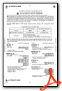
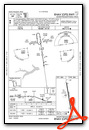
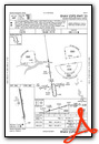
Instrument Approach Procedure (IAP) Charts
Nearby Airports with Instrument Procedures
| ID | Name | Heading / Distance | ||
|---|---|---|---|---|
 |
F53 | Franklin County Airport | 297° | 15.6 |
|
F51 | Winnsboro Municipal Airport | 239° | 18.6 |
|
KJXI | Fox Stephens Field/Gilmer Municipal Airport | 178° | 23.9 |
|
KSLR | Sulphur Springs Municipal Airport | 276° | 33.4 |
|
07F | Gladewater Municipal Airport | 180° | 34.0 |
|
KJDD | Wood County/Collins Field Airport | 231° | 34.4 |
|
KATA | Hall-Miller Municipal Airport | 089° | 38.6 |
|
KPRX | Cox Field Airport | 322° | 40.6 |
|
KGGG | East Texas Regional Airport | 163° | 44.5 |
|
KASL | Harrison County Airport | 136° | 47.8 |
|
2F7 | Commerce Municipal Airport | 284° | 48.5 |
|
4O4 | Mc Curtain County Regional Airport | 005° | 48.9 |
Airport Images
Do you have a recent image of this airport? Upload it here!


