Login
Register


SGH
Springfield/Beckley Municipal Airport
Official FAA Data Effective 2026-01-22 0901Z
Chart Supplement

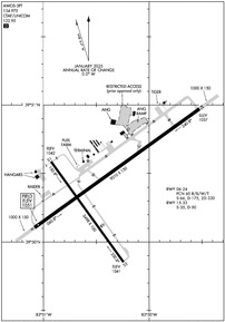
KSGH Airport Diagram
VFR Chart of KSGH
Sectional Charts at SkyVector.com
IFR Chart of KSGH
Enroute Charts at SkyVector.com
Location Information for KSGH
Coordinates: N39°50.42' / W83°50.41'Located 05 miles S of Springfield, Ohio on 1516 acres of land. View all Airports in Ohio.
Surveyed Elevation is 1051 feet MSL.
OHD TPA 1549 FT AGL.
Operations Data
|
|
Airport Communications
| AWOS-3PT: | 134.975 Tel. 937-324-4532 |
|---|---|
| COLUMBUS APPROACH: | 118.85 269.275 |
| COLUMBUS DEPARTURE: | 118.85 269.275 |
| IC: | 269.275 |
| DANEI STAR: | 134.45 323.15 |
| CTAF: | 122.950 |
| UNICOM: | 122.950 |
| ATIS at FFO (9.5 W): | 269.9 |
| AWOS-3 at GDK (11.2 SW): | 118.525 937-372-4668 |
| ATIS at DAY (17.9 W): | 125.8 |
Nearby Navigation Aids
|
| ||||||||||||||||||||||||||||||||||||||||||||||||||||||||||||


Runway 06/24
| Dimensions: | 9010 x 150 feet / 2746 x 46 meters | |
|---|---|---|
| Surface: | Asphalt-Concrete / Grooved in Fair Condition NE 980 FT CONC, SW 1200 FT CONC, 6830 FT ASPH BTN. | |
| Weight Limits: | 60 /R/B/W/T, S-66, D-175, ST-330 | |
| Edge Lighting: | High Intensity | |
| Runway 06 | Runway 24 | |
| Coordinates: | N39°50.10' / W83°51.08' | N39°50.97' / W83°49.52' |
| Elevation: | 1051.3 | 1036.9 |
| Traffic Pattern: | Left | Left |
| Runway Heading: | 54° True | 234° True |
| Declared Distances: | TORA:9009 TODA:9009 ASDA:9009 LDA:9009 | TORA:9009 TODA:9009 ASDA:9009 LDA:9009 |
| Markings: | Precision Instrument in good condition. | Precision Instrument in good condition. |
| Glide Slope Indicator | P4L (3.00° Glide Path Angle) | P4L (3.00° Glide Path Angle) |
| Approach Lights: | SSALR Simplified Short Approach Lighting System with runway alignment indicator lights. ALS UNMON INDEFLY. | |
| REIL: | Yes | |
| Obstacles: | 58 ft Trees 1697 ft from runway, 161 ft left of center | 70 ft Tree 1939 ft from runway, 462 ft right of center |
Runway 15/33
| Dimensions: | 5498 x 100 feet / 1676 x 30 meters | |
|---|---|---|
| Surface: | Asphalt in Excellent Condition | |
| Weight Limits: | S-35, D-50 | |
| Edge Lighting: | Medium Intensity | |
| Runway 15 | Runway 33 | |
| Coordinates: | N39°50.59' / W83°50.93' | N39°49.85' / W83°50.24' |
| Elevation: | 1042.1 | 1041.3 |
| Traffic Pattern: | Left | Left |
| Runway Heading: | 144° True | 324° True |
| Declared Distances: | TORA:5499 TODA:5499 ASDA:5499 LDA:5499 | TORA:5499 TODA:5499 ASDA:5499 LDA:5499 |
| Markings: | Non-Precision Instrument in good condition. | Non-Precision Instrument in good condition. |
| Glide Slope Indicator | P4L (3.00° Glide Path Angle) PAPI UNUSBL BYD 9 DEGS RIGHT OF CNTRLN. | P4L (3.00° Glide Path Angle) |
| REIL: | Yes | Yes |
| Obstacles: | 7 ft Crops 287 ft from runway, 131 ft right of center | 55 ft Trees 1450 ft from runway, 154 ft right of center |
Services Available
| Fuel: | 100LL (blue), Jet A+ |
|---|---|
| Transient Storage: | Hangars,Tiedowns PRIOR CDN RQRD. |
| Airframe Repair: | MAJOR |
| Engine Repair: | MAJOR |
| Bottled Oxygen: | LOW |
| Bulk Oxygen: | HIGH |
| Other Services: | AVIONICS,PILOT INSTRUCTION,AIRCRAFT SALES |
Ownership Information
| Ownership: | Publicly owned | |
|---|---|---|
| Owner: | CITY OF SPRINGFIELD | |
| 76 E HIGH ST | ||
| SPRINGFIELD, OH 45502-1214 | ||
| 937-325-6108 | ||
| Manager: | SETH TIMMERMAN | |
| 1251 W BLEE RD | ||
| SPRINGFIELD, OH 45502-8729 | ||
| 937-325-6108 | ||
Other Remarks
- NOISE ABATEMENT: AVOID OVERFLYING YELLOW SPRINGS 2 NM SW BLW 4000 FT.
- AVOID OVERFLYING ANG RAMP.
- FOR CD CTC COLUMBUS APCH AT 614-338-8537.
- OCNL DEER, BIRDS, & OTR WILDLIFE ON & INVOF ARPT.
- HVY BIRD ACT DRG FALL & WINTER MONTHS.
- PREF RWY WIND 10 KT OR LESS.
- ACTVT WIND CONE; SSALR RWY 24; REIL RWY 06, 15, & 33; HIRL RWY 06/24; MIRL RWY 15/33 - CTAF. PAPI RWY 06, 24, 15, & 33 OPR CONSLY.
- OHD TPA 1549 FT AGL.
Weather Minimums


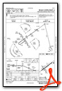
Standard Terminal Arrival (STAR) Charts
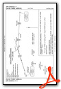
Instrument Approach Procedure (IAP) Charts


Nearby Airports with Instrument Procedures
| ID | Name | Heading / Distance | ||
|---|---|---|---|---|
 |
KFFO | Wright-Patterson AFB Airport | 264° | 9.6 |
|
KGDK | Greene County/Lewis A Jackson Regional Airport | 218° | 11.4 |
|
KDAY | James M Cox Dayton International Airport | 282° | 17.9 |
|
I74 | Grimes Field Airport | 012° | 18.0 |
|
KUYF | Madison County Airport | 072° | 18.3 |
|
I66 | Clinton Field Airport | 183° | 20.3 |
|
I73 | Moraine Air Park Airport | 242° | 20.8 |
|
KMGY | Dayton/Wright Brothers Airport | 229° | 23.3 |
|
KILN | Wilmington Air Park Airport | 174° | 24.8 |
|
I23 | Fayette County Airport | 129° | 25.3 |
|
3I7 | Dayton/Phillipsburg Airport | 279° | 26.2 |
|
KSCA | Sidney Municipal Airport | 329° | 27.9 |
Airport Images
Do you have a recent image of this airport? Upload it here!


