Login
Register


TVK
Centerville Municipal Airport
Official FAA Data Effective 2026-01-22 0901Z
Chart Supplement

VFR Chart of KTVK
Sectional Charts at SkyVector.com
IFR Chart of KTVK
Enroute Charts at SkyVector.com
Location Information for KTVK
Coordinates: N40°41.07' / W92°54.06'Located 03 miles SW of Centerville, Iowa on 178 acres of land. View all Airports in Iowa.
Surveyed Elevation is 1023 feet MSL.
Operations Data
|
|
Airport Communications
| AWOS-3: | 123.775 Tel. 641-437-1213 |
|---|---|
| UNICOM: | 122.800 |
| CTAF: | 122.800 |
| AWOS-3 at CNC (29.0 NW): | 125.525 641-774-5645 |
| ASOS at OTM (32.5 NE): | 124.175 641-684-9164 |
| AWOS-3 at OOA (37.5 NE): | 118.625 641-933-4312 |
- APCH/DEP SVC PRVDD BY CHICAGO ARTCC ON FREQS 118.15/335.575 (OTTUMWA RCAG).
Nearby Navigation Aids
|
| ||||||||||||||||||||||||||||||||||||||||||||||||


Runway 16/34
| Dimensions: | 4099 x 75 feet / 1249 x 23 meters | |
|---|---|---|
| Surface: | Concrete in Good Condition | |
| Weight Limits: | 6 /R/C/W/U, S-42, D-65, ST-120 | |
| Edge Lighting: | Medium Intensity | |
| Runway 16 | Runway 34 | |
| Coordinates: | N40°41.38' / W92°54.22' | N40°40.75' / W92°53.90' |
| Elevation: | 1020.5 | 1020.1 |
| Traffic Pattern: | Left | Left |
| Runway Heading: | 159° True | 339° True |
| Markings: | Non-Precision Instrument in good condition. | Non-Precision Instrument in good condition. |
| Glide Slope Indicator | P4L (3.00° Glide Path Angle) | P4L (3.00° Glide Path Angle) |
| REIL: | Yes | Yes |
| Obstacles: | 20 ft Trees 744 ft from runway, 131 ft right of center | |
Services Available
| Fuel: | 100LL (blue), Jet-A, Automotive Gasoline |
|---|---|
| Transient Storage: | Hangars,Tiedowns |
| Airframe Repair: | NOT AVAILABLE |
| Engine Repair: | NOT AVAILABLE |
| Bottled Oxygen: | NONE |
| Bulk Oxygen: | NONE |
| Other Services: | PILOT INSTRUCTION,AIRCRAFT RENTAL |
Ownership Information
| Ownership: | Publicly owned | |
|---|---|---|
| Owner: | CITY OF CENTERVILLE | CHMN ARPT COMM, DANNY GLENN |
| PO BOX 578 312 EAST MAPLE | ||
| CENTERVILLE, IA 52544 | ||
| 641-895-6844 | ||
| Manager: | KEN MERCER | OR TONY KURY |
| 20320 545TH STREET | ||
| CENTERVILLE, IA 52544 | ||
| 641-437-4580 | ||
Other Remarks
- (E81) TWY LGTS ONLY AT EXIT OF RWY 15.
- FOR CD CTC CHICAGO ARTCC AT 630-906-8921.
- 0LL 24-HR CREDIT CARD FUEL PUMP.
- ACTVT REIL RWY 16 & 34; PAPI RWY 16 & 34; MIRL RWY 16/34 - CTAF.
Weather Minimums


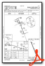
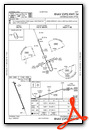
Instrument Approach Procedure (IAP) Charts
Nearby Airports with Instrument Procedures
| ID | Name | Heading / Distance | ||
|---|---|---|---|---|
 |
4C8 | Albia Municipal Airport | 018° | 19.7 |
|
4K6 | Bloomfield Municipal Airport | 082° | 21.8 |
|
KCNC | Chariton Municipal Airport | 314° | 29.0 |
|
KOTM | Ottumwa Regional Airport | 039° | 32.7 |
|
03D | Memphis Memorial Airport | 114° | 33.9 |
|
KOOA | Oskaloosa Municipal Airport | 029° | 37.4 |
|
KOXV | Knoxville Municipal Airport | 345° | 38.1 |
|
KIRK | Kirksville Regional Airport | 155° | 39.0 |
|
I75 | Osceola Municipal Airport | 301° | 42.1 |
|
KPEA | Pella Municipal Airport | 357° | 43.0 |
|
KLWD | Lamoni Municipal Airport | 266° | 45.8 |
|
KFFL | Fairfield Municipal Airport | 061° | 47.4 |
Airport Images
Do you have a recent image of this airport? Upload it here!


