Login
Register
UIN
Quincy Regional-Baldwin Field Airport
Official FAA Data Effective 2026-02-19 0901Z
VFR Chart of KUIN
Sectional Charts at SkyVector.com
IFR Chart of KUIN
Enroute Charts at SkyVector.com
Location Information for KUIN
Coordinates: N39°56.54' / W91°11.54'Located 10 miles E of Quincy, Illinois on 1101 acres of land. View all Airports in Illinois.
Surveyed Elevation is 768 feet MSL.
Operations Data
|
|
Airport Communications
| ASOS: | 121.425 Tel. 217-885-3319 |
|---|---|
| UNICOM: | 123.000 |
| CTAF: | 123.000 |
| AWOS-3PT at HAE (17.4 SW): | 120.775 573-600-5226 |
| AWOS-3PT at I63 (18.2 E): | 118.325 217-773-4082 |
| AWOS-3T at PPQ (26.3 SE): | 118.525 217-285-1428 |
- APCH/DEP SVC PRVDD BY KANSAS CITY ARTCC ON FREQS 126.225/317.775 (QUINCY RCAG).
Nearby Navigation Aids
|
| ||||||||||||||||||||||||||||||||||||||||||||||||||||||||||||
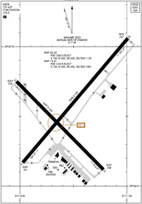
Runway 04/22
| Dimensions: | 7098 x 150 feet / 2163 x 46 meters | |
|---|---|---|
| Surface: | Asphalt / Grooved in Excellent Condition | |
| Weight Limits: | S-120, D-250, ST-550, DT-1120
PCR VALUE: 1500/F/D/X/T
| |
| Edge Lighting: | High Intensity | |
| Runway 04 | Runway 22 | |
| Coordinates: | N39°56.17' / W91°11.97' | N39°57.06' / W91°10.99' |
| Elevation: | 760.9 | 746.8 |
| Traffic Pattern: | Left | Left |
| Runway Heading: | 40° True | 220° True |
| Declared Distances: | TORA:7098 TODA:7098 ASDA:7098 LDA:7098 | TORA:7098 TODA:7098 ASDA:7098 LDA:7098 |
| Markings: | Precision Instrument in good condition. | Precision Instrument in good condition. |
| Glide Slope Indicator | P4R (3.00° Glide Path Angle) | P4L (3.00° Glide Path Angle) |
| Approach Lights: | MALSR 1,400 Foot Medium-intensity Approach Lighting System with runway alignment indicator lights. | |
| REIL: | Yes | |
| Obstacles: | 16 ft Road 848 ft from runway, 586 ft right of center | |
Runway 13/31
| Dimensions: | 5397 x 150 feet / 1645 x 46 meters | |
|---|---|---|
| Surface: | Asphalt / Grooved in Fair Condition | |
| Weight Limits: | S-120, D-250, ST-550, DT-1081
PCR VALUE: 1310/F/D/X/T
| |
| Edge Lighting: | Medium Intensity | |
| Runway 13 | Runway 31 | |
| Coordinates: | N39°56.75' / W91°12.03' | N39°56.12' / W91°11.22' |
| Elevation: | 765.2 | 768.4 |
| Traffic Pattern: | Left | Left |
| Runway Heading: | 135° True | 315° True |
| Declared Distances: | TORA:5397 TODA:5397 ASDA:5123 LDA:5123 | TORA:5397 TODA:5397 ASDA:5146 LDA:5146 |
| Markings: | Non-Precision Instrument in good condition. | Non-Precision Instrument in good condition. |
| Glide Slope Indicator | P4L (3.00° Glide Path Angle) PAPI UNUSBL BYD 9 DEGS RIGHT OF CNTRLN. | P4R (3.00° Glide Path Angle) |
| Obstacles: | 11 ft Road 525 ft from runway, 300 ft right of center | 15 ft Pole 800 ft from runway, 200 ft left of center |
Services Available
| Fuel: | 100LL (blue), Jet-A |
|---|---|
| Transient Storage: | Tiedowns |
| Airframe Repair: | MAJOR |
| Engine Repair: | MAJOR |
| Bottled Oxygen: | NOT AVAILABLE |
| Bulk Oxygen: | NOT AVAILABLE |
| Other Services: | AIR AMBULANCE SERVICES,CHARTER SERVICE,PILOT INSTRUCTION,AIRCRAFT RENTAL |
Ownership Information
| Ownership: | Publicly owned | |
|---|---|---|
| Owner: | CITY OF QUINCY | |
| 1645 HWY 104 | ||
| QUINCY, IL 62305 | ||
| 217-885-3285 | EXT: 8. | |
| Manager: | BILL LANTZ | EMAIL ADDRESS: QUINCYAIRPORT@QUINCYIL.GOV |
| 1645 HWY 104 | ||
| QUINCY, IL 62305 | ||
| 217-885-3285 | ||
Other Remarks
- MIGRATORY WATERFOWL ON & INVOF ARPT.
- FICONS NOT MONITORED DAILY BTWN 2100-0500 LCL HRS.
- ARPT WDI OTS INDEFLY.
- USE CTN; NO LINE OF SIGHT BTWN RWY ENDS DUE TO TOPOGRAPHY AND BLDG OBSTNS; ALL DEP/ARR ACFT USE CTAF 123.0.
- FOR CD IF UNA TO CTC ON FSS FREQ, CTC KANSAS CITY ARTCC AT 913-254-8508.
- ARFF NOT AVBL 24 HRS. 24 HRS PPR FOR UNSKED ACFT OPS; CTC ARPT MGR 217-885-3285 OR 217-885-3262.
- RWY 04 IS THE PREFERRED RWY IN CALM WIND CONDITIONS.
- ACTVT MALSR RWY 04; REIL RWY 22; PAPI RWY 13, 31, 04 & 22; HIRL RWY 04/22; MIRL RWY 13/31 - CTAF. HIRL RWY 04/22 PRESET LOW INTST; TO INCR INTST - CTAF.
Weather Minimums
Instrument Approach Procedure (IAP) Charts
Nearby Airports with Instrument Procedures
| ID | Name | Heading / Distance | ||
|---|---|---|---|---|
 |
KHAE | Hannibal Regional Airport | 221° | 17.4 |
 |
I63 | Mount Sterling Municipal Airport | 081° | 18.1 |
 |
6M6 | Lewis County Regional Airport | 296° | 25.0 |
 |
KPPQ | Pittsfield Penstone Municipal Airport | 133° | 26.4 |
 |
K52 | Cpt Ben Smith Airfield/Monroe City Airport | 233° | 30.9 |
 |
KEOK | Keokuk Municipal Airport | 340° | 32.9 |
 |
H19 | Bowling Green Municipal Airport | 182° | 34.3 |
 |
KMQB | Macomb Municipal Airport | 035° | 42.6 |
 |
KFSW | Fort Madison Municipal Airport | 351° | 43.4 |
 |
KIJX | Jacksonville Municipal Airport | 102° | 45.2 |
 |
KBRL | Southeast Iowa Regional Airport | 003° | 50.5 |
 |
KMYJ | Mexico Memorial Airport | 211° | 55.3 |


