Login
Register


VAY
South Jersey Regional Airport
Official FAA Data Effective 2025-12-25 0901Z
Chart Supplement

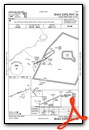
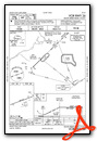
VFR Chart of KVAY
Sectional Charts at SkyVector.com
IFR Chart of KVAY
Enroute Charts at SkyVector.com
Location Information for KVAY
Coordinates: N39°56.57' / W74°50.74'Located 04 miles SW of Mount Holly, New Jersey on 642 acres of land. View all Airports in New Jersey.
Surveyed Elevation is 52 feet MSL.
Operations Data
|
|
Airport Communications
| ASOS: | 119.325 Tel. 609-267-1176 |
|---|---|
| MC GUIRE APPROACH: | 126.475 363.8 |
| MC GUIRE DEPARTURE: | 126.475 363.8 |
| UNICOM: | 122.800 |
| CTAF: | 122.800 |
| ATIS at PNE (11.3 NW): | 121.15 |
| ASOS at PNE (11.3 NW): | 215-897-9068 |
| D-ATIS at WRI (12.5 E): | 110.6 |
Nearby Navigation Aids
|
| ||||||||||||||||||||||||||||||||||||||||||||||||||||||||||||


Runway 08/26
| Dimensions: | 3881 x 50 feet / 1183 x 15 meters | |
|---|---|---|
| Surface: | Asphalt in Good Condition | |
| Weight Limits: | S-30 | |
| Edge Lighting: | Medium Intensity | |
| Runway 08 | Runway 26 | |
| Coordinates: | N39°56.46' / W74°51.13' | N39°56.68' / W74°50.36' |
| Elevation: | 43.8 | 51.8 |
| Traffic Pattern: | Left | Right |
| Runway Heading: | 70° True | 250° True |
| Markings: | Non-Precision Instrument in fair condition. | Non-Precision Instrument in fair condition. |
| Glide Slope Indicator | P2R (3.25° Glide Path Angle) | P2R (3.00° Glide Path Angle) |
| REIL: | Yes | Yes |
| Obstacles: | 54 ft Tree 550 ft from runway, 170 ft right of center | 45 ft Tree 909 ft from runway, 99 ft left of center |
Services Available
| Fuel: | 100LL (blue), Jet-A |
|---|---|
| Transient Storage: | Hangars,Tiedowns |
| Airframe Repair: | MAJOR |
| Engine Repair: | MAJOR |
| Bottled Oxygen: | NONE |
| Bulk Oxygen: | NONE |
| Other Services: | AIR AMBULANCE SERVICES,PILOT INSTRUCTION |
Ownership Information
| Ownership: | Publicly owned | |
|---|---|---|
| Owner: | N.J. DEPT. OF TRANSPORTATION | |
| 1035 PARKWAY AVE., P.O. BOX 600 | ||
| TRENTON, NJ 08625-0600 | ||
| 609-530-2900 | ||
| Manager: | MINDY KIMBALL | |
| 68 STACY HAINES RD. | ||
| LUMBERTON, NJ 08048 | ||
| 609-267-3131 | ||
Other Remarks
- TREES ALONG SIDES OF RY PRIMARILY NW.
- BALLS MKG PLINES ON APH TO RY 08 FADED.
- DEER ON & INVOF ARPT.
- HELICOPTER TAKEOFFS AND LANDINGS RESTRICTED TO RY 08/26 ONLY.
- PARALLEL TAXIWAY NON-STANDARD WIDTH, 18 FT ASP.
- AVOID OVERFLYING HOUSING AREA WNW OF ARPT BELOW 300 FT WHEN IN THE TRAFFIC PATTERN FOR RWY 8.
- FOR CD CTC MC GUIRE APCH AT 609-754-2767.
- JET A AVAILABLE 24-HOUR SELF SERVICE WITH CREDIT CARD OR TRUCK DURING ATTENDED HOURS.
- ACTVT MIRL RY 08/26 AND REIL RY 08 & 26 -123.3.
Weather Minimums
Standard Terminal Arrival (STAR) Charts

Instrument Approach Procedure (IAP) Charts

Nearby Airports with Instrument Procedures
| ID | Name | Heading / Distance | ||
|---|---|---|---|---|
 |
N14 | Flying W Airport | 106° | 1.9 |
|
19N | Pine Valley Airport | 205° | 10.9 |
|
KPNE | Northeast Philadelphia Airport | 317° | 11.3 |
|
KWRI | Mc Guire Field (Joint Base Mc Guire Dix Lakehurst) Airport | 069° | 12.5 |
|
17N | Cross Keys Airport | 211° | 16.7 |
|
N81 | Hammonton Municipal Airport | 166° | 17.0 |
|
KPHL | Philadelphia International Airport | 257° | 18.7 |
|
N87 | Trenton-Robbinsville Airport | 034° | 19.8 |
|
KTTN | Trenton Mercer Airport | 004° | 20.1 |
|
KLOM | Wings Field Airport | 301° | 22.6 |
|
KNEL | Lakehurst Maxfield Field Airport | 076° | 23.5 |
|
KMJX | Ocean County Airport | 092° | 25.4 |
Airport Images
Do you have a recent image of this airport? Upload it here!


