Login
Register


VLL
Oakland/Troy Airport
Official FAA Data Effective 2025-12-25 0901Z
Chart Supplement

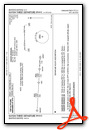
VFR Chart of KVLL
Sectional Charts at SkyVector.com
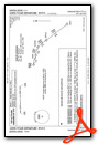
IFR Chart of KVLL
Enroute Charts at SkyVector.com
Location Information for KVLL
Coordinates: N42°32.58' / W83°10.67'Located 02 miles E of Troy, Michigan on 119 acres of land. View all Airports in Michigan.
Surveyed Elevation is 727 feet MSL.
Operations Data
|
|
Airport Communications
| AWOS-3: | 119.475 Tel. 248-288-4649 |
|---|---|
| DETROIT APPROACH: | 132.35 284.0 |
| DETROIT DEPARTURE: | 132.35 284.0 |
| UNICOM: | 123.050 |
| CTAF: | 123.050 |
| ATIS at DET (10.8 SE): | 124.875 |
| ASOS at DET (11.1 SE): | 313-371-9696 |
| ATIS at PTK (13.0 NW): | 125.025 |
Nearby Navigation Aids
|
| ||||||||||||||||||||||||||||||||||||||||||||||||||||||


Runway 10/28
| Dimensions: | 3549 x 60 feet / 1082 x 18 meters | |
|---|---|---|
| Surface: | Asphalt in Excellent Condition | |
| Edge Lighting: | Medium Intensity | |
| Runway 10 | Runway 28 | |
| Coordinates: | N42°32.58' / W83°11.07' | N42°32.58' / W83°10.28' |
| Elevation: | 727.0 | 701.0 |
| Traffic Pattern: | Left | Left |
| Runway Heading: | 90° True | 270° True |
| Markings: | Non-Precision Instrument in good condition. | Non-Precision Instrument in good condition. |
| Glide Slope Indicator | P2R (3.75° Glide Path Angle) | P2L (3.75° Glide Path Angle) |
| Obstacles: | 23 ft Tree 200 ft from runway, 160 ft left of center CTLG OBSTN EXCEEDS A 45 DEG SLP. |
18 ft Tree 200 ft from runway, 175 ft left of center CTLG OBSTN EXCEEDS A 45 DEG SLP. |
Services Available
| Fuel: | 100LL (blue), Jet A+ |
|---|---|
| Transient Storage: | Hangars,Tiedowns FOR TSNT HNGR STORAGE CTC AMGR. |
| Airframe Repair: | NONE |
| Engine Repair: | NONE |
| Bottled Oxygen: | NOT AVAILABLE |
| Bulk Oxygen: | NOT AVAILABLE |
| Other Services: | PILOT INSTRUCTION,AIRCRAFT RENTAL |
Ownership Information
| Ownership: | Publicly owned | |
|---|---|---|
| Owner: | OAKLAND COUNTY | |
| 6500 PATTERSON PKWY | ||
| WATERFORD, MI 48327-1683 | ||
| 248-666-3900 | ||
| Manager: | CHERYL BUSH | |
| 6500 PATTERSON PKWY | ARPT PHYS ADS: 2672 INDUSTRIAL ROW DR, TROY, MI 48084. | |
| WATERFORD, MI 48327-1683 | ||
| 248-666-3900 | ||
Other Remarks
- DEER & LRG BIRDS ON & INVOF ARPT.
- NO TGL OR PRACTICE TFC PATTERNS.
- FOR CD CTC DETROIT APCH AT 734-955-1404.
- ACTVT PAPI RWY 10 & 28; MIRL RWY 10/28 - CTAF.
Weather Minimums

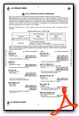
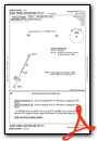
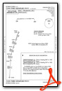
Standard Terminal Arrival (STAR) Charts
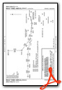
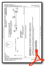
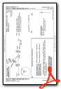
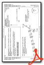
Instrument Approach Procedure (IAP) Charts

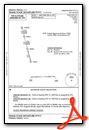
Departure Procedure (DP) Charts


Nearby Airports with Instrument Procedures
| ID | Name | Heading / Distance | ||
|---|---|---|---|---|
 |
KDET | Coleman A Young Municipal Airport | 136° | 10.8 |
|
KPTK | Oakland County International Airport | 304° | 13.0 |
|
KMTC | Selfridge Angb Airport | 074° | 15.7 |
|
1D2 | Canton-Plymouth-Mettetal Airport | 226° | 17.0 |
|
57D | Ray Community Airport | 047° | 17.3 |
|
D98 | Romeo State Airport | 030° | 17.7 |
|
CYQG | Windsor Airport | 148° | 18.8 |
|
Y47 | Oakland Southwest Airport | 263° | 19.9 |
|
KDTW | Detroit Metro Wayne County Airport | 201° | 21.3 |
|
KYIP | Willow Run Airport | 221° | 24.0 |
|
KONZ | Grosse Ile Municipal Airport | 178° | 26.6 |
|
9G2 | Prices Airport | 301° | 30.6 |
Airport Images
Do you have a recent image of this airport? Upload it here!


