Login
Register


VMR
Harold Davidson Field Airport
Official FAA Data Effective 2026-02-19 0901Z
Chart Supplement

VFR Chart of KVMR
Sectional Charts at SkyVector.com
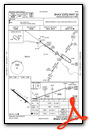
IFR Chart of KVMR
Enroute Charts at SkyVector.com
Location Information for KVMR
Coordinates: N42°45.92' / W96°56.06'Located 01 miles S of Vermillion, South Dakota on 140 acres of land. View all Airports in South Dakota.
Surveyed Elevation is 1146 feet MSL.
Operations Data
|
|
Airport Communications
| AWOS-3P: | 118.650 |
|---|---|
| SIOUX CITY APPROACH: | 124.6 307.0 |
| SIOUX CITY DEPARTURE: | 124.6 307.0 |
| CTAF: | 122.800 |
| UNICOM: | 122.800 |
| AWOS-3PT at YKN (21.9 NW): | 119.05 605-665-6072 |
| AWOS-3 at LCG (31.5 S): | 120.125 402-375-0111 |
| AWOS-3P at LRJ (32.6 E): | 120.975 712-546-8439 |
- APCH/DEP SVC PRVDD BY MINNEAPOLIS ARTCC ON FREQS 125.025/235.625 (SIOUX CITY RCAG) WHEN SIOUX CITY APCH CTL CLSD.
- COMMUNICATIONS PRVDD BY HURON RADIO ON FREQ 122.4 (YANKTON RCO).
Nearby Navigation Aids
|
| ||||||||||||||||||||||||||||||||||||||||||||||||||||||||||||


Runway 12/30
| Dimensions: | 4105 x 75 feet / 1251 x 23 meters | |
|---|---|---|
| Surface: | Concrete in Excellent Condition | |
| Weight Limits: | S-12 | |
| Edge Lighting: | Medium Intensity | |
| Runway 12 | Runway 30 | |
| Coordinates: | N42°46.12' / W96°56.43' | N42°45.72' / W96°55.68' |
| Elevation: | 1144.9 | 1145.2 |
| Traffic Pattern: | Right | Left |
| Runway Heading: | 126° True | 306° True |
| Markings: | Non-Precision Instrument in fair condition. | Non-Precision Instrument in fair condition. |
| Glide Slope Indicator | P2L (3.00° Glide Path Angle) | P2L (3.00° Glide Path Angle) |
| Obstacles: | 70 ft Trees 1900 ft from runway | |
Services Available
| Fuel: | 100LL (blue), Jet-A |
|---|---|
| Transient Storage: | Hangars,Tiedowns |
| Airframe Repair: | MAJOR |
| Engine Repair: | MAJOR |
| Bottled Oxygen: | NONE |
| Bulk Oxygen: | NONE |
| Other Services: | CROP DUSTING SERVICES,PILOT INSTRUCTION,AIRCRAFT RENTAL |
Ownership Information
| Ownership: | Publicly owned | |
|---|---|---|
| Owner: | CITY OF VERMILLION | |
| 25 CENTER ST. | ||
| VERMILLION, SD 57069 | ||
| (605) 677-7050 | ||
| Manager: | DENNY MARTENS | |
| 25 CENTER ST. | ||
| VERMILLION, SD 57069 | ||
| 605-677-8159 | ||
Other Remarks
- WATERFOWL AND BIRDS ON AND INVOF ARPT.
- FOR CD CTC SIOUX CITY APCH AT 712-293-2482. WHEN SIOUX CITY APCH CLSD, FOR CD CTC MINNEAPOLIS ARTCC AT 651-463-5588.
- FUEL AVBL 24 HRS WITH CREDIT CARD.
- ACTVT PAPI RWY 12 & 30; MIRL RWY 12/30 - CTAF.
- AUTOMATED UNICOM.
Weather Minimums

Instrument Approach Procedure (IAP) Charts

Nearby Airports with Instrument Procedures
| ID | Name | Heading / Distance | ||
|---|---|---|---|---|
 |
0B4 | Hartington Municipal/Bud Becker Field Airport | 235° | 17.2 |
|
KYKN | Chan Gurney Municipal Airport | 294° | 21.9 |
|
KLCG | Wayne Municipal/Stan Morris Field Airport | 183° | 31.5 |
|
KLRJ | Le Mars Municipal Airport | 088° | 32.7 |
|
KSUX | Sioux Gateway/Brig General Bud Day Field Airport | 131° | 32.7 |
|
KSXK | Sioux County Regional Airport | 068° | 36.6 |
|
0C4 | Pender Municipal Airport | 166° | 40.2 |
|
6K3 | Creighton Municipal Airport | 247° | 45.7 |
|
KFSD | Joe Foss Field Airport | 009° | 49.7 |
|
KOFK | Norfolk Regional/Karl Stefan Memorial Field Airport | 205° | 51.8 |
|
KRRQ | Rock Rapids Municipal Airport | 038° | 52.9 |
|
KSHL | Sheldon Regional Airport | 060° | 55.3 |
Airport Images
Do you have a recent image of this airport? Upload it here!


