Login
Register


WDG
Enid Woodring Regional Airport
Official FAA Data Effective 2026-01-22 0901Z
Chart Supplement

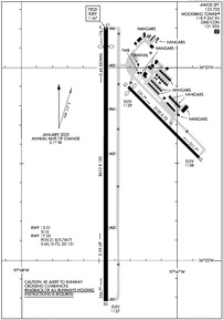
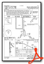
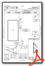
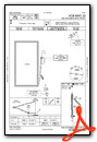
KWDG Airport Diagram
VFR Chart of KWDG
Sectional Charts at SkyVector.com
IFR Chart of KWDG
Enroute Charts at SkyVector.com
Location Information for KWDG
Coordinates: N36°22.56' / W97°47.37'Located 04 miles SE of Enid, Oklahoma on 1256 acres of land. View all Airports in Oklahoma.
Surveyed Elevation is 1167 feet MSL.
Operations Data
|
|
Airport Communications
| AWOS-3PT: | 123.725 Tel. 580-237-1475 |
|---|---|
| WOODRING TOWER: | 118.9 257.95 |
| WOODRING GROUND: | 121.925 |
| VANCE APPROACH: | 121.3 346.325 |
| VANCE DEPARTURE: | 121.3 346.325 |
| CTAF: | 118.900 |
| EMERG: | 121.5 |
| ATIS at END (6.6 W): | 115.4 |
| AWOS-3PT at BKN (30.7 NE): | 120.575 580-363-0688 |
| AWOS-3PT at 6K4 (33.5 W): | 120.00 |
- APCH/DEP CTL SVC PRVDD BY KANSAS CITY ARTCC (ZKC) ON FREQS 127.8/319.1 (PONCA CITY RCAG) WHEN VANCE APCH CTL (END) CLSD.
Nearby Navigation Aids
|
| ||||||||||||||||||||||||||||||||||||||||||||||||||||||||||||


Runway 17/35
| Dimensions: | 8613 x 100 feet / 2625 x 30 meters | |
|---|---|---|
| Surface: | Concrete / Grooved in Good Condition | |
| Weight Limits: | 21 /R/C/W/T, S-60, D-73, ST-131 | |
| Edge Lighting: | Medium Intensity | |
| Runway 17 | Runway 35 | |
| Coordinates: | N36°23.21' / W97°47.46' | N36°21.79' / W97°47.47' |
| Elevation: | 1167.1 | 1137.3 |
| Traffic Pattern: | Left | Right |
| Runway Heading: | 180° True | 0 |
| Displaced Threshold: | 611 Feet | |
| Declared Distances: | TORA:8613 TODA:8613 ASDA:8613 LDA:8002 | TORA:8002 TODA:8002 ASDA:8002 LDA:8002 |
| Markings: | Precision Instrument in good condition. | Precision Instrument in good condition. |
| Glide Slope Indicator | P4L (3.00° Glide Path Angle) | P4L (3.00° Glide Path Angle) |
| Approach Lights: | MALSR 1,400 Foot Medium-intensity Approach Lighting System with runway alignment indicator lights. | |
| REIL: | Yes | |
| Obstacles: | 20 ft Road 284 ft from runway, 512 ft left of center OBSTN CLC SLOPE 44:1 TO DISP THLD. |
|
Runway 13/31
| Dimensions: | 3150 x 75 feet / 960 x 23 meters | |
|---|---|---|
| Surface: | Concrete in Excellent Condition | |
| Weight Limits: | S-16 | |
| Edge Lighting: | Medium Intensity | |
| Runway 13 | Runway 31 | |
| Coordinates: | N36°22.90' / W97°47.32' | N36°22.53' / W97°46.87' |
| Elevation: | 1158.8 | 1158.1 |
| Traffic Pattern: | Left | Right |
| Runway Heading: | 135° True | 315° True |
| Displaced Threshold: | 112 Feet | |
| Declared Distances: | TORA:3150 TODA:3150 ASDA:3150 LDA:3038 | TORA:3150 TODA:3150 ASDA:3038 LDA:3038 |
| Markings: | Non-Precision Instrument in good condition. | Non-Precision Instrument in good condition. |
| Glide Slope Indicator | P2L (3.00° Glide Path Angle) | P2L (3.00° Glide Path Angle) |
Services Available
| Fuel: | 100LL (blue), Jet A+ |
|---|---|
| Transient Storage: | Hangars,Tiedowns |
| Airframe Repair: | MINOR |
| Engine Repair: | MINOR |
| Bottled Oxygen: | NONE |
| Bulk Oxygen: | HIGH/LOW 2100 LBS |
| Other Services: | AIR FREIGHT SERVICES,PILOT INSTRUCTION,AIRCRAFT RENTAL |
Ownership Information
| Ownership: | Publicly owned | |
|---|---|---|
| Owner: | CITY OF ENID | |
| PO BOX 1768 | ||
| ENID, OK 73702 | ||
| 580-234-0400 | ||
| Manager: | KESTON COOK | |
| 1026 SOUTH 66TH STREET | ||
| ENID, OK 73701 | ||
| 580-616-7386 | ||
Other Remarks
- MIL JET TRNG DRG DALGT HRS INVOF ARPT.
- NOISE SENSITIVE AREA 3/4NM NW. ALL ACFT DEP RWY 35 CLIMB 500FT AGL PRIOR TO TURNING CROSSWIND TO WEST.
- FOR CD CTC VANCE APCH C580-213-6765. WHEN VANCE APCH CLSD, CTC KANSAS CITY ARTCC 913-254-8508.
- 0LL FUEL AVBL 24 HRS. SELF SVC AVGAS AVBL. FOR JET A FUEL AFT HRS CALL(580) 231-0189.
- WHEN ATCT CLSD ACTVT MALSR RWY 35; REIL RWY 17; MIRL RWY 17/35 & 13/31 - CTAF. PAPI RWY 17 & 35, 13 & 31 OPER CONSLY.
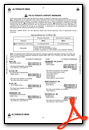
Weather Minimums

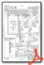
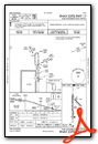
Instrument Approach Procedure (IAP) Charts
Nearby Airports with Instrument Procedures
| ID | Name | Heading / Distance | ||
|---|---|---|---|---|
 |
KEND | Vance AFB Airport | 250° | 6.6 |
|
F22 | Perry Municipal Airport | 088° | 24.8 |
|
O53 | Medford Municipal Airport | 004° | 24.9 |
|
KBKN | Blackwell-Tonkawa Municipal Airport | 043° | 30.7 |
|
6K4 | Fairview Municipal Airport | 261° | 33.7 |
|
KGOK | Guthrie/Edmond Regional Airport | 149° | 36.3 |
|
KSWO | Stillwater Regional Airport | 110° | 36.5 |
|
KPNC | Ponca City Regional Airport | 057° | 39.6 |
|
KJWG | Watonga Regional Airport | 225° | 43.4 |
|
KHSD | Sundance Airport | 174° | 46.6 |
|
KAVK | Alva Regional Airport | 299° | 48.8 |
|
KANY | Anthony Municipal Airport | 343° | 49.0 |
Fuel Providers

Airport Images

By: Big Orange Bird

By: scott.fouts@yah...


