Login
Register


LHX
La Junta Municipal Airport
Official FAA Data Effective 2026-02-19 0901Z
Chart Supplement

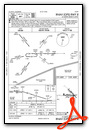
VFR Chart of KLHX
Sectional Charts at SkyVector.com
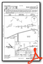
IFR Chart of KLHX
Enroute Charts at SkyVector.com
Location Information for KLHX
Coordinates: N38°3.00' / W103°30.58'Located 03 miles N of La Junta, Colorado on 4200 acres of land. View all Airports in Colorado.
Surveyed Elevation is 4228 feet MSL.
Operations Data
|
|
Airport Communications
| ASOS: | 135.525 Tel. 719-384-5961 |
|---|---|
| UNICOM: | 123.000 |
| CTAF: | 123.000 |
| ASOS at LAA (38.9 E): | 135.625 719-336-3854 |
| ATIS at PUB (48.8 W): | 125.25 |
| ASOS at PUB (49.1 W): | 719-225-7029 |
- APCH/DEP CTL SVC PRVDD BY DENVER ARTCC (ZDV) ON FREQS 128.375/379.95 (PUEBLO RCAG).
Nearby Navigation Aids
|
| ||||||||||||||||||||||||||||||||||||||||||||||||


Runway 08/26
| Dimensions: | 6849 x 75 feet / 2088 x 23 meters | |
|---|---|---|
| Surface: | Asphalt in Good Condition | |
| Weight Limits: | S-30, D-50, ST-90 | |
| Edge Lighting: | Medium Intensity | |
| Runway 08 | Runway 26 | |
| Coordinates: | N38°2.89' / W103°31.40' | N38°2.89' / W103°29.97' |
| Elevation: | 4228.6 | 4153.8 |
| Traffic Pattern: | Left | Left |
| Runway Heading: | 90° True | 270° True |
| Markings: | Non-Precision Instrument in good condition. | Non-Precision Instrument in good condition. |
| Glide Slope Indicator | P2L (3.00° Glide Path Angle) | P2L (3.00° Glide Path Angle) |
| REIL: | Yes | Yes |
| Obstacles: | 28 ft Road 1351 ft from runway, 8 ft right of center | |
Runway 12/30
| Dimensions: | 5803 x 60 feet / 1769 x 18 meters | |
|---|---|---|
| Surface: | Asphalt-Concrete in Poor Condition RWY SFC RAVELING WITH FOD POTENTIAL. | |
| Weight Limits: | S-50, D-65, ST-100 | |
| Runway 12 | Runway 30 | |
| Coordinates: | N38°3.47' / W103°30.89' | N38°2.79' / W103°30.04' |
| Elevation: | 4185.7 | 4157.9 |
| Traffic Pattern: | Left | Left |
| Runway Heading: | 135° True | 315° True |
| Markings: | Basic in fair condition. | Basic in fair condition. |
Helipad H1
| Dimensions: | 145 x 145 feet / 44 x 44 meters | |
|---|---|---|
| Surface: | Asphalt in Fair Condition | |
| Coordinates: | N38°2.77' / W103°30.85' | N0°0.00' / E0°0.00' |
| Elevation: | 4197.0 | |
| Markings: | Basic in poor condition. | |
Services Available
| Fuel: | 100LL (blue), Jet-A |
|---|---|
| Transient Storage: | Hangars,Tiedowns |
| Airframe Repair: | NOT AVAILABLE |
| Engine Repair: | NOT AVAILABLE |
| Bottled Oxygen: | NONE |
| Bulk Oxygen: | NOT AVAILABLE |
| Other Services: | CROP DUSTING SERVICES,AIR AMBULANCE SERVICES,PILOT INSTRUCTION |
Ownership Information
| Ownership: | Publicly owned | |
|---|---|---|
| Owner: | CITY OF LA JUNTA | |
| PO BOX 489 | ||
| LA JUNTA, CO 81050 | ||
| 719-384-8407 | ||
| Manager: | BROCK HINKHOUSE | ALT CTC FBO 719-384-8407. |
| P O BOX 489 | ||
| LA JUNTA, CO 81050 | ||
| 719-363-1253 | ||
Other Remarks
- THIS AIRPORT HAS BEEN SURVEYED BY THE NATIONAL GEODETIC SURVEY.
- ANTELOPE ON & INVOF ARPT.
- HVY AGRICULTURAL OPNS DURG SUMMER MONTHS.
- RWY 12/30 HAS LOOSE ASPH MTRL IN PRIM SFC WEST SIDE OF RWY FULL LENGTH.
- RWY 12/30 EDGE UNDEFINED.
- BE ALERT; INTENSIVE USAF STUDENT TRNG INVOF COLORADO SPRINGS & PUEBLO COLORADO.
- SELF SERVE JET-A NOT AVAIL.
- FOR CD CTC DENVER ARTCC AT 303-651-4257.
- ACTVT REIL RWY 08 & 26; PAPI RWY 08 & 26; MIRL RWY 08/26 - CTAF.
Weather Minimums
Instrument Approach Procedure (IAP) Charts
Nearby Airports with Instrument Procedures
| ID | Name | Heading / Distance | ||
|---|---|---|---|---|
 |
KLAA | Southeast Colorado Regional Airport | 088° | 38.9 |
|
KPUB | Pueblo Memorial Airport | 287° | 48.9 |
|
8V7 | Springfield Municipal Airport | 129° | 55.3 |
|
KTAD | Perry Stokes Airport | 220° | 61.8 |
|
4V1 | Spanish Peaks Airfield Airport | 251° | 64.2 |
|
KCOS | City of Colorado Springs Municipal Airport | 309° | 72.1 |
|
KFLY | Meadow Lake Airport | 317° | 73.2 |
|
KLIC | Limon Municipal Airport | 354° | 73.8 |
|
1V6 | Fremont County Airport | 287° | 78.8 |
|
3K3 | Syracuse-Hamilton County Municipal Airport | 091° | 83.6 |
|
5K2 | Tribune Municipal Airport | 073° | 86.6 |
|
KJHN | Stanton County Municipal Airport | 107° | 89.0 |
Airport Images
Do you have a recent image of this airport? Upload it here!


