Login
Register


LIC
Limon Municipal Airport
Official FAA Data Effective 2026-01-22 0901Z
Chart Supplement

VFR Chart of KLIC
Sectional Charts at SkyVector.com
IFR Chart of KLIC
Enroute Charts at SkyVector.com
Location Information for KLIC
Coordinates: N39°16.49' / W103°39.95'Located 01 miles NE of Limon, Colorado on 419 acres of land. View all Airports in Colorado.
Surveyed Elevation is 5374 feet MSL.
Operations Data
|
|
Airport Communications
| ASOS: | 121.125 Tel. 719-775-0515 |
|---|---|
| CTAF: | 122.900 |
| AWOS-3 at MNH (45.4 W): | 134.375 303-648-3479 |
| AWOS-3PT at FLY (46.5 SW): | 118.450 719-683-5371 |
| AWOS-3 at CFO (50.6 NW): | 119.025 303-261-9104 |
- APCH/DEP CTL SVC PRVDD BY DENVER ARTCC (ZDV) ON FREQS 133.4/377.175 (DENVER RCAG).
Nearby Navigation Aids
|
| ||||||||||||||||||||||||||||||||||||||||||||||||||||||


Runway 16/34
3000 FT TWY LEADING TO S END OF RWY 16. | ||
| Dimensions: | 4700 x 60 feet / 1433 x 18 meters | |
|---|---|---|
| Surface: | Concrete in Fair Condition | |
| Weight Limits: | S-12 | |
| Edge Lighting: | Medium Intensity | |
| Runway 16 | Runway 34 | |
| Coordinates: | N39°16.87' / W103°40.04' | N39°16.11' / W103°39.86' |
| Elevation: | 5374.4 | 5348.6 |
| Traffic Pattern: | Left | Left |
| Runway Heading: | 169° True | 349° True |
| Markings: | Basic in good condition. | Basic in good condition. |
| Glide Slope Indicator | P2L (3.00° Glide Path Angle) | P2L (3.00° Glide Path Angle) |
Services Available
| Fuel: | 100LL (blue) |
|---|---|
| Transient Storage: | Tiedowns |
| Airframe Repair: | MINOR |
| Engine Repair: | MINOR |
| Bottled Oxygen: | NOT AVAILABLE |
| Bulk Oxygen: | NOT AVAILABLE |
| Other Services: | PILOT INSTRUCTION |
Ownership Information
| Ownership: | Publicly owned | |
|---|---|---|
| Owner: | TOWN OF LIMON | |
| TOWN HALL, BOX 9 | ||
| LIMON, CO 80828 | ||
| 719-775-2346 | ||
| Manager: | GREG TACHA | |
| TOWN OF LIMON, BOX 9 | ||
| LIMON, CO 80828 | ||
| 719-775-2346 | ||
Other Remarks
- CTN: UNCTLD VEHICLE ACES.
- TWY MKD WITH BLUE REFLECTORS.
- DEER ON & INVOF ARPT.
- CTN: MIL STUDENT TRNG INVOF COLORADO SPRINGS & PUEBLO COLORADO.
- FOR CD IF UNA TO CTC ON FSS FREQ, CTC DENVER ARTCC AT 303-651-4257.
- PAJA ON & INVOF ARPT; MIDFIELD OVR FLT NA.
- +18 FT ROAD 820 FT FM THR OB; +4 FT FENCE 785 FT FM THR OB; +22 FT SIGN 918 FT FM RWY END ON CNTRLN; +45 FT TREES 62 FT LT OF CTLN, 1430 FT FM RWY END OB; +51 FT TANK 1455 FT FM THR 150 R OF CNTRLN.
- 0LL AVBL H24 WITH CREDIT CARD.
- ACTVT PAPI RWY 16 & 34; MIRL RWY 16/34 - CTAF.
Weather Minimums

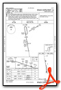
Instrument Approach Procedure (IAP) Charts

Nearby Airports with Instrument Procedures
| ID | Name | Heading / Distance | ||
|---|---|---|---|---|
 |
KFLY | Meadow Lake Airport | 245° | 46.7 |
|
KCFO | Colorado Air and Space Port Airport | 307° | 50.7 |
|
KCOS | City of Colorado Springs Municipal Airport | 240° | 56.0 |
|
KBKF | Buckley Space Force Base Airport | 297° | 56.6 |
|
KAPA | Centennial Airport | 288° | 57.8 |
|
KAKO | Colorado Plains Regional Airport | 020° | 57.8 |
|
KDEN | Denver International Airport | 307° | 58.5 |
|
KFMM | Fort Morgan Municipal Airport | 354° | 63.9 |
|
KITR | Kit Carson County Airport | 091° | 64.4 |
|
2V6 | Yuma Municipal Airport | 041° | 66.5 |
|
KPUB | Pueblo Memorial Airport | 213° | 70.8 |
|
KLHX | La Junta Municipal Airport | 174° | 73.8 |
Airport Images

By: brb

By: GCA7SKY


Comments
Good Place for a Break
Decent runway and ramp. Fuel is available. There is a mechanic on the field. There is a small pilots lounge with a bathroom. A courtesy car is available, fenced in to keep the rabbits out of it (smart). There are hotels close by if you wanted to overnight.