Login
Register


PUB
Pueblo Memorial Airport
Official FAA Data Effective 2026-02-19 0901Z
Chart Supplement

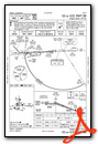
KPUB Airport Diagram

VFR Chart of KPUB
Sectional Charts at SkyVector.com
IFR Chart of KPUB
Enroute Charts at SkyVector.com
Location Information for KPUB
Coordinates: N38°17.40' / W104°29.88'Located 05 miles E of Pueblo, Colorado on 3872 acres of land. View all Airports in Colorado.
Surveyed Elevation is 4729 feet MSL.
Operations Data
|
|
Airport Communications
| ATIS: | 125.25 |
|---|---|
| ASOS: | Tel. 719-225-7029 |
| PUEBLO TOWER: | 119.1 257.8 |
| PUEBLO GROUND: | 121.9 |
| DENVER APPROACH: | 120.1 290.5 |
| DENVER DEPARTURE: | 120.1 290.5 |
| CLEARANCE DELIVERY: | 120.9 |
| UNICOM: | 122.950 |
| CTAF: | 119.100 |
| EMERG: | 121.5 243.0 |
| AWOS-3 at FCS (26.0 NW): | 125.0 719-637-9696 |
| ATIS at FCS (26.3 NW): | 226.3 |
| AWOS-3PT at 1V6 (29.7 W): | 120.025 (719) 784-2014 |
- DENVER APCH (D01) PRVDDS APCH/DEP CTL SVC FM 0600-2200; DENVER ARTCC (ZDV) PRVDDS APCH/DEP SVC FM 2200-0600 ON FREQS 128.375/379.95 (PUEBLO RCAG).
- SAID IN USE. OPERATE TRANSPONDERS WITH ALTITUDE REPORTING MODE AND ADS-B (IF EQUIPPED) ENABLED ON ALL AIRPORT SURFACES.
Nearby Navigation Aids
|
| ||||||||||||||||||||||||||||||||||||||||||||||||


Runway 08R/26L
| Dimensions: | 10498 x 150 feet / 3200 x 46 meters | |
|---|---|---|
| Surface: | Asphalt / Grooved in Good Condition | |
| Weight Limits: | S-75, D-170, ST-250
PCR VALUE: 517/F/D/X/T
| |
| Edge Lighting: | High Intensity | |
| Runway 08R | Runway 26L | |
| Coordinates: | N38°17.23' / W104°30.60' | N38°17.28' / W104°28.41' |
| Elevation: | 4669.4 | 4648.8 |
| Traffic Pattern: | Right | Left |
| Runway Heading: | 88° True | 268° True |
| Declared Distances: | TORA:10496 TODA:10496 ASDA:10496 LDA:10496 | TORA:10496 TODA:10496 ASDA:10496 LDA:10496 |
| Markings: | Precision Instrument in good condition. | Precision Instrument in good condition. |
| Glide Slope Indicator | P4L (3.00° Glide Path Angle) | P4L (3.00° Glide Path Angle) |
| Approach Lights: | MALSR 1,400 Foot Medium-intensity Approach Lighting System with runway alignment indicator lights. | |
| REIL: | Yes | |
Runway 17/35
| Dimensions: | 8310 x 150 feet / 2533 x 46 meters | |
|---|---|---|
| Surface: | Asphalt / Grooved in Good Condition | |
| Weight Limits: | S-93, D-110, ST-170
PCR VALUE: 610/F/B/X/T
| |
| Edge Lighting: | Medium Intensity | |
| Runway 17 | Runway 35 | |
| Coordinates: | N38°18.25' / W104°30.24' | N38°16.88' / W104°30.19' |
| Elevation: | 4729.3 | 4648.1 |
| Traffic Pattern: | Left | Left |
| Runway Heading: | 178° True | 358° True |
| Declared Distances: | TORA:8308 TODA:8308 ASDA:8308 LDA:8308 | TORA:8308 TODA:8308 ASDA:8308 LDA:8308 |
| Markings: | Non-Precision Instrument in good condition. | Non-Precision Instrument in good condition. |
| Glide Slope Indicator | P4L (3.00° Glide Path Angle) | P4L (3.00° Glide Path Angle) |
| REIL: | Yes | Yes |
Runway 08L/26R
AVBL TO ACFT UNDER 20000 LBS DURING DALGT AND NIGHT HRS. | ||
| Dimensions: | 4690 x 75 feet / 1430 x 23 meters | |
|---|---|---|
| Surface: | Asphalt / Grooved in Good Condition | |
| Weight Limits: | S-20 | |
| Edge Lighting: | Medium Intensity | |
| Runway 08L | Runway 26R | |
| Coordinates: | N38°17.41' / W104°30.61' | N38°17.43' / W104°29.63' |
| Elevation: | 4681.2 | 4677.0 |
| Traffic Pattern: | Left | Left |
| Runway Heading: | 88° True | 268° True |
| Declared Distances: | TORA:4690 TODA:4690 ASDA:4690 LDA:4690 | TORA:4690 TODA:4690 ASDA:4690 LDA:4690 |
| Markings: | Basic in good condition. | Basic in good condition. |
| Glide Slope Indicator | P4L (3.00° Glide Path Angle) | P4L (3.00° Glide Path Angle) |
| REIL: | Yes | Yes |
Services Available
| Fuel: | 100LL (blue), Jet-A |
|---|---|
| Transient Storage: | Hangars,Tiedowns |
| Airframe Repair: | MAJOR |
| Engine Repair: | MAJOR |
| Bottled Oxygen: | HIGH |
| Bulk Oxygen: | NOT AVAILABLE |
| Other Services: | CROP DUSTING SERVICES,AIR AMBULANCE SERVICES,CHARTER SERVICE,PILOT INSTRUCTION,AIRCRAFT RENTAL,AIRCRAFT SALES,ANNUAL SURVEYING |
Ownership Information
| Ownership: | Publicly owned | |
|---|---|---|
| Owner: | CITY OF PUEBLO | |
| 1 CITY HALL | ||
| PUEBLO, CO 81003 | ||
| (719) 553-2744 | ||
| Manager: | GREG PEDROZA | |
| 31201 BRYAN CIRCLE | ||
| PUEBLO, CO 81001 | ||
| 719-553-2760 | ||
Other Remarks
- SEE FLIP AP/1 SUPPLEMENTARY ARPT INFO.
- CONDS NOT MNT 2200L-0600L.
- TWY A BTN TWY D AND A6 50 FT WID.
- FOR CD CTC PUEBLO APCH AT 303-342-1916, WHEN APCH CLSD CTC DENVER ARTCC AT 303-651-4257.
- TXL E 30 FT WIDE BTN TWY E6 AND TWY E7.
- RPD RFL AVBL F/W, R/W DUR FBO HR 0700L-2200L. CTC FBO 719-948-1310 24 HR PN & FREQ 122.95 PRIOR TO LNDG. ADZ ATC FOR RPD RFL OPS & PROCD TO WEST RAMP.
- HIGH VOLUME TRNG DA-20 ACFT SR-SS MON-FRI. OVERHEAD PATTERN DURG TRNG. EXTENSIVE USE OF TRNG AREA 12-28 DME N-SW OF ARPT 500 FT AGL-8500 FT MSL.
- BE ALERT; INTENSIVE USAF STUDENT TRAINING IN VICINITY OF COLORADO SPRINGS & PUEBLO COLORADO.
- 0LL AFT HRS (719) 948-1310 OR USE 100LL SELF-SVC.
- WHEN ATCT CLSD ACTVT MALSR RWY 08R; REIL RWY 08L, 17, 26R, 26L & 35; PAPI RWY 08R, 08L, 17, 26R & 35; HIRL RWY 08R/26L; MIRL RWY 08L/26R, 17/35 - CTAF. PAPI RWY 26L ON CONSLY.
Weather Minimums
Instrument Approach Procedure (IAP) Charts


Departure Procedure (DP) Charts


Nearby Airports with Instrument Procedures
| ID | Name | Heading / Distance | ||
|---|---|---|---|---|
 |
1V6 | Fremont County Airport | 286° | 29.9 |
|
KCOS | City of Colorado Springs Municipal Airport | 342° | 32.4 |
|
4V1 | Spanish Peaks Airfield Airport | 201° | 38.1 |
|
KFLY | Meadow Lake Airport | 355° | 39.3 |
|
KLHX | La Junta Municipal Airport | 106° | 48.9 |
|
KTAD | Perry Stokes Airport | 173° | 62.2 |
|
KLIC | Limon Municipal Airport | 033° | 70.8 |
|
KANK | Salida/Harriett Alexander Field Airport | 281° | 74.6 |
|
KAPA | Centennial Airport | 348° | 78.5 |
|
KAEJ | Central Colorado Regional Airport | 292° | 82.6 |
|
KALS | San Luis Valley Regional/Bergman Field Airport | 232° | 82.8 |
|
KBKF | Buckley Space Force Base Airport | 352° | 85.5 |

 Airport from E")


Comments
Closed old runway 12/30
On charts and diagrams, the airfield is distinctive for its two primary perpendicular runway strips (8R/26L and 17/35) as well as the smaller 8L/26R. This may confuse airmen who, on arrival, see a more traingular formation with large diagonal bands running from near the end of 17 in a SE direction to about 2500' from the end of 26L. This diagonal is the remnants of former asphalt unway 12/30, which has been closed since at least the early 1990s, and its taxiway. It is extremely visible from the air but not shown on charts. Obviously it should not be used.
Pages