
Login
Register


TAD
Perry Stokes Airport
Official FAA Data Effective 2026-01-22 0901Z
Chart Supplement
VFR Chart of KTAD
Sectional Charts at SkyVector.com
IFR Chart of KTAD
Enroute Charts at SkyVector.com
Location Information for KTAD
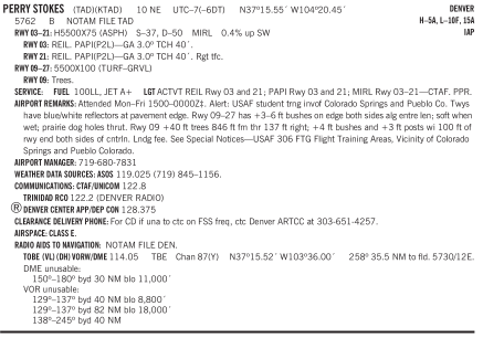
Coordinates: N37°15.55' / W104°20.45'Located 10 miles NE of Trinidad, Colorado on 650 acres of land. View all Airports in Colorado.
Surveyed Elevation is 5761 feet MSL.
Operations Data
|
|
Airport Communications
| ASOS: | 119.025 Tel. 719-845-1156 |
|---|---|
| CTAF: | 122.800 |
| UNICOM: | 122.800 |
| ASOS at RTN (32.0 S): | 118.375 575-303-2003 |
| AWOS-3PT at 4V1 (33.7 NW): | 123.6 719-738-1053 |
| AWOS-3 at VTP (42.4 W): | 119.925 719-587-3120 |
- APCH/DEP CTL SVC PRVDD BY DENVER ARTCC (ZDV) ON FREQS 128.375/379.95 (PUEBLO RCAG).
Nearby Navigation Aids
|
| ||||||||||||||||||||||||||||||||||||


Runway 03/21
| Dimensions: | 5500 x 75 feet / 1676 x 23 meters | |
|---|---|---|
| Surface: | Asphalt in Excellent Condition | |
| Weight Limits: | S-37, D-50 | |
| Edge Lighting: | Medium Intensity | |
| Runway 03 | Runway 21 | |
| Coordinates: | N37°15.26' / W104°20.65' | N37°15.90' / W104°19.85' |
| Elevation: | 5760.4 | 5740.3 |
| Traffic Pattern: | Left | Right |
| Runway Heading: | 45° True | 225° True |
| Markings: | Non-Precision Instrument in good condition. | Non-Precision Instrument in good condition. |
| Glide Slope Indicator | P2L (3.00° Glide Path Angle) | P2L (3.00° Glide Path Angle) |
| REIL: | Yes | Yes |
Runway 09/27
+3-6 FT BUSHES ON EDGE BOTH SIDES ALG ENTRE LEN; SOFT WHEN WET; PRAIRIE DOG HOLES THRUT. | ||
| Dimensions: | 5500 x 100 feet / 1676 x 30 meters | |
|---|---|---|
| Surface: | Turf-Gravel in Fair Condition | |
| Runway 09 | Runway 27 | |
| Coordinates: | N37°15.65' / W104°21.19' | N37°15.40' / W104°20.10' |
| Elevation: | 5759.3 | 5747.7 |
| Traffic Pattern: | Left | Left |
| Runway Heading: | 106° True | 286° True |
| Markings: | None in poor condition. | None in poor condition. |
| Obstacles: | 41 ft Trees 784 ft from runway, 151 ft left of center | |
Services Available
| Fuel: | 100LL (blue), Jet A+ |
|---|---|
| Transient Storage: | Hangars,Tiedowns |
| Airframe Repair: | NOT AVAILABLE |
| Engine Repair: | NOT AVAILABLE |
| Bottled Oxygen: | NOT AVAILABLE |
| Bulk Oxygen: | NOT AVAILABLE |
Ownership Information
| Ownership: | Publicly owned | |
|---|---|---|
| Owner: | LAS ANIMAS COUNTY | |
| PHIL DORENKAMP, 200 E 1ST ST | ||
| TRINIDAD, CO 81082-9607 | ||
| 719-845-2598 | ||
| Manager: | EVAN OTTO | |
| 44814 CO RD 38.0 | ||
| TRINIDAD, CO 81082-9607 | ||
| 719-680-7831 | ||
Other Remarks
- FOR CD IF UNA TO CTC ON FSS FREQ, CTC DENVER ARTCC AT 303-651-4257.
- TWYS HAVE BLUE/WHITE REFLECTORS AT PAVEMENT EDGE.
- ALERT: USAF STUDENT TRNG INVOF COLORADO SPRINGS & PUEBLO CO.
- +40 FT TREES 846 FT FM THR 137 FT RIGHT; +4 FT BUSHES & +3 FT POSTS WI 100 FT OF RWY END BOTH SIDES OF CNTRLN.
- ACTVT REIL RWY 03 & 21; PAPI RWY 03 & 21; MIRL RWY 03/21 - CTAF. PPR.
Weather Minimums

Instrument Approach Procedure (IAP) Charts
Departure Procedure Obstacles (DPO) Charts
Nearby Airports with Instrument Procedures
| ID | Name | Heading / Distance | ||
|---|---|---|---|---|
 |
KRTN | Raton Municipal/Crews Field Airport | 194° | 31.9 |
|
4V1 | Spanish Peaks Airfield Airport | 321° | 33.7 |
|
KLHX | La Junta Municipal Airport | 039° | 61.8 |
|
KPUB | Pueblo Memorial Airport | 353° | 62.2 |
|
KAXX | Angel Fire Airport | 222° | 67.9 |
|
KALS | San Luis Valley Regional/Bergman Field Airport | 278° | 73.8 |
|
KCAO | Clayton Municipal Airpark Airport | 129° | 75.2 |
|
1V6 | Fremont County Airport | 332° | 79.0 |
|
KSKX | Taos Regional Airport | 233° | 80.4 |
|
KMVI | Monte Vista Municipal Airport | 281° | 83.1 |
|
8V7 | Springfield Municipal Airport | 081° | 83.3 |
|
KLAA | Southeast Colorado Regional Airport | 057° | 92.5 |




Comments
Runway 03/21 is in good
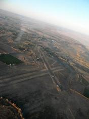
Runway 03/21 is in good condition. The brick terminal is a time warp. Once a host to commerical air service, the lobby holds a soda fountian (not working). In the 1950's the airport was an FAA weather station and the radios and weather instruments are still intact. The airport sits 12 miles east of Trinidad and does not offer a courtesy car. There is a taxi service available from Trinidad. The airport manager is friendly and helpful.
Pages