Login
Register


XNX
Music City Exec Airport
Official FAA Data Effective 2026-01-22 0901Z
Chart Supplement

VFR Chart of KXNX
Sectional Charts at SkyVector.com
IFR Chart of KXNX
Enroute Charts at SkyVector.com
Location Information for KXNX
Coordinates: N36°22.50' / W86°24.50'Located 02 miles E of Gallatin, Tennessee on 332 acres of land. View all Airports in Tennessee.
Surveyed Elevation is 583 feet MSL.
Operations Data
|
|
Airport Communications
| AWOS-3: | 132.725 Tel. 615-230-8005 |
|---|---|
| NASHVILLE APPROACH: | 118.4 360.7 |
| NASHVILLE DEPARTURE: | 118.4 360.7 |
| UNICOM: | 123.050 |
| CTAF: | 123.050 |
| AWOS-3 at M54 (11.8 S): | 118.325 615-444-5778 |
| AWOS-3PT at 1M5 (13.7 N): | 118.175 615-325-4971 |
| D-ATIS at BNA (19.9 SW): | 135.1 |
Nearby Navigation Aids
|
| ||||||||||||||||||||||||||||||||||||||||||||||||||||||||||||


Runway 17/35
| Dimensions: | 6300 x 100 feet / 1920 x 30 meters | |
|---|---|---|
| Surface: | Asphalt in Excellent Condition | |
| Weight Limits: | 27 /F/C/X/T, S-71, D-94 | |
| Edge Lighting: | Medium Intensity | |
| Runway 17 | Runway 35 | |
| Coordinates: | N36°23.02' / W86°24.60' | N36°21.99' / W86°24.41' |
| Elevation: | 583.3 | 532.5 |
| Traffic Pattern: | Left | Left |
| Runway Heading: | 171° True | 351° True |
| Markings: | Non-Precision Instrument in good condition. | Non-Precision Instrument in good condition. |
| Glide Slope Indicator | P2L (3.00° Glide Path Angle) UNUSBL BYD 5 DEGS RIGHT OF CNTRLN DUE TO OBST. | P2L (3.00° Glide Path Angle) |
| REIL: | Yes | Yes |
| Obstacles: | 99 ft Tree 2073 ft from runway, 472 ft right of center | |
Services Available
| Fuel: | 100LL (blue), Jet-A |
|---|---|
| Transient Storage: | Hangars,Tiedowns |
| Airframe Repair: | MAJOR |
| Engine Repair: | MAJOR |
| Bottled Oxygen: | LOW |
| Bulk Oxygen: | NOT AVAILABLE |
| Other Services: | CHARTER SERVICE,PILOT INSTRUCTION,AIRCRAFT RENTAL,AIRCRAFT SALES |
Ownership Information
| Ownership: | Publicly owned | |
|---|---|---|
| Owner: | MUSIC CITY EXECUTIVE AIRPORT AUTH | |
| 1475 AIRPORT ROAD | ||
| GALLATIN, TN 37066 | ||
| 615-452-7248 | ||
| Manager: | JEFF DUNHAM | |
| 1475 AIRPORT ROAD | ||
| GALLATIN, TN 37066 | ||
| (615) 452-7248 | ||
Other Remarks
- GCO AVBL ON FREQ 135.075 THRU NASHVILLE CD. IF UNA, FOR CD CTC NASHVILLE APCH AT 615-695-4522.
- ACTVT REIL RWY 17 & 35; PAPI RWY 17 & 35; MIRL RWY 17/35 - CTAF.
Weather Minimums


Instrument Approach Procedure (IAP) Charts
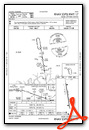
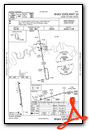
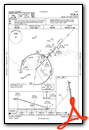
Nearby Airports with Instrument Procedures
| ID | Name | Heading / Distance | ||
|---|---|---|---|---|
 |
M54 | Lebanon Municipal Airport | 157° | 11.9 |
|
1M5 | Douglas Hunter Field Airport | 345° | 13.5 |
|
3M7 | Lafayette Municipal Airport | 062° | 19.1 |
|
KBNA | Nashville International Airport | 221° | 19.9 |
|
KMQY | Smyrna Airport | 193° | 22.6 |
|
KJWN | John C Tune Airport | 243° | 25.9 |
|
M91 | Springfield Robertson County Airport | 291° | 26.6 |
|
KMBT | Murfreesboro Municipal Airport | 177° | 29.8 |
|
4M7 | Russellville-Logan County Airport | 322° | 32.0 |
|
KBWG | Bowling Green-Warren County Regional Airport | 359° | 35.3 |
|
0A3 | Smithville Municipal Airport | 128° | 37.3 |
|
KTZV | Tompkinsville/Monroe County Airport | 059° | 42.3 |


