Login
Register


M54
Lebanon Municipal Airport
Official FAA Data Effective 2026-01-22 0901Z
Chart Supplement

VFR Chart of M54
Sectional Charts at SkyVector.com
IFR Chart of M54
Enroute Charts at SkyVector.com
Location Information for M54
Coordinates: N36°11.42' / W86°18.94'Located 02 miles SW of Lebanon, Tennessee on 256 acres of land. View all Airports in Tennessee.
Surveyed Elevation is 588 feet MSL.
Operations Data
|
|
Airport Communications
| AWOS-3: | 118.325 Tel. 615-444-5778 |
|---|---|
| NASHVILLE APPROACH: | 118.4 360.7 |
| NASHVILLE DEPARTURE: | 118.4 360.7 |
| CTAF: | 122.725 |
| UNICOM: | 122.725 |
| AWOS-3 at XNX (12.0 N): | 132.725 615-230-8005 |
| AWOS-3PT at MQY (14.8 SW): | 119.125 615-223-7716 |
| D-ATIS at BNA (18.0 W): | 135.1 |
Nearby Navigation Aids
|
| ||||||||||||||||||||||||||||||||||||||||||||||||||||||||||||


Runway 01/19
| Dimensions: | 5000 x 100 feet / 1524 x 30 meters | |
|---|---|---|
| Surface: | Asphalt in Good Condition | |
| Weight Limits: | 19 /F/C/X/T, S-51, D-71 | |
| Edge Lighting: | Medium Intensity | |
| Runway 01 | Runway 19 | |
| Coordinates: | N36°11.02' / W86°19.04' | N36°11.84' / W86°18.93' |
| Elevation: | 588.0 | 549.7 |
| Traffic Pattern: | Left | Left |
| Runway Heading: | 7° True | 187° True |
| Displaced Threshold: | 400 Feet | 500 Feet |
| Declared Distances: | TORA:5000 TODA:5000 ASDA:4680 LDA:4527 | TORA:5000 TODA:5000 ASDA:4847 LDA:4527 |
| Markings: | Non-Precision Instrument in good condition. | Non-Precision Instrument in good condition. |
| Glide Slope Indicator | P2L (3.00° Glide Path Angle) PAPI OTS INDEF. | P2L (3.00° Glide Path Angle) |
| REIL: | Yes | Yes |
| Obstacles: | 58 ft Trees 1268 ft from runway, 225 ft right of center | |
Runway 04/22
| Dimensions: | 1801 x 150 feet / 549 x 46 meters | |
|---|---|---|
| Surface: | Turf in Good Condition | |
| Runway 04 | Runway 22 | |
| Coordinates: | N36°11.31' / W86°18.95' | N36°11.52' / W86°18.68' |
| Elevation: | 568.0 | 565.0 |
| Traffic Pattern: | Left | Left |
| Runway Heading: | 46° True | 226° True |
| Markings: | Basic in good condition. | Basic in good condition. |
| Obstacles: | 113 ft Sign 2500 ft from runway, 297 ft right of center | 54 ft Trees 422 ft from runway, 184 ft right of center |
Services Available
| Fuel: | 100LL (blue), Jet-A |
|---|---|
| Transient Storage: | Hangars,Tiedowns |
| Airframe Repair: | MAJOR |
| Engine Repair: | MAJOR |
| Bottled Oxygen: | LOW SERVICE UP TO 1800 PSI |
| Bulk Oxygen: | NOT AVAILABLE |
| Other Services: | AIR FREIGHT SERVICES,AIR AMBULANCE SERVICES,AVIONICS,CARGO HANDLING SERVICES,PILOT INSTRUCTION,AIRCRAFT RENTAL |
Ownership Information
| Ownership: | Publicly owned | |
|---|---|---|
| Owner: | CITY OF LEBANON | |
| 200 CASTLE HEIGHTS AVE NORTH | ||
| LEBANON, TN 37087 | ||
| 615-443-2839 | ||
| Manager: | HEATHER BAY | |
| 200 AVIATION WAY, SUITE 116 | ||
| LEBANON, TN 37090 | ||
| 615-604-7436 | ||
Other Remarks
- WILDLIFE ON & INVOF ARPT.
- FOR CD CTC NASHVILLE APCH AT 615-695-4522.
- FLT TRNG WI ARPT AREA.
- CLSD EASTER, THANKSGIVING, CHRISTMAS & NEW YEARS DAY.
- CALM WIND RWY.
- THR & DTHR MKD 3 FT WHITE CONES.
- THR & DTHR MKD 3 FT WHITE CONES.
Weather Minimums

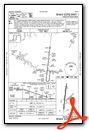
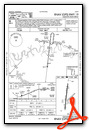
Instrument Approach Procedure (IAP) Charts
Nearby Airports with Instrument Procedures
| ID | Name | Heading / Distance | ||
|---|---|---|---|---|
 |
KXNX | Music City Exec Airport | 337° | 11.9 |
|
KMQY | Smyrna Airport | 222° | 14.7 |
|
KBNA | Nashville International Airport | 257° | 18.1 |
|
KMBT | Murfreesboro Municipal Airport | 189° | 18.9 |
|
3M7 | Lafayette Municipal Airport | 032° | 23.4 |
|
1M5 | Douglas Hunter Field Airport | 342° | 25.3 |
|
0A3 | Smithville Municipal Airport | 116° | 27.5 |
|
KJWN | John C Tune Airport | 269° | 27.7 |
|
M91 | Springfield Robertson County Airport | 305° | 35.9 |
|
KRNC | Warren County Memorial Airport | 141° | 37.4 |
|
KSYI | Bomar Field/Shelbyville Municipal Airport | 189° | 38.3 |
|
KSRB | Upper Cumberland Regional Airport | 101° | 39.0 |
Fuel Providers

Airport Images
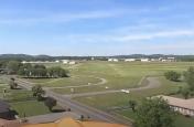
By: Big Orange Bird
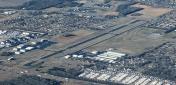
By: axisofentropy@g...
- 1 of 2
- next ›


