Login
Register


MCX
White County Airport
Official FAA Data Effective 2026-01-22 0901Z
Chart Supplement

VFR Chart of KMCX
Sectional Charts at SkyVector.com
IFR Chart of KMCX
Enroute Charts at SkyVector.com
Location Information for KMCX
Coordinates: N40°42.61' / W86°46.01'Located 03 miles S of Monticello, Indiana on 51 acres of land. View all Airports in Indiana.
Surveyed Elevation is 678 feet MSL.
Operations Data
|
|
Airport Communications
| AWOS-3P: | 124.05 Tel. 574-583-0531 |
|---|---|
| GRISSOM APPROACH: | 123.85 291.675 |
| GRISSOM DEPARTURE: | 123.85 291.675 |
| UNICOM: | 122.800 |
| CTAF: | 122.800 |
| AWOS-3P at GGP (17.9 E): | 118.5 574-737-7310 |
| ASOS at LAF (19.5 SW): | 765-743-9687 |
| ATIS at LAF (19.5 SW): | 127.75 |
- APCH/DEP SVC PRVDD BY CHICAGO ARTCC ON FREQ 123.85 (LAFAYETTE RCAG) WHEN GRISSOM (GUS) APCH/DEP CON CLSD.
Nearby Navigation Aids
|
| ||||||||||||||||||||||||||||||||||||||||||||||||||||||||||||


Runway 18/36
| Dimensions: | 5001 x 75 feet / 1524 x 23 meters | |
|---|---|---|
| Surface: | Asphalt / Grooved in Excellent Condition | |
| Weight Limits: | 9 /F/C/Y/T, S-25, D-40 | |
| Edge Lighting: | Medium Intensity | |
| Runway 18 | Runway 36 | |
| Coordinates: | N40°43.02' / W86°46.02' | N40°42.20' / W86°46.00' |
| Elevation: | 678.5 | 669.4 |
| Traffic Pattern: | Left | Left |
| Runway Heading: | 179° True | 359° True |
| Markings: | Non-Precision Instrument in good condition. | Non-Precision Instrument in good condition. |
| Glide Slope Indicator | P2L (3.00° Glide Path Angle) UNUSBL BYD 8 DEGS RIGHT OF CNTRLN. | P2L (4.00° Glide Path Angle) |
| REIL: | Yes | Yes |
| Obstacles: | 11 ft Fence 400 ft from runway, 145 ft left of center | |
Services Available
| Fuel: | 100LL (blue), Jet-A |
|---|---|
| Transient Storage: | Hangars,Tiedowns |
| Airframe Repair: | MINOR |
| Engine Repair: | MINOR |
| Bottled Oxygen: | NONE |
| Bulk Oxygen: | NONE |
| Other Services: | CROP DUSTING SERVICES |
Ownership Information
| Ownership: | Publicly owned | |
|---|---|---|
| Owner: | WHITE COUNTY BOAC | |
| 2222 AIRPORT RD | ||
| MONTICELLO, IN 47960 | ||
| 574-583-9900 | ||
| Manager: | DEREK SHANNON | |
| 2222 AIRPORT RD | ||
| MONTICELLO, IN 47960 | ||
| 574-583-9900 | ||
Other Remarks
- TWY EDGE MARKED WITH 2 FT YELLOW CYLINDER REFLECTORS.
- DEER INVOF ARPT.
- FREQUENT AERIAL APPLICATION TFC DUR MONTHS OF JUN, JUL, AUG.
- FOR CD CTC CHICAGO ARTCC AT 630-906-8921.
- 0LL SELF SVC AVBL 24 HRS.
- UNDERWING & OVERWING REFUELING AVAILABLE UPON REQUEST. SELF SVC AVBL 24 HRS.
- ACTVT REIL RWY 18/36; MIRL 18/36 - CTAF.
Weather Minimums


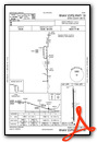
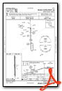
Instrument Approach Procedure (IAP) Charts
Nearby Airports with Instrument Procedures
| ID | Name | Heading / Distance | ||
|---|---|---|---|---|
 |
1I9 | Delphi Municipal Airport | 158° | 10.9 |
|
KGGP | Logansport/Cass County Airport | 089° | 18.0 |
|
KLAF | Purdue University Airport | 203° | 19.5 |
|
KRZL | Jasper County Airport | 307° | 23.7 |
|
KRWN | Arens Field Airport | 016° | 24.0 |
|
KFKR | Frankfort Clinton County Regional Airport | 160° | 27.8 |
|
KGUS | Grissom Arb Airport | 097° | 28.3 |
|
I76 | Peru Municipal Airport | 080° | 28.7 |
|
50I | Kentland Municipal Airport | 275° | 30.3 |
|
KOKK | Kokomo Municipal Airport | 108° | 34.1 |
|
KRCR | Fulton County Airport | 051° | 34.1 |
|
KOXI | Starke County Airport | 007° | 37.4 |
Airport Images
 airport (KMCX) & Tippecanoe River, from 3nm SW")
By: 2flaps

By: 2flaps


