Login
Register


MDZ
Taylor County Airport
Official FAA Data Effective 2026-01-22 0901Z
Chart Supplement

VFR Chart of KMDZ
Sectional Charts at SkyVector.com
IFR Chart of KMDZ
Enroute Charts at SkyVector.com
Location Information for KMDZ
Coordinates: N45°6.08' / W90°18.01'Located 03 miles SE of Medford, Wisconsin on 567 acres of land. View all Airports in Wisconsin.
Surveyed Elevation is 1478 feet MSL.
Operations Data
|
|
Airport Communications
| AWOS-3: | 119.025 Tel. 715-678-6030 |
|---|---|
| UNICOM: | 122.800 |
| CTAF: | 122.800 |
| AWOS-3 at RRL (25.7 E): | 119.925 715-539-8422 |
| ASOS at MFI (28.2 S): | 121.575 715-384-3046 |
| AWOS-3 at TKV (30.4 NE): | 118.250 715-453-5716 |
- APCH/DEP SVC PRVDD BY MINNEAPOLIS ARTCC ON FREQS 124.4/317.7 (MOSINEE RCAG).
Nearby Navigation Aids
|
| ||||||||||||||||||||||||||||||||||||||||||||||||


Runway 09/27
| Dimensions: | 6000 x 100 feet / 1829 x 30 meters | |
|---|---|---|
| Surface: | Asphalt in Good Condition | |
| Edge Lighting: | Medium Intensity | |
| Runway 09 | Runway 27 | |
| Coordinates: | N45°6.19' / W90°18.40' | N45°6.20' / W90°17.01' |
| Elevation: | 1463.0 | 1478.1 |
| Runway Heading: | 89° True | 269° True |
| Markings: | Non-Precision Instrument in good condition. | Non-Precision Instrument in good condition. |
| Glide Slope Indicator | P4L (3.00° Glide Path Angle) | P4L (3.00° Glide Path Angle) |
| REIL: | Yes | Yes |
Runway 16/34
| Dimensions: | 4435 x 75 feet / 1352 x 23 meters | |
|---|---|---|
| Surface: | Asphalt in Good Condition | |
| Weight Limits: | S-12 | |
| Edge Lighting: | Medium Intensity | |
| Runway 16 | Runway 34 | |
| Coordinates: | N45°6.25' / W90°18.64' | N45°5.59' / W90°18.21' |
| Elevation: | 1459.0 | 1451.2 |
| Traffic Pattern: | Left | Left |
| Runway Heading: | 156° True | 336° True |
| Markings: | Non-Precision Instrument in good condition. | Non-Precision Instrument in good condition. |
| Glide Slope Indicator | P2L (3.00° Glide Path Angle) | P2L (3.00° Glide Path Angle) |
| REIL: | Yes | |
Services Available
| Fuel: | 100LL (blue), Jet A+ |
|---|---|
| Transient Storage: | Hangars,Tiedowns |
| Airframe Repair: | NONE |
| Engine Repair: | NONE |
| Bottled Oxygen: | NONE |
| Bulk Oxygen: | NONE |
Ownership Information
| Ownership: | Publicly owned | |
|---|---|---|
| Owner: | TAYLOR COUNTY | |
| TAYLOR COUNTY COURTHOUSE | ||
| MEDFORD, WI 54451 | ||
| 715-748-1460 | ||
| Manager: | PATRICK COLWELL | |
| W5125 APPLE AVE | EMAIL ADDRESS: AIRPORT@CO.TAYLOR.WI.US | |
| MEDFORD, WI 54451 | ||
| 715-678-2152 | ||
Other Remarks
- FOR TAKE OFF ON RY 34 LEFT TURN AFTER 1000 FT 'AGL.
- SEASONAL BIRDS ON & INVOF ARPT.
- FOR CD CTC MINNEAPOLIS ARTCC AT 651-463-5588.
- 0LL SELF SVC FUEL AVBL H24 VIA CREDIT CARD.
- ACTVT REIL RWY 09, 27 & 34; PAPI RWY 09, 27, 16 & 34; MIRL RWY 16/34 - CTAF. MIRL RWY 09/27 PRESET TO LOW SS-SR; TO INCR INTST & ACTVT - CTAF.
Weather Minimums


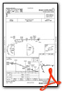
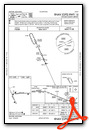
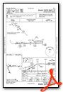
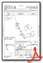
Instrument Approach Procedure (IAP) Charts
Nearby Airports with Instrument Procedures
| ID | Name | Heading / Distance | ||
|---|---|---|---|---|
 |
KRRL | Merrill Municipal Airport | 076° | 25.6 |
|
KMFI | Marshfield Municipal Airport | 170° | 28.3 |
|
KTKV | Tomahawk Regional Airport | 043° | 30.5 |
|
KAUW | Wausau Downtown Airport | 109° | 30.5 |
|
KCWA | Central Wisconsin Airport | 125° | 33.3 |
|
KVIQ | Neillsville Municipal Airport | 195° | 33.8 |
|
KPBH | Price County Airport | 353° | 36.7 |
|
KRCX | Rusk County Airport | 308° | 38.0 |
|
KSTE | Stevens Point Municipal Airport | 135° | 46.8 |
|
KRHI | Rhinelander/Oneida County Airport | 047° | 47.5 |
|
KISW | Alexander Field South Wood County Airport | 155° | 48.6 |
|
KAIG | Langlade County Airport | 086° | 50.6 |
Airport Images
Do you have a recent image of this airport? Upload it here!


