Login
Register


RRL
Merrill Municipal Airport
Official FAA Data Effective 2026-01-22 0901Z
Chart Supplement

VFR Chart of KRRL
Sectional Charts at SkyVector.com
IFR Chart of KRRL
Enroute Charts at SkyVector.com
Location Information for KRRL
Coordinates: N45°11.94' / W89°42.77'Located 01 miles NW of Merrill, Wisconsin on 439 acres of land. View all Airports in Wisconsin.
Surveyed Elevation is 1318 feet MSL.
Operations Data
|
|
Airport Communications
| AWOS-3: | 119.925 Tel. 715-539-8422 |
|---|---|
| CTAF: | 122.800 |
| UNICOM: | 122.800 |
| AWOS-3 at TKV (16.7 N): | 118.250 715-453-5716 |
| ASOS at AUW (16.8 S): | 125.925 715-843-7215 |
| ATIS at CWA (25.4 S): | 127.45 |
- APCH/DEP SVC PRVDD BY MINNEAPOLIS ARTCC ON FREQS 124.4/317.7 (MOSINEE RCAG).
Nearby Navigation Aids
|
| ||||||||||||||||||||||||||||||||||||||||||||||||||||||


Runway 07/25
| Dimensions: | 5101 x 75 feet / 1555 x 23 meters | |
|---|---|---|
| Surface: | Asphalt in Good Condition | |
| Weight Limits: | S-45, D-65, ST-100 | |
| Edge Lighting: | Medium Intensity | |
| Runway 07 | Runway 25 | |
| Coordinates: | N45°11.74' / W89°43.51' | N45°12.05' / W89°42.41' |
| Elevation: | 1318.1 | 1306.2 |
| Runway Heading: | 69° True | 249° True |
| Markings: | Non-Precision Instrument in good condition. | Non-Precision Instrument in good condition. |
| Glide Slope Indicator | P2L (3.00° Glide Path Angle) | P2L (3.00° Glide Path Angle) |
| REIL: | Yes | Yes |
| Obstacles: | 55 ft Trees 1600 ft from runway, 230 ft right of center | 35 ft Trees 1025 ft from runway, 85 ft right of center |
Runway 16/34
| Dimensions: | 2997 x 75 feet / 913 x 23 meters | |
|---|---|---|
| Surface: | Asphalt in Fair Condition | |
| Weight Limits: | S-26 | |
| Edge Lighting: | Medium Intensity | |
| Runway 16 | Runway 34 | |
| Coordinates: | N45°12.22' / W89°42.59' | N45°11.77' / W89°42.31' |
| Elevation: | 1317.7 | 1303.4 |
| Traffic Pattern: | Left | Left |
| Runway Heading: | 156° True | 336° True |
| Markings: | Basic in fair condition. | Basic in fair condition. |
| Obstacles: | 83 ft Trees 1775 ft from runway, 150 ft left of center | |
Services Available
| Fuel: | 100LL (blue), Jet A+ |
|---|---|
| Transient Storage: | Hangars,Tiedowns |
| Airframe Repair: | MAJOR |
| Engine Repair: | MINOR |
| Bottled Oxygen: | NONE |
| Bulk Oxygen: | NONE |
| Other Services: | PILOT INSTRUCTION,AIRCRAFT RENTAL |
Ownership Information
| Ownership: | Publicly owned | |
|---|---|---|
| Owner: | CITY OF MERRILL | |
| N2241 AIRPORT RD | ||
| MERRILL, WI 54452 | ||
| 715-536-2024 | ||
| Manager: | RICH MCCULLOUGH | |
| N2241 AIRPORT RD | ||
| MERRILL, WI 54452 | ||
| 715-536-2024 | ||
Other Remarks
- ULTRALIGHT ACT ON & INVOF ARPT.
- FOR CD CTC MINNEAPOLIS ARTCC AT 651-463-5588.
- 0LL FUEL AVBL H24 VIA CREDIT CARD.
- MIRL RWY 07/25 PRESET TO LOW SS-SR; TO INCR INTST & ACTVT REIL RWY 07 & 25; PAPI RWY 07 & 25; MIRL RWY 16/34; - CTAF.
Weather Minimums


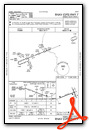
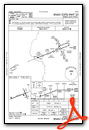
Instrument Approach Procedure (IAP) Charts
Nearby Airports with Instrument Procedures
| ID | Name | Heading / Distance | ||
|---|---|---|---|---|
 |
KTKV | Tomahawk Regional Airport | 346° | 16.7 |
|
KAUW | Wausau Downtown Airport | 167° | 16.8 |
|
KCWA | Central Wisconsin Airport | 175° | 25.3 |
|
KMDZ | Taylor County Airport | 256° | 25.6 |
|
KAIG | Langlade County Airport | 095° | 25.7 |
|
KRHI | Rhinelander/Oneida County Airport | 021° | 27.9 |
|
Y55 | Crandon/Steve Conway Municipal Airport | 059° | 38.5 |
|
KMFI | Marshfield Municipal Airport | 211° | 39.4 |
|
KSTE | Stevens Point Municipal Airport | 168° | 40.0 |
|
KPBH | Price County Airport | 316° | 42.2 |
|
KARV | Lakeland/Noble F Lee Memorial Field Airport | 359° | 43.8 |
|
KEGV | Eagle River Union Airport | 022° | 47.8 |
Airport Images
Do you have a recent image of this airport? Upload it here!


