Login
Register


CWA
Central Wisconsin Airport
Official FAA Data Effective 2026-01-22 0901Z
Chart Supplement

KCWA Airport Diagram

VFR Chart of KCWA
Sectional Charts at SkyVector.com
IFR Chart of KCWA
Enroute Charts at SkyVector.com
Location Information for KCWA
Coordinates: N44°46.67' / W89°39.95'Located 03 miles SE of Mosinee, Wisconsin on 1852 acres of land. View all Airports in Wisconsin.
Surveyed Elevation is 1277 feet MSL.
Operations Data
|
|
Airport Communications
| ATIS: | 127.45 |
|---|---|
| AWOS-3: | 127.45 Tel. 715-693-1116 |
| CWA TOWER: | 119.75 360.7 |
| CWA GROUND: | 121.9 360.7 |
| UNICOM: | 122.950 |
| CTAF: | 119.750 |
| ASOS at AUW (9.1 N): | 125.925 715-843-7215 |
| AWOS-3 at STE (15.1 S): | 119.275 715-344-5960 |
| ASOS at MFI (23.8 W): | 121.575 715-384-3046 |
- APCH/DEP SVC PRVDD BY MINNEAPOLIS ARTCC ON FREQS 124.4/317.7 (MOSINEE RCAG).
Nearby Navigation Aids
|
| ||||||||||||||||||||||||||||||||||||||||||||||||||||||||||||


Runway 08/26
| Dimensions: | 7723 x 150 feet / 2354 x 46 meters | |
|---|---|---|
| Surface: | Concrete / Grooved in Good Condition | |
| Weight Limits: | S-120, D-227, ST-409
PCR VALUE: 780/R/D/W/T
| |
| Edge Lighting: | High Intensity | |
| Runway 08 | Runway 26 | |
| Coordinates: | N44°46.81' / W89°40.45' | N44°47.08' / W89°38.71' |
| Elevation: | 1274.0 | 1260.2 |
| Traffic Pattern: | Left | Left |
| Runway Heading: | 77° True | 257° True |
| Declared Distances: | TORA:7629 TODA:7629 ASDA:7629 LDA:7723 | TORA:7723 TODA:7723 ASDA:7723 LDA:7629 |
| Markings: | Precision Instrument in good condition. | Non-Precision Instrument in fair condition. |
| Glide Slope Indicator | P4R (3.00° Glide Path Angle) | P4L (3.00° Glide Path Angle) PAPI UNUSBL BYD 6 DEGS R OF CNTRLN. |
| Approach Lights: | MALSR 1,400 Foot Medium-intensity Approach Lighting System with runway alignment indicator lights. | |
| REIL: | Yes | |
| Obstacles: | 18 ft Building 960 ft from runway, 400 ft left of center | |
Runway 17/35
| Dimensions: | 6501 x 150 feet / 1982 x 46 meters | |
|---|---|---|
| Surface: | Concrete / Grooved in Excellent Condition | |
| Weight Limits: | S-120, D-225, ST-485, DT-980
PCR VALUE: 910/R/D/W/T
| |
| Edge Lighting: | High Intensity | |
| Runway 17 | Runway 35 | |
| Coordinates: | N44°46.86' / W89°40.53' | N44°45.81' / W89°40.27' |
| Elevation: | 1277.2 | 1225.2 |
| Traffic Pattern: | Left | Left |
| Runway Heading: | 170° True | 350° True |
| Declared Distances: | TORA:6501 TODA:6501 ASDA:6501 LDA:6501 | TORA:6501 TODA:6501 ASDA:6501 LDA:6501 |
| Markings: | Non-Precision Instrument in good condition. | Precision Instrument in good condition. |
| Glide Slope Indicator | P4L (3.00° Glide Path Angle) | P4L (3.00° Glide Path Angle) |
| Approach Lights: | MALSR 1,400 Foot Medium-intensity Approach Lighting System with runway alignment indicator lights. | |
| REIL: | Yes | |
| Obstacles: | 82 ft Stack 2720 ft from runway, 840 ft left of center | |
Services Available
| Fuel: | 100LL (blue), Jet-A |
|---|---|
| Transient Storage: | Hangars,Tiedowns |
| Airframe Repair: | MAJOR |
| Engine Repair: | MAJOR |
| Bottled Oxygen: | NONE |
| Bulk Oxygen: | HIGH |
| Other Services: | AIR FREIGHT SERVICES,AIR AMBULANCE SERVICES,AVIONICS,CARGO HANDLING SERVICES,CHARTER SERVICE,PILOT INSTRUCTION,AIRCRAFT RENTAL |
Ownership Information
| Ownership: | Publicly owned | |
|---|---|---|
| Owner: | MARATHON AND PORTAGE CO | |
| 100 CWA DR. SUITE 227 | ||
| MOSINEE, WI 54455 | ||
| 715-693-2147 | ||
| Manager: | BRIAN GREFE | |
| 100 CWA DR. SUITE 227 | ||
| MOSINEE, WI 54455 | ||
| 715-693-2147 | EXT 7. | |
Other Remarks
- TWY E NORTH OF TWY A NOT AVBL FOR ACR OPS; GA & CARGO ACFT RSTRD TO LESS THAN 100000 LBS.
- LANDING FEE FOR ACFT PROVIDING COMMERICAL SVCS.
- WHEN ATCT CLSD, HIRL RWY 8/26 PRESET LOW; TO INCR INTST AND ACTVT MALSR RWY 8 & 35; REIL RWY 17 & 26; HIRL RWY 8/26 & 17/35 - CTAF. RWY 8, 17, 26 & 35 PAPI OPRS CONSLY.
Weather Minimums


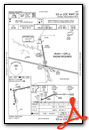
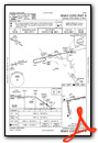
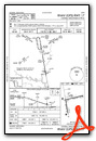
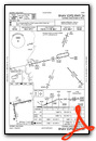
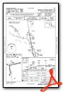
Instrument Approach Procedure (IAP) Charts

Nearby Airports with Instrument Procedures
| ID | Name | Heading / Distance | ||
|---|---|---|---|---|
 |
KAUW | Wausau Downtown Airport | 010° | 9.1 |
|
KSTE | Stevens Point Municipal Airport | 157° | 15.1 |
|
KMFI | Marshfield Municipal Airport | 249° | 23.9 |
|
KRRL | Merrill Municipal Airport | 355° | 25.3 |
|
KISW | Alexander Field South Wood County Airport | 196° | 26.1 |
|
KAIG | Langlade County Airport | 046° | 32.7 |
|
KMDZ | Taylor County Airport | 305° | 33.3 |
|
KPCZ | Waupaca Municipal Airport | 133° | 38.5 |
|
KVIQ | Neillsville Municipal Airport | 250° | 38.6 |
|
KCLI | Clintonville Municipal Airport | 103° | 41.2 |
|
KTKV | Tomahawk Regional Airport | 351° | 41.9 |
|
Y50 | Wautoma Municipal Airport | 160° | 46.7 |
Airport Images
Do you have a recent image of this airport? Upload it here!


