Login
Register


MKY
Marco Island Exec Airport
Official FAA Data Effective 2024-12-26 0901Z
Chart Supplement

VFR Chart of KMKY
Sectional Charts at SkyVector.com
IFR Chart of KMKY
Enroute Charts at SkyVector.com
Location Information for KMKY
Coordinates: N25°59.70' / W81°40.35'Located 04 miles NE of Marco Island, Florida on 140 acres of land. View all Airports in Florida.
Surveyed Elevation is 5 feet MSL.
Operations Data
|
|
Airport Communications
| AWOS-3PT: | 120.075 Tel. 239-394-8187 |
|---|---|
| FORT MYERS APPROACH: | 124.125 371.85 |
| FORT MYERS DEPARTURE: | 124.125 371.85 |
| CLEARANCE DELIVERY: | 120.8 |
| SHFTY STAR: | 126.8 |
| ZEILR STAR: | 134.425 306.2 |
| CTAF: | 122.700 |
| PIKKR STAR: | 127.05 ;5000 FT & BLO 134.425 ;6000 FT & ABV 306.2 |
| UNICOM: | 122.700 |
| ATIS at APF (11.0 NW): | 134.225 |
| ASOS at APF (11.1 NW): | 134.225 239-643-9886 |
| AWOS-3 at IMM (29.9 NE): | 118.525 239-657-2038 |
- APCH/DEP SVC PRVDD BY MIAMI ARTCC ON FREQS 134.75/322.5 (FORT MYERS RCAG) WHEN FORT MYERS APCH CTL CLSD.
Nearby Navigation Aids
|
| ||||||||||||||||||||||||||||||||||||||||||||||||


Runway 17/35
| Dimensions: | 5000 x 100 feet / 1524 x 30 meters | |
|---|---|---|
| Surface: | Asphalt / Grooved in Good Condition | |
| Weight Limits: | 26 /F/A/W/T, S-75, D-108 | |
| Edge Lighting: | Medium Intensity | |
| Runway 17 | Runway 35 | |
| Coordinates: | N26°0.11' / W81°40.45' | N25°59.30' / W81°40.25' |
| Elevation: | 5.0 | 5.1 |
| Traffic Pattern: | Left | Right |
| Runway Heading: | 168° True | 348° True |
| Markings: | Non-Precision Instrument in fair condition. | Non-Precision Instrument in fair condition. |
| Glide Slope Indicator | P4L (3.00° Glide Path Angle) | P4L (3.00° Glide Path Angle) |
| REIL: | Yes | Yes |
| Obstacles: | 7 ft Brush 345 ft from runway RWY 17 APCH RATIO 34:1 TO RWY END. |
7 ft Brush 365 ft from runway RY 35 APCH RATIO 34:1 TO RY END. |
Services Available
| Fuel: | 100LL (blue), Jet-A, Jet A+ |
|---|---|
| Transient Storage: | Tiedowns |
| Airframe Repair: | MINOR |
| Engine Repair: | MINOR |
| Bottled Oxygen: | NONE |
| Bulk Oxygen: | NONE |
| Other Services: | CHARTER SERVICE,PILOT INSTRUCTION,AIRCRAFT RENTAL |
Ownership Information
| Ownership: | Publicly owned | |
|---|---|---|
| Owner: | COLLIER COUNTY AIRPORT AUTHORITY | |
| 2005 MAINSAIL DRIVE | ||
| NAPLES, FL 34114 | ||
| 239-252-8400 | ||
| Manager: | BRYANT GARRETT | |
| 2005 MAINSAIL DRIVE, SUITE 1 | ||
| NAPLES, FL 34114 | ||
| 239-252-8425 | ||
Other Remarks
- FOR CD CTC FORT MYERS APCH AT239-416-1026, WHEN APCH CLSD CTC MIAMI ARTCC AT 305-716-1731.
- RWY 35 DSGND CALM WIND RWY FOR ARRS 2200-0700. RWY 17 DSGND CALM WIND RWY FOR DEPS 2200-0700.
- FM NOV 1ST TO APR 30TH - 24 HR PPR REQ FOR ACFT OVNGT PRKG.
- ARPT VSBY UNRELIABLE.
- NOISE SENSITIVE AREA. USE NBAA CLOSE IN NOISE ABATEMMENT PROCEDURES.
- BANNER TOWING ON AND INVOF ARPT.
- FOR FUEL AND SVC AFTER HRS CALL 239-394-3355.
- NUMEROUS BIRDS & WILDLIFE ON AND INVOF ARPT.
- 0LL SELF SVC AVGAS 100LL AVBL 24 HRS BY CREDIT CARD.
- ACTVT REIL RWY 17 & 35; PAPI RWY 17 & 35; MIRL RWY 17/35 - CTAF.
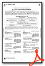
Weather Minimums
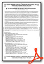
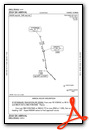
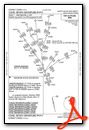
Standard Terminal Arrival (STAR) Charts
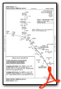
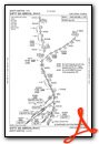
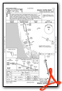
Instrument Approach Procedure (IAP) Charts
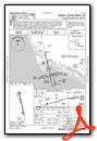
Departure Procedure (DP) Charts
Nearby Airports with Instrument Procedures
| ID | Name | Heading / Distance | ||
|---|---|---|---|---|
 |
KAPF | Naples Municipal Airport | 329° | 10.9 |
|
KIMM | Immokalee Regional Airport | 029° | 30.1 |
|
KRSW | Southwest Florida International Airport | 352° | 32.7 |
|
KFMY | Page Field Airport | 343° | 36.9 |
|
KTNT | Dade-Collier Training and Transition Airport | 100° | 42.7 |
|
X14 | La Belle Municipal Airport | 016° | 46.5 |
|
2IS | Airglades Airport | 036° | 55.5 |
|
KPGD | Punta Gorda Airport | 342° | 57.9 |
|
FA54 | Coral Creek Airport | 328° | 60.1 |
|
X51 | Miami Homestead General Aviation Airport | 115° | 67.5 |
|
KTMB | Miami Exec Airport | 106° | 70.2 |
|
KPHK | Palm Beach County Glades Airport | 047° | 70.8 |
Airport Images

By: vincent10717


