Login
Register


FYG
Washington Regional Airport
Official FAA Data Effective 2026-02-19 0901Z
Chart Supplement

VFR Chart of KFYG
Sectional Charts at SkyVector.com
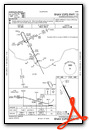
IFR Chart of KFYG
Enroute Charts at SkyVector.com
Location Information for KFYG
Coordinates: N38°35.25' / W90°59.63'Located 03 miles N of Washington, Missouri on 507 acres of land. View all Airports in Missouri.
Surveyed Elevation is 487 feet MSL.
Operations Data
|
|
Airport Communications
| AWOS-3PT: | 121.325 Tel. 636-433-5914 |
|---|---|
| SAINT LOUIS APPROACH: | 126.5 254.3 |
| SAINT LOUIS DEPARTURE: | 126.5 254.3 |
| CTAF: | 122.800 |
| UNICOM: | 122.800 |
| ASOS at SUS (16.4 E): | 134.8 314-890-7255 |
| ATIS at SUS (16.6 E): | 134.8 |
| AWOS-3PT at UUV (22.7 S): | 119.375 573-860-2596 |
Nearby Navigation Aids
|
| ||||||||||||||||||||||||||||||||||||||||||||||||||||||||||||


Runway 15/33
| Dimensions: | 5002 x 75 feet / 1525 x 23 meters | |
|---|---|---|
| Surface: | Concrete in Good Condition | |
| Weight Limits: | S-30 | |
| Edge Lighting: | Medium Intensity | |
| Runway 15 | Runway 33 | |
| Coordinates: | N38°35.63' / W90°59.86' | N38°34.88' / W90°59.40' |
| Elevation: | 487.7 | 485.1 |
| Traffic Pattern: | Right | |
| Runway Heading: | 154° True | 334° True |
| Markings: | Non-Precision Instrument in good condition. | Non-Precision Instrument in good condition. |
| Glide Slope Indicator | P4L (3.00° Glide Path Angle) | P4L (3.00° Glide Path Angle) |
| REIL: | Yes | Yes |
Services Available
| Fuel: | 100LL (blue), Jet A+ |
|---|---|
| Transient Storage: | Tiedowns |
| Airframe Repair: | MAJOR |
| Engine Repair: | MAJOR |
| Bottled Oxygen: | NOT AVAILABLE |
| Bulk Oxygen: | NOT AVAILABLE |
| Other Services: | PILOT INSTRUCTION |
Ownership Information
| Ownership: | Publicly owned | |
|---|---|---|
| Owner: | CITY OF WASHINGTON | |
| 405 JEFFERSON STREET | ||
| WASHINGTON, MO 63090 | ||
| 636-433-5454 | ||
| Manager: | KEVIN HELLMANN | |
| 405 JEFFERSON ST. | ||
| WASHINGTON, MO 63090 | ||
| 636-283-4220 | ||
Other Remarks
- LARGE WATERFOWL AND WILDLIFE ON AND INVOF ARPT
- FOR CD CTC ST LOUIS APCH AT 314-890-1017.
- MIRL RWY 15/33 PRESET ON MED INTST DUSK TO 0000; TO INCR INTST & ACTVT REIL RWYS 15 & 33 AND MIRL RWY 15/33 - CTAF. PAPI RWYS 15 & 33 OPR CONSLY.
Weather Minimums


Instrument Approach Procedure (IAP) Charts


Nearby Airports with Instrument Procedures
| ID | Name | Heading / Distance | ||
|---|---|---|---|---|
 |
KSUS | Spirit of St Louis Airport | 074° | 16.7 |
|
KUUV | Sullivan Regional Airport | 200° | 22.7 |
|
1H0 | Creve Coeur Airport | 069° | 24.3 |
|
KSTL | St Louis Lambert International Airport | 071° | 30.9 |
|
KSET | St Charles County Regional/Smartt Field Airport | 052° | 33.5 |
|
KUBX | Cuba Municipal Airport | 213° | 37.3 |
|
KCPS | St Louis Downtown Airport | 091° | 39.5 |
|
8WC | Washington County Airport | 162° | 41.4 |
|
KVIH | Rolla Ntl Airport | 233° | 45.8 |
|
KALN | St Louis Regional Airport | 067° | 48.0 |
|
H19 | Bowling Green Municipal Airport | 347° | 48.1 |
|
KFTT | Elton Hensley Memorial Airport | 287° | 49.7 |
Airport Images
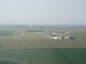
By: bcool


