Login
Register


MVN
Mount Vernon Airport
Official FAA Data Effective 2026-02-19 0901Z
Chart Supplement

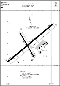
KMVN Airport Diagram
VFR Chart of KMVN
Sectional Charts at SkyVector.com
IFR Chart of KMVN
Enroute Charts at SkyVector.com
Location Information for KMVN
Coordinates: N38°19.40' / W88°51.51'Located 03 miles E of Mount Vernon, Illinois on 1100 acres of land. View all Airports in Illinois.
Surveyed Elevation is 480 feet MSL.
Operations Data
|
|
Airport Communications
| AWOS-3PT: | 118.2 Tel. 618-242-7933 |
|---|---|
| CTAF: | 123.000 |
| UNICOM: | 123.000 |
| AWOS-3PT at ENL (15.9 NW): | 121.125 618-533-4417 |
| AWOS-3PT at SLO (19.8 N): | 118.525 618-312-1051 |
| AWOS-3PT at FWC (21.2 E): | 119.425 618-847-4709 |
- APCH/DEP SVC PRVDD BY KANSAS CITY ARTCC ON FREQS 127.7/351.825 (MOUNT VERNON RCAG).
Nearby Navigation Aids
|
| ||||||||||||||||||||||||||||||||||||||||||||||||||||||||||||


Runway 05/23
RWY 05/23 NOT AVBL FOR PART 121/PART 380 OPS WITH SKED PAX CARRYING OPS MORE THAN 9 PAX SEATS AND NON-SKED PAX CARRYING OPS MORE THAN 30 PAX SEATS. 90 DAY PPR FOR UNSKED ACR OPS GTR THAN 30 PAX SEATS - CALL AMGR. 618-242-7016 | ||
| Dimensions: | 6496 x 150 feet / 1980 x 46 meters | |
|---|---|---|
| Surface: | Asphalt / Grooved in Good Condition | |
| Weight Limits: | S-120, D-177, ST-238, DT-678
PCR VALUE: 550/F/D/X/T
| |
| Edge Lighting: | High Intensity | |
| Runway 05 | Runway 23 | |
| Coordinates: | N38°19.07' / W88°52.01' | N38°19.76' / W88°50.96' |
| Elevation: | 466.8 | 467.8 |
| Traffic Pattern: | Left | Left |
| Runway Heading: | 50° True | 230° True |
| Displaced Threshold: | 774 Feet | |
| Declared Distances: | TORA:6496 TODA:6496 ASDA:6496 LDA:5722 | TORA:5572 TODA:5572 ASDA:5572 LDA:5572 |
| Markings: | Precision Instrument in good condition. | Precision Instrument in good condition. |
| Glide Slope Indicator | V4L (3.00° Glide Path Angle) | |
| Approach Lights: | MALSR 1,400 Foot Medium-intensity Approach Lighting System with runway alignment indicator lights. RY 23 MALSR AVBL DALGT HRS. | |
| Obstacles: | 12 ft Road 200 ft from runway, 395 ft right of center ALSO 18 FT RR 238 FT FM RY END 498 FT R OF CNTRLN 2:1 SLOPE. APCH RATIO TO DSPLCD THLD 34:1 OVR TREES 2583 FT FM DSPLCD THLD 158 FT R OF CNTRLN. 12 FT ROAD 0-200 FT FM THLD 395 FT R TO 495 FT R OF CNTRLN. |
97 ft Trees 2988 ft from runway, 54 ft left of center |
Runway 15/33
RWY 15/33 NOT AVBL FOR PART 121/PART 380 OPS WITH SKED PAX CARRYING OPS MORE THAN 9 PAX SEATS AND NON-SKED PAX CARRYING OPS MORE THAN 30 PAX SEATS. 90 DAY PPR FOR UNSKED ACR OPS GTR THAN 30 PAX SEATS - CALL AMGR. 618-242-7016 | ||
| Dimensions: | 3146 x 100 feet / 959 x 30 meters | |
|---|---|---|
| Surface: | Asphalt / Porous Friction Course in Fair Condition | |
| Weight Limits: | S-55, D-72, ST-121
PCR VALUE: 220/F/D/X/T
| |
| Edge Lighting: | Medium Intensity | |
| Runway 15 | Runway 33 | |
| Coordinates: | N38°19.60' / W88°51.73' | N38°19.15' / W88°51.40' |
| Elevation: | 480.4 | 457.0 |
| Traffic Pattern: | Left | Left |
| Runway Heading: | 150° True | 330° True |
| Declared Distances: | TORA:3146 TODA:3146 ASDA:3146 LDA:3146 | TORA:3146 TODA:3146 ASDA:3146 LDA:3146 |
| Markings: | Basic in fair condition. | Basic in fair condition. |
| Obstacles: | 63 ft Tree 873 ft from runway, 180 ft left of center | 23 ft Railroad 613 ft from runway, 166 ft left of center |
Helipad H1
FOR PVT USE BY AIR-EVAC LIFETEAM ONLY. | ||
| Dimensions: | 80 x 40 feet / 24 x 12 meters | |
|---|---|---|
| Surface: | Concrete | |
| Edge Lighting: | Perimeter | |
| Coordinates: | N38°19.17' / W88°51.12' | N0°0.00' / E0°0.00' |
| Elevation: | 457.0 | |
Services Available
| Fuel: | 100LL (blue), Jet-A |
|---|---|
| Transient Storage: | Hangars,Tiedowns |
| Airframe Repair: | MAJOR |
| Engine Repair: | MAJOR |
| Bottled Oxygen: | NOT AVAILABLE |
| Bulk Oxygen: | LOW |
| Other Services: | CARGO HANDLING SERVICES,CHARTER SERVICE,PILOT INSTRUCTION,AIRCRAFT RENTAL,AIRCRAFT SALES |
Ownership Information
| Ownership: | Publicly owned | |
|---|---|---|
| Owner: | MT VERNON ARPT AUTHORITY | |
| 100 AVIATION DRIVE | ||
| MT VERNON, IL 62864 | ||
| 618-242-7016 | ||
| Manager: | CHRIS COLLINS | |
| 100 AVIATION DRIVE | ||
| MT VERNON, IL 62864 | ||
| 618-242-7016 | ||
Other Remarks
- MIGRATORY WATERFOWL INVOF ARPT.
- FOR CD CTC KANSAS CITY ARTCC AT 913-254-8508.
- ACTVT MALSR RY 23 - CTAF. ACTVT MIRL RY 15/33 & HIRL RY 05/23 - CTAF NIGHT ONLY.
Weather Minimums


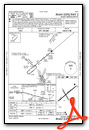
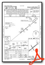
Instrument Approach Procedure (IAP) Charts

Nearby Airports with Instrument Procedures
| ID | Name | Heading / Distance | ||
|---|---|---|---|---|
 |
KENL | Centralia Municipal Airport | 316° | 15.9 |
|
H96 | Benton Municipal Airport | 190° | 19.2 |
|
KSLO | Salem-Leckrone Airport | 345° | 19.8 |
|
KFWC | Fairfield Municipal Airport | 080° | 21.3 |
|
KFOA | Flora Municipal Airport | 042° | 28.0 |
|
KPJY | Pinckneyville/Du Quoin Airport | 229° | 31.5 |
|
KHSB | Harrisburg-Raleigh Airport | 154° | 34.0 |
|
KMWA | Veterans Airport of Southern Illinois Airport | 192° | 34.8 |
|
KCUL | Carmi Municipal Airport | 111° | 37.5 |
|
KMDH | Southern Illinois Airport | 209° | 37.6 |
|
KGRE | Greenville Airport | 321° | 39.3 |
|
KOLY | Olney-Noble Airport | 053° | 40.0 |
Fuel Providers

Airport Images
Do you have a recent image of this airport? Upload it here!


