Login
Register


OK37
Dog Iron Ranch Airport
Official FAA Data Effective 2026-02-19 0901Z
VFR Chart of OK37
Sectional Charts at SkyVector.com
IFR Chart of OK37
Enroute Charts at SkyVector.com
Location Information for OK37
Coordinates: N36°28.17' / W95°40.07'Located 03 miles NE of Oologah, Oklahoma. View all Airports in Oklahoma.
Estimated Elevation is 760 feet MSL.
Operations Data
|
|
Airport Communications
| AWOS-3PT at GCM (14.0 SE): | 119.925 918-343-0184 |
|---|---|
| ASOS at TUL (19.2 SW): | 539-399-0187 |
| D-ATIS at TUL (19.5 SW): | 124.9 |
Nearby Navigation Aids
|
| ||||||||||||||||||||||||||||||||||||||||||||||||||||||||||||


Runway 17/35
| Dimensions: | 2000 x 25 feet / 610 x 8 meters | |
|---|---|---|
| Surface: | Turf | |
| Runway 17 | Runway 35 | |
Ownership Information
| Ownership: | Privately Owned | |
|---|---|---|
| Owner: | WILL ROGERS MEMORIAL & BIRTHPLACE | |
| PO BOX 157 | ||
| CLAREMORE, OK 74018 | ||
| 918-341-0719 | ||
| Manager: | TAD JONES | |
| PO BOX 157 | ||
| CLAREMORE, OK 74018 | ||
| 918-341-0719 | ||
Other Remarks
- FOR CD CTC TULSA APCH AT 918-831-6714/6720.
Nearby Airports with Instrument Procedures
| ID | Name | Heading / Distance | ||
|---|---|---|---|---|
 |
KGCM | Claremore Regional Airport | 139° | 14.0 |
|
KTUL | Tulsa International Airport | 213° | 19.4 |
|
H71 | Mid-America Industrial Airport | 131° | 22.0 |
|
KBVO | Bartlesville Municipal Airport | 316° | 24.2 |
|
H04 | Vinita Municipal Airport | 070° | 26.4 |
|
KOWP | William R Pogue Municipal Airport | 233° | 29.4 |
|
KRVS | Tulsa Riverside Airport | 210° | 30.0 |
|
1K8 | South Grand Lake Regional Airport | 081° | 32.0 |
|
H68 | Hefner-Easley Airport | 152° | 34.1 |
|
KCFV | Coffeyville Municipal Airport | 007° | 37.7 |
|
KIDP | Independence Municipal Airport | 352° | 41.6 |
|
KGMJ | Grove Regional Airport | 079° | 45.7 |
Airport Images
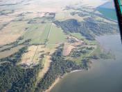
By: Rod


