Login
Register


VES
Darke County Airport
Official FAA Data Effective 2026-02-19 0901Z
Chart Supplement

VFR Chart of KVES
Sectional Charts at SkyVector.com
IFR Chart of KVES
Enroute Charts at SkyVector.com
Location Information for KVES
Coordinates: N40°12.26' / W84°31.95'Located 02 miles SW of Versailles, Ohio on 115 acres of land. View all Airports in Ohio.
Surveyed Elevation is 1007 feet MSL.
Operations Data
|
|
Airport Communications
| AWOS-3PT: | 125.9 Tel. 937-526-3154 |
|---|---|
| COLUMBUS APPROACH: | 134.45 352.05 |
| COLUMBUS DEPARTURE: | 134.45 352.05 |
| IC: | 352.05 |
| CTAF: | 122.800 |
| UNICOM: | 122.800 |
| AWOS-3 at SCA (17.5 E): | 120.425 937-492-3683 |
| AWOS-3PT at AXV (20.7 NE): | 128.325 419-753-2821 |
| ASOS at DAY (22.7 SE): | 937-419-1421 |
Nearby Navigation Aids
|
| ||||||||||||||||||||||||||||||||||||||||||||||||||||||||||||


Runway 09/27
| Dimensions: | 4802 x 75 feet / 1464 x 23 meters | |
|---|---|---|
| Surface: | Asphalt in Good Condition | |
| Weight Limits: | S-12 | |
| Edge Lighting: | Medium Intensity | |
| Runway 09 | Runway 27 | |
| Coordinates: | N40°12.25' / W84°32.46' | N40°12.27' / W84°31.43' |
| Elevation: | 1004.8 | 1004.0 |
| Traffic Pattern: | Left | Left |
| Runway Heading: | 89° True | 269° True |
| Markings: | Non-Precision Instrument in good condition. | Non-Precision Instrument in good condition. |
| Glide Slope Indicator | P2L (3.00° Glide Path Angle) | P2L (3.00° Glide Path Angle) |
| REIL: | Yes | Yes |
Services Available
| Fuel: | 100LL (blue), Jet A+ |
|---|---|
| Transient Storage: | Hangars,Tiedowns PRIOR CDN RQRD. |
| Airframe Repair: | NONE |
| Engine Repair: | NONE |
| Bottled Oxygen: | NONE |
| Bulk Oxygen: | NONE |
| Other Services: | AIR AMBULANCE SERVICES |
Ownership Information
| Ownership: | Publicly owned | |
|---|---|---|
| Owner: | DARKE CO COMMISSIONERS | |
| DARKE CO COURTHOUSE | ||
| GREENVILLE, OH 45331-1993 | ||
| 937-547-7370 | ||
| Manager: | SCOTT NAAS | SNAAS@CO.DARKE.OH.US. |
| 9724 STATE ROUTE 121 | ||
| VERSAILLES, OH 45380-9513 | ||
| 937-467-9360 | ||
Other Remarks
- OCNL DEER, BIRDS, & OTR WILDLIFE ON & INVOF ARPT.
- FOR CD CTC COLUMBUS APCH AT 614-338-8537.
- 0LL FUEL LCTD AT EAST RAMP AVBL H24 VIA CREDIT CARD.
- ACTVT REIL RWY 09 & 27; MIRL RWY 09/27 - CTAF. PAPI RWY 09 & 27 OPR CONSLY.
Weather Minimums

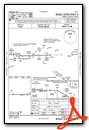
Instrument Approach Procedure (IAP) Charts

Nearby Airports with Instrument Procedures
| ID | Name | Heading / Distance | ||
|---|---|---|---|---|
 |
I17 | Piqua/Hartzell Field Airport | 102° | 10.6 |
|
KCQA | Lakefield Airport | 355° | 16.8 |
|
KSCA | Sidney Municipal Airport | 082° | 17.8 |
|
I22 | Randolph County Airport | 263° | 18.4 |
|
3I7 | Dayton/Phillipsburg Airport | 160° | 18.5 |
|
KAXV | Neil Armstrong Airport | 031° | 20.4 |
|
KDAY | James M Cox Dayton International Airport | 141° | 23.2 |
|
KPLD | Portland Municipal Airport | 305° | 25.8 |
|
KRID | Richmond Municipal Airport | 208° | 30.5 |
|
KFFO | Wright-Patterson AFB Airport | 135° | 31.9 |
|
I73 | Moraine Air Park Airport | 156° | 34.1 |
|
KEDJ | Bellefontaine Regional Airport | 072° | 34.3 |
Airport Images
By: snaas@co.darke.oh.us


