Login
Register


HHG
Huntington Municipal Airport
Official FAA Data Effective 2025-12-25 0901Z
Chart Supplement

VFR Chart of KHHG
Sectional Charts at SkyVector.com
IFR Chart of KHHG
Enroute Charts at SkyVector.com
Location Information for KHHG
Coordinates: N40°51.18' / W85°27.42'Located 03 miles SE of Huntington, Indiana on 133 acres of land. View all Airports in Indiana.
Surveyed Elevation is 805 feet MSL.
Operations Data
|
|
Airport Communications
| AWOS-3PT: | 126.575 Tel. 260-454-1927 |
|---|---|
| FORT WAYNE APPROACH: | 127.2 284.6 |
| FORT WAYNE DEPARTURE: | 127.2 284.6 |
| CTAF: | 122.800 |
| UNICOM: | 122.800 |
| ATIS at FWA (14.1 NE): | 121.25 |
| ASOS at FWA (14.1 NE): | 121.25 260-209-0224 |
| AWOS-3 at SMD (22.2 NE): | 124.55 260-490-4030 |
Nearby Navigation Aids
|
| ||||||||||||||||||||||||||||||||||||||||||||||||||||||||||||


Runway 10/28
| Dimensions: | 5003 x 75 feet / 1525 x 23 meters | |
|---|---|---|
| Surface: | Asphalt / Grooved in Good Condition | |
| Weight Limits: | S-38, D-50 | |
| Edge Lighting: | Medium Intensity | |
| Runway 10 | Runway 28 | |
| Coordinates: | N40°51.19' / W85°27.97' | N40°51.16' / W85°26.88' |
| Elevation: | 804.8 | 804.2 |
| Traffic Pattern: | Left | Left |
| Runway Heading: | 92° True | 272° True |
| Markings: | Non-Precision Instrument in good condition. | Non-Precision Instrument in good condition. |
| Glide Slope Indicator | P2L (3.00° Glide Path Angle) | P2L (3.00° Glide Path Angle) |
| REIL: | Yes | Yes |
| Obstacles: | 33 ft Trees 300 ft from runway, 240 ft right of center | 55 ft Trees 1100 ft from runway |
Services Available
| Fuel: | 100LL (blue), Jet-A |
|---|---|
| Transient Storage: | Hangars,Tiedowns |
| Airframe Repair: | MAJOR |
| Engine Repair: | MAJOR |
| Bottled Oxygen: | NONE |
| Bulk Oxygen: | NONE |
| Other Services: | PILOT INSTRUCTION,AIRCRAFT RENTAL,AIRCRAFT SALES |
Ownership Information
| Ownership: | Publicly owned | |
|---|---|---|
| Owner: | HUNTINGTON BOAC | |
| 1365 WARREN RD | ||
| HUNTINGTON, IN 46750 | ||
| 260-356-8515 | ||
| Manager: | SCOTT NICOLA | |
| 1365 WARREN RD | ||
| HUNTINGTON, IN 46750 | ||
| 260-356-8515 | ||
Other Remarks
- THIS AIRPORT HAS BEEN SURVEYED BY THE NATIONAL GEODETIC SURVEY.
- DEER ON & INVOF ARPT SPCLY MORNING & EVE.
- FOR CD CTC CHICAGO ARTCC AT 630-906-8921.
- 0LL SELF SVC AVBL.
- ACTVT REIL RWY 10 & 28; MIRL RWY 1028 - CTAF. MIRL RWY 10/28 PRESET LOW INTST; INCR INTST - CTAF.
Weather Minimums
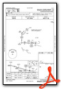
Instrument Approach Procedure (IAP) Charts


Nearby Airports with Instrument Procedures
| ID | Name | Heading / Distance | ||
|---|---|---|---|---|
 |
KFWA | Fort Wayne International Airport | 057° | 14.1 |
|
KIWH | Wabash Municipal Airport | 250° | 16.5 |
|
KSMD | Smith Field Airport | 038° | 22.2 |
|
KMZZ | Marion Municipal - Mckinney Field Airport | 205° | 24.0 |
|
KASW | Warsaw Municipal Airport | 325° | 30.7 |
|
I76 | Peru Municipal Airport | 262° | 31.7 |
|
KPLD | Portland Municipal Airport | 138° | 32.1 |
|
KGWB | Auburn/Dekalb Exec Airport | 033° | 32.6 |
|
KOKK | Kokomo Municipal Airport | 234° | 33.7 |
|
KGUS | Grissom Arb Airport | 249° | 34.0 |
|
KRCR | Fulton County Airport | 291° | 35.3 |
|
KMIE | Delaware County Regional Airport | 175° | 36.7 |
Airport Images
Do you have a recent image of this airport? Upload it here!


