Login
Register


CQA
Lakefield Airport
Official FAA Data Effective 2026-01-22 0901Z
Chart Supplement

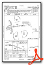
VFR Chart of KCQA
Sectional Charts at SkyVector.com
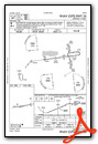
IFR Chart of KCQA
Enroute Charts at SkyVector.com
Location Information for KCQA
Coordinates: N40°29.06' / W84°33.49'Located 04 miles S of Celina, Ohio on 122 acres of land. View all Airports in Ohio.
Surveyed Elevation is 894 feet MSL.
Operations Data
|
|
Airport Communications
| COLUMBUS APPROACH: | 134.45 352.05 |
|---|---|
| COLUMBUS DEPARTURE: | 134.45 352.05 |
| IC: | 352.05 |
| CTAF: | 122.800 |
| UNICOM: | 122.800 |
| AWOS-3PT at AXV (12.1 E): | 128.325 419-753-2821 |
| AWOS-3PT at VES (16.8 S): | 125.9 937-526-3154 |
| AWOS-3 at PLD (19.9 W): | 124.675 260-726-7882 |
Nearby Navigation Aids
|
| ||||||||||||||||||||||||||||||||||||||||||||||||||||||||||||


Runway 08/26
| Dimensions: | 4400 x 75 feet / 1341 x 23 meters | |
|---|---|---|
| Surface: | Asphalt in Good Condition | |
| Weight Limits: | S-30 | |
| Edge Lighting: | Medium Intensity | |
| Runway 08 | Runway 26 | |
| Coordinates: | N40°29.01' / W84°33.96' | N40°29.10' / W84°33.02' |
| Elevation: | 894.2 | 886.5 |
| Traffic Pattern: | Left | Left |
| Runway Heading: | 83° True | 263° True |
| Markings: | Non-Precision Instrument in fair condition. | Non-Precision Instrument in fair condition. |
| Glide Slope Indicator | P4L (3.00° Glide Path Angle) | P4L (3.00° Glide Path Angle) |
| REIL: | Yes | Yes |
Services Available
| Fuel: | 100LL (blue), Jet-A |
|---|---|
| Transient Storage: | Hangars,Tiedowns |
| Airframe Repair: | NONE |
| Engine Repair: | NONE |
| Bottled Oxygen: | NONE |
| Bulk Oxygen: | NONE |
Ownership Information
| Ownership: | Publicly owned | |
|---|---|---|
| Owner: | LAKEFIELD ARPT AUTH | |
| MERCER CO COMMISSIONERS OFC, 220 W LIVINGSTON ST STE A201 | ||
| CELINA, OH 45822-1673 | ||
| 419-586-3178 | ||
| Manager: | JONATHAN JEFFERIES | LAKEFIELD.CQA@GMAIL.COM. |
| 6177 STATE ROUTE 219 | ||
| CELINA, OH 45822-9512 | ||
| 419-586-2190 | OR 419-268-2190. | |
Other Remarks
- FOR CD CTC COLUMBUS APCH AT 614-338-8537.
- BIRDS & WILDLIFE ON & INVOF ARPT.
- 0LL 100LL & JET A AVBL H24 SELF SVC VIA CREDIT CARD.
- ACTVT REIL RWY 08 & 26; MIRL RWY 08/26 - 123.3.
Weather Minimums

Instrument Approach Procedure (IAP) Charts
Nearby Airports with Instrument Procedures
| ID | Name | Heading / Distance | ||
|---|---|---|---|---|
 |
KAXV | Neil Armstrong Airport | 087° | 11.9 |
|
KVES | Darke County Airport | 175° | 16.8 |
|
KPLD | Portland Municipal Airport | 264° | 19.9 |
|
I17 | Piqua/Hartzell Field Airport | 149° | 22.3 |
|
KVNW | Van Wert County Airport | 354° | 22.9 |
|
KSCA | Sidney Municipal Airport | 127° | 23.8 |
|
I22 | Randolph County Airport | 222° | 25.5 |
|
KAOH | Lima Allen County Airport | 060° | 27.7 |
|
KEDJ | Bellefontaine Regional Airport | 100° | 34.5 |
|
3I7 | Dayton/Phillipsburg Airport | 167° | 35.0 |
|
KDAY | James M Cox Dayton International Airport | 155° | 38.2 |
|
5G7 | Bluffton Airport | 052° | 39.6 |
Airport Images
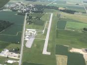
By: btracy62


