Login
Register


FWA
Fort Wayne International Airport
Official FAA Data Effective 2026-01-22 0901Z
Chart Supplement

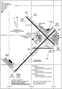
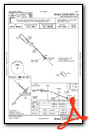
KFWA Airport Diagram
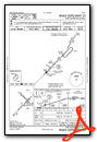
VFR Chart of KFWA
Sectional Charts at SkyVector.com
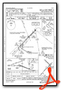
IFR Chart of KFWA
Enroute Charts at SkyVector.com
Location Information for KFWA
Coordinates: N40°58.71' / W85°11.71'Located 07 miles SW of Fort Wayne, Indiana on 3351 acres of land. View all Airports in Indiana.
Surveyed Elevation is 814 feet MSL.
Operations Data
|
|
Airport Communications
| ATIS: | 121.25 360.825 |
|---|---|
| ASOS: | 121.25 Tel. 260-209-0224 |
| FORT WAYNE TOWER: | 119.1 269.325 |
| FORT WAYNE GROUND: | 121.9 348.6 |
| FORT WAYNE APPROACH: | 127.2 ;SW/NW OF ACTIVE RWY 132.15 ;SE/NE OF ACTIVE RWY 135.325 282.325 ;SE/NE OF ACTIVE RWY 284.6 ;SW/NW OF ACTIVE RWY |
| FORT WAYNE DEPARTURE: | 127.2 ;SW/NW OF ACTIVE RWY 132.15 ;SE/NE OF ACTIVE RWY 135.325 282.325 ;SE/NE OF ACTIVE RWY 284.6 ;SW/NW OF ACTIVE RWY |
| IC: | 127.2 ;SW/NW OF ACTIVE RWY 284.6 ;SW/NW OF ACTIVE RWY |
| CLEARANCE DELIVERY: | 124.75 |
| UNICOM: | 122.950 |
| SFA: | 369.2 398.2 |
| EMERG: | 121.5 243.0 |
| CLASS C: | 127.2 ;SW/NW OF ACTIVE RWY 132.15 ;SE/NE OF ACTIVE RWY 282.325 ;SE/NE OF ACTIVE RWY 284.6 ;SW/NW OF ACTIVE RWY |
| COMD POST: | 138.625 |
| AWOS-3 at SMD (10.1 N): | 124.55 260-490-4030 |
| AWOS-3PT at HHG (14.1 SW): | 126.575 260-454-1927 |
| AWOS-3P at GWB (20.7 N): | 124.15 260-925-8225 |
Nearby Navigation Aids
|
| ||||||||||||||||||||||||||||||||||||||||||||||||||||||||||||


Runway 05/23
| Dimensions: | 11981 x 150 feet / 3652 x 46 meters | |
|---|---|---|
| Surface: | Asphalt-Concrete / Grooved in Good Condition | |
| Weight Limits: | S-120, D-203, ST-357, DT-847
PCR VALUE: 820/R/B/W/T
| |
| Edge Lighting: | High Intensity | |
| Runway 05 | Runway 23 | |
| Coordinates: | N40°57.76' / W85°12.76' | N40°59.17' / W85°10.94' |
| Elevation: | 814.5 | 798.5 |
| Traffic Pattern: | Left | Left |
| Runway Heading: | 44° True | 224° True |
| Declared Distances: | TORA:11981 TODA:11981 ASDA:11981 LDA:11981 | TORA:11981 TODA:11981 ASDA:11981 LDA:11981 |
| Markings: | Precision Instrument in good condition. | Non-Precision Instrument in good condition. |
| Glide Slope Indicator | P4L (3.00° Glide Path Angle) | |
| RVR Equipment | Touchdown Midfield Rollout | Touchdown Midfield Rollout |
| Approach Lights: | ALSF2 Standard 2,400 Foot High-intensity Approach Lighting System with sequenced flashers, CATEGORY II or III Configuration. | |
| REIL: | Yes | |
| Centerline Lights: | Yes | Yes |
| Obstacles: | 23 ft Railroad 800 ft from runway, 585 ft left of center | |
Runway 14/32
| Dimensions: | 8002 x 150 feet / 2439 x 46 meters | |
|---|---|---|
| Surface: | Asphalt-Concrete / Grooved in Good Condition | |
| Weight Limits: | S-120, D-189, ST-326, DT-799
PCR VALUE: 1089/R/B/W/T
| |
| Edge Lighting: | High Intensity | |
| Runway 14 | Runway 32 | |
| Coordinates: | N40°59.61' / W85°12.22' | N40°58.68' / W85°10.98' |
| Elevation: | 801.6 | 796.4 |
| Traffic Pattern: | Left | Left |
| Runway Heading: | 135° True | 315° True |
| Declared Distances: | TORA:8001 TODA:8001 ASDA:8001 LDA:8001 | TORA:8001 TODA:8001 ASDA:8001 LDA:8001 |
| Markings: | Non-Precision Instrument in good condition. | Precision Instrument in good condition. |
| Glide Slope Indicator | P4L (3.00° Glide Path Angle) | P4L (3.00° Glide Path Angle) |
| RVR Equipment | Rollout | Touchdown |
| Approach Lights: | MALSR 1,400 Foot Medium-intensity Approach Lighting System with runway alignment indicator lights. | |
| REIL: | Yes | |
| Obstacles: | 100 ft Tree 3672 ft from runway, 809 ft right of center | 26 ft Railroad 1084 ft from runway, 625 ft right of center |
Runway 09/27
RWY 09/27 NOT AVBL FOR PART 121/PART 380 OPS WITH SKED PAX CARRYING OPS MORE THAN 9 PAX SEATS AND NON-SKED PAX CARRYING OPS MORE THAN 30 PAX SEATS. NO PART 121/PART 380 OPS EXC FOR TAX. | ||
| Dimensions: | 4001 x 75 feet / 1220 x 23 meters | |
|---|---|---|
| Surface: | Asphalt-Concrete in Fair Condition | |
| Weight Limits: | S-100, D-190, ST-215, DT-430
PCR VALUE: 779/R/B/W/T
| |
| Runway 09 | Runway 27 | |
| Coordinates: | N40°58.55' / W85°11.93' | N40°58.55' / W85°11.06' |
| Elevation: | 798.4 | 793.4 |
| Runway Heading: | 90° True | 270° True |
| Declared Distances: | TORA:4001 TODA:4001 ASDA:4001 LDA:4001 | TORA:4001 TODA:4001 ASDA:4001 LDA:4001 |
| Markings: | Basic in good condition. | Basic in good condition. |
Services Available
| Fuel: | 100LL (blue), Jet-A, Jet A+ |
|---|---|
| Transient Storage: | Hangars,Tiedowns |
| Airframe Repair: | MAJOR |
| Engine Repair: | MAJOR |
| Bottled Oxygen: | HIGH |
| Bulk Oxygen: | NOT AVAILABLE |
| Other Services: | AIR FREIGHT SERVICES,AIR AMBULANCE SERVICES,AVIONICS,CARGO HANDLING SERVICES,CHARTER SERVICE,PILOT INSTRUCTION,AIRCRAFT RENTAL,AIRCRAFT SALES |
Ownership Information
| Ownership: | Publicly owned | |
|---|---|---|
| Owner: | FT WAYNE/ALLEN CO ARPT AUTH | |
| 3801 WEST FERGUSON ROAD, SUITE 209 | ||
| FORT WAYNE, IN 46809 | ||
| 260-747-4146 | ||
| Manager: | SCOTT D. HINDERMAN | |
| 3801 WEST FERGUSON ROAD, SUITE 209 | ||
| FORT WAYNE, IN 46809 | ||
| 260-747-4146 | ||
Other Remarks
- BIRDS ON & INVOF ARPT.
- ANG: PRK RAMP NSTD MRK INCL SOLID WHITE WINGTIP CLNC LINES BOTH SIDES OF TXL LCTD BTN E & W PRK ROWS, E & W OF BLDG 800 & MULT WHITE BOXES FOR ACFT GRD EQPT & MUNITIONS STORAGE AREA.
- ANG: UNUSE PAVEMENT FOR TAX LCTD CNTR OF APN WEST OF RSTD AREA - OPS FOR INFO.
- A-GEAR FOR LCL 122FW ONLY, PPR DSN 778-3202/3203 C800-842-3104 EXTN 202/203.
- TWY M & EAST RAMP MIL USE ONLY; OTR BY REQUEST - ANG 260-478-3202.
- TWY B ARM/DEARM AREA RSTRD TO MIL ACFT.
- TWY B/B, 1/B, 2/E & K CLSD TO WINGSPAN 79 FT OR GTR & WITH DUAL WHEEL TYPE LNDG GEAR IN EXCESS OF 50000 LB.
- 0LL NC-100LL, A - CALLOUT FEE 0400-1000Z++.
- ATC-CTL
- HOOK BAK-12B(B) (1650 FT).
- BAK-12(B) (1332 FT).
Weather Minimums


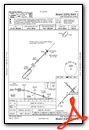
Instrument Approach Procedure (IAP) Charts


Nearby Airports with Instrument Procedures
| ID | Name | Heading / Distance | ||
|---|---|---|---|---|
 |
KSMD | Smith Field Airport | 010° | 10.1 |
|
KHHG | Huntington Municipal Airport | 237° | 14.1 |
|
KGWB | Auburn/Dekalb Exec Airport | 017° | 20.6 |
|
KVNW | Van Wert County Airport | 104° | 27.6 |
|
C62 | Kendallville Municipal Airport | 354° | 29.8 |
|
KIWH | Wabash Municipal Airport | 244° | 30.4 |
|
KPLD | Portland Municipal Airport | 163° | 32.9 |
|
KASW | Warsaw Municipal Airport | 301° | 34.2 |
|
KMZZ | Marion Municipal - Mckinney Field Airport | 217° | 36.7 |
|
KANQ | Tri-State Steuben County Airport | 007° | 40.0 |
|
KDFI | Defiance Memorial Airport | 057° | 40.9 |
|
KCQA | Lakefield Airport | 135° | 41.5 |
Airport Images
Do you have a recent image of this airport? Upload it here!


