Login
Register


MBT
Murfreesboro Municipal Airport
Official FAA Data Effective 2026-02-19 0901Z
Chart Supplement

VFR Chart of KMBT
Sectional Charts at SkyVector.com
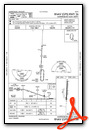
IFR Chart of KMBT
Enroute Charts at SkyVector.com
Location Information for KMBT
Coordinates: N35°52.72' / W86°22.65'Located 02 miles N of Murfreesboro, Tennessee on 225 acres of land. View all Airports in Tennessee.
Surveyed Elevation is 614 feet MSL.
Operations Data
|
|
Airport Communications
| AWOS-3: | 133.975 Tel. 615-849-2622 |
|---|---|
| NASHVILLE APPROACH: | 118.4 360.7 |
| NASHVILLE DEPARTURE: | 118.4 360.7 |
| UNICOM: | 123.075 |
| CTAF: | 123.075 |
| AWOS-3PT at MQY (10.0 NW): | 119.125 615-223-7716 |
| AWOS-3 at M54 (19.1 N): | 118.325 615-444-5778 |
| AWOS-3 at SYI (19.4 S): | 119.275 931-685-4723 |
Nearby Navigation Aids
|
| ||||||||||||||||||||||||||||||||||||||||||||||||||||||||||||


Runway 18/36
| Dimensions: | 4750 x 100 feet / 1448 x 30 meters | |
|---|---|---|
| Surface: | Asphalt in Good Condition | |
| Weight Limits: | S-30 | |
| Edge Lighting: | Medium Intensity | |
| Runway 18 | Runway 36 | |
| Coordinates: | N35°53.11' / W86°22.63' | N35°52.33' / W86°22.67' |
| Elevation: | 598.1 | 613.7 |
| Traffic Pattern: | Left | Left |
| Runway Heading: | 182° True | 2° True |
| Displaced Threshold: | 300 Feet | |
| Markings: | Non-Precision Instrument in good condition. | Non-Precision Instrument in good condition. |
| Glide Slope Indicator | P2L (3.00° Glide Path Angle) | P2L (3.75° Glide Path Angle) |
| REIL: | Yes | Yes |
| Obstacles: | 57 ft Tree 1801 ft from runway, 487 ft left of center | 88 ft Tree 1681 ft from runway, 292 ft left of center |
Services Available
| Fuel: | 100LL (blue), Jet A+ |
|---|---|
| Transient Storage: | Hangars,Tiedowns |
| Airframe Repair: | MAJOR |
| Engine Repair: | MAJOR |
| Bottled Oxygen: | LOW |
| Bulk Oxygen: | LOW |
| Other Services: | AIR FREIGHT SERVICES,AVIONICS,CHARTER SERVICE,PILOT INSTRUCTION,AIRCRAFT RENTAL,AIRCRAFT SALES |
Ownership Information
| Ownership: | Publicly owned | |
|---|---|---|
| Owner: | CITY OF MURFREESBORO | |
| CITY HALL, 111 W VINE ST. | ||
| MURFREESBORO, TN 37130 | ||
| 615-893-5210 | ||
| Manager: | RYAN HULSEY | |
| 1930 MEMORIAL BLVD. | ||
| MURFREESBORO, TN 37129 | ||
| 615-217-5048 | ||
Other Remarks
- STUDENT FLT TRNG 0800-1700.
- GCO AVBL ON FREQ 135.075 THRU NASHVILLE CD. IF UNA FOR CD CTC NASHVILLE APCH 615-695-4522.
- WILDLIFE INVOF ARPT.
- ENGINE RUN-UP CONDUCTED E SIDE OF MAIN RAMP.
- TRNG PAT CLSD 2200-0700 MON-FRI; WKEND & HOL 2200-0800; OTR TIMES PPR - AMGR.
- NOISE ABATEMENT PROC IN EFCT; DEP CMB 2000 FT MSL BFR TURN.
- OPDT PRACTICE APCHS NA.
- CALM WIND RWY.
Weather Minimums

Instrument Approach Procedure (IAP) Charts

Nearby Airports with Instrument Procedures
| ID | Name | Heading / Distance | ||
|---|---|---|---|---|
 |
KMQY | Smyrna Airport | 318° | 10.5 |
|
M54 | Lebanon Municipal Airport | 009° | 18.9 |
|
KSYI | Bomar Field/Shelbyville Municipal Airport | 189° | 19.4 |
|
KBNA | Nashville International Airport | 315° | 20.8 |
|
KRNC | Warren County Memorial Airport | 112° | 28.2 |
|
0A3 | Smithville Municipal Airport | 076° | 28.4 |
|
KXNX | Music City Exec Airport | 357° | 29.8 |
|
KLUG | Ellington Airport | 223° | 30.5 |
|
KTHA | Tullahoma Regional/Wm Northern Field Airport | 167° | 30.5 |
|
KJWN | John C Tune Airport | 306° | 30.8 |
|
3M7 | Lafayette Municipal Airport | 021° | 41.4 |
|
KSRB | Upper Cumberland Regional Airport | 075° | 42.6 |
Airport Images
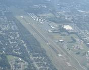
By: Big Orange Bird


