Login
Register


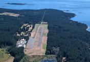
S31
Lopez Island Airport
Official FAA Data Effective 2026-01-22 0901Z
Chart Supplement

VFR Chart of S31
Sectional Charts at SkyVector.com
IFR Chart of S31
Enroute Charts at SkyVector.com
Location Information for S31
Coordinates: N48°29.04' / W122°56.26'Located 03 miles N of Lopez, Washington on 93 acres of land. View all Airports in Washington.
Surveyed Elevation is 208 feet MSL.
Operations Data
|
|
Airport Communications
| AWOS-3P: | 118.525 Tel. 360-376-2071 |
|---|---|
| CTAF: | 128.250 |
| ASOS at FHR (4.1 NW): | 135.675 360-378-8491 |
| AWOS-3P at ORS (13.5 N): | 135.425 360-376-6045 |
| ATIS at NUW (13.7 SE): | 134.15 |
Nearby Navigation Aids
|
| ||||||||||||||||||||||||||||||||||||||||||||||||||||||


Runway 16/34
| Dimensions: | 2905 x 61 feet / 885 x 19 meters | |
|---|---|---|
| Surface: | Asphalt / Grooved in Good Condition | |
| Weight Limits: | S-12 | |
| Edge Lighting: | Medium Intensity TWY MARKED WITH REFLECTORS. | |
| Runway 16 | Runway 34 | |
| Coordinates: | N48°29.27' / W122°56.26' | N48°28.80' / W122°56.26' |
| Elevation: | 208.8 | 162.9 |
| Traffic Pattern: | Right | |
| Markings: | Basic in fair condition. | Basic in fair condition. |
| Glide Slope Indicator | P2L (4.00° Glide Path Angle) | P2L (4.00° Glide Path Angle) |
| REIL: | Yes | Yes |
| Obstacles: | 87 ft Trees 1948 ft from runway | 60 ft Trees 900 ft from runway |
Services Available
| Fuel: | NONE |
|---|---|
| Transient Storage: | Tiedowns |
| Airframe Repair: | NONE |
| Engine Repair: | NONE |
| Bottled Oxygen: | NONE |
| Bulk Oxygen: | NONE |
| Other Services: | AIR FREIGHT SERVICES,CHARTER SERVICE |
Ownership Information
| Ownership: | Publicly owned | |
|---|---|---|
| Owner: | PORT OF LOPEZ | |
| PO BOX 907 | ||
| LOPEZ, WA 98261 | ||
| 360-468-4116 | ||
| Manager: | WIL CATLIN | |
| PO BOX 907 | ||
| LOPEZ, WA 98261 | ||
| 360-468-4116 | ||
Other Remarks
- RY 16/34 SOFT SHOULDERS & THLDS.
- FOR CD CTC WHIDBEY APCH AT 360-257-3310.
Nearby Airports with Instrument Procedures
| ID | Name | Heading / Distance | ||
|---|---|---|---|---|
 |
KFHR | Friday Harbor Airport | 303° | 4.1 |
|
KORS | Orcas Island Airport | 004° | 13.5 |
|
KNUW | Whidbey Island NAS (Ault Field) Airport | 125° | 13.8 |
|
KOKH | Delaurentis Airport | 142° | 17.5 |
|
KBVS | Skagit Regional Airport | 092° | 20.6 |
|
CYYJ | Victoria International Airport | 296° | 21.8 |
|
KBLI | Bellingham International Airport | 040° | 24.4 |
|
0S9 | Jefferson County International Airport | 168° | 26.3 |
|
KNOW | Port Angeles CGAS Airport | 223° | 28.1 |
|
KCLM | William R Fairchild International Airport | 226° | 31.4 |
|
KAWO | Arlington Municipal Airport | 121° | 36.7 |
|
CYXX | Abbotsford Airport | 034° | 39.8 |