Login
Register


BTA
Blair Exec Airport
Official FAA Data Effective 2026-02-19 0901Z
Chart Supplement

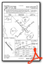
VFR Chart of KBTA
Sectional Charts at SkyVector.com
IFR Chart of KBTA
Enroute Charts at SkyVector.com
Location Information for KBTA
Coordinates: N41°24.89' / W96°6.54'Located 07 miles S of Blair, Nebraska on 306 acres of land. View all Airports in Nebraska.
Surveyed Elevation is 1317 feet MSL.
Operations Data
|
|
Airport Communications
| AWOS-3: | 120.225 Tel. 402-426-0448 |
|---|---|
| OMAHA APPROACH: | 135.875 354.05 |
| OMAHA DEPARTURE: | 135.875 354.05 |
| CTAF: | 123.050 |
| UNICOM: | 123.050 |
| ASOS at OMA (11.2 SE): | 402-271-7515 |
| D-ATIS at OMA (11.8 SE): | 120.4 |
| AWOS-3 at MLE (13.1 S): | 118.25 402-895-6778 |
Nearby Navigation Aids
|
| ||||||||||||||||||||||||||||||||||||||||||||||||||||||||||||


Runway 13/31
| Dimensions: | 4201 x 100 feet / 1280 x 30 meters | |
|---|---|---|
| Surface: | Concrete in Good Condition | |
| Weight Limits: | S-30, D-60 | |
| Edge Lighting: | Medium Intensity | |
| Runway 13 | Runway 31 | |
| Coordinates: | N41°25.14' / W96°6.85' | N41°24.63' / W96°6.23' |
| Elevation: | 1317.6 | 1298.4 |
| Traffic Pattern: | Left | Left |
| Runway Heading: | 137° True | 317° True |
| Markings: | Non-Precision Instrument in good condition. | Non-Precision Instrument in good condition. |
| Glide Slope Indicator | P2L (3.00° Glide Path Angle) | P2L (3.00° Glide Path Angle) |
| REIL: | Yes | |
| Obstacles: | 53 ft Pole 1928 ft from runway, 407 ft right of center | |
Services Available
| Fuel: | 100LL (blue), Jet-A |
|---|---|
| Transient Storage: | Tiedowns |
| Airframe Repair: | NONE |
| Engine Repair: | NONE |
| Bottled Oxygen: | NONE |
| Bulk Oxygen: | NONE |
Ownership Information
| Ownership: | Publicly owned | |
|---|---|---|
| Owner: | BLAIR AIRPORT AUTH | |
| 218 SOUTH 16TH ST | ||
| BLAIR, NE 68008-2000 | ||
| 402-426-4191 | ||
| Manager: | PHIL GREEN | CITY ADMINISTRATOR |
| 218 SOUTH 16TH ST | ||
| BLAIR, NE 68008-2000 | ||
| 402-426-6693 | ||
Other Remarks
- GLIDER ACTIVITY ON & INVOF ARPT.
- FOR NOISE ABATEMENT PROCEDURES CONTACT AMGR ON 402-426-4191.
- FOR CD CTC OMAHA APCH AT 402-682-4395.
- SURVEYED
- 0LL 24 HR SELF SVC FUEL AVBL WITH CREDIT CARD.
- ACTVT MIRL RY 13/31; PAPI RYS 13 & 31, AND REIL RY 31-CTAF.
Weather Minimums


Instrument Approach Procedure (IAP) Charts

Nearby Airports with Instrument Procedures
| ID | Name | Heading / Distance | ||
|---|---|---|---|---|
 |
KOMA | Eppley Airfield Airport | 124° | 11.8 |
|
KMLE | Millard Airport | 180° | 13.1 |
|
KCBF | Council Bluffs Municipal Airport | 120° | 18.4 |
|
KFET | Fremont Municipal Airport | 276° | 18.7 |
|
KOFF | Offutt AFB Airport | 152° | 19.9 |
|
KTQE | Tekamah Municipal Airport | 351° | 21.1 |
|
KAHQ | Wahoo Municipal Airport | 244° | 24.3 |
|
KSCB | Scribner State Airport | 296° | 26.3 |
|
KPMV | Plattsmouth Municipal/Douglas V Duey Field Airport | 162° | 29.3 |
|
KHNR | Harlan Municipal Airport | 073° | 36.1 |
|
KLNK | Lincoln Airport | 221° | 44.9 |
|
KRDK | Red Oak Municipal Airport | 121° | 45.5 |
Airport Images
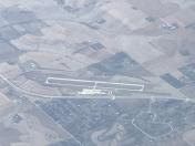
By: Big Orange Bird


