Login
Register


AHQ
Wahoo Municipal Airport
Official FAA Data Effective 2026-02-19 0901Z
Chart Supplement

VFR Chart of KAHQ
Sectional Charts at SkyVector.com
IFR Chart of KAHQ
Enroute Charts at SkyVector.com
Location Information for KAHQ
Coordinates: N41°14.44' / W96°35.67'Located 02 miles NE of Wahoo, Nebraska on 126 acres of land. View all Airports in Nebraska.
Surveyed Elevation is 1225 feet MSL.
Operations Data
|
|
Airport Communications
| AWOS-3P: | 125.975 Tel. 402-443-4030 |
|---|---|
| OMAHA APPROACH: | 135.875 354.05 |
| OMAHA DEPARTURE: | 135.875 354.05 |
| UNICOM: | 122.700 |
| CTAF: | 122.700 |
| AWOS-3 at FET (13.0 N): | 121.275 402-727-9135 |
| AWOS-3 at MLE (21.9 E): | 118.25 402-895-6778 |
| AWOS-3 at BTA (24.3 NE): | 120.225 402-426-0448 |
Nearby Navigation Aids
|
| ||||||||||||||||||||||||||||||||||||||||||||||||||||||||||||


Runway 02/20
| Dimensions: | 4100 x 75 feet / 1250 x 23 meters | |
|---|---|---|
| Surface: | Concrete in Good Condition | |
| Weight Limits: | 10 /R/A/W/T, S-20 | |
| Edge Lighting: | Medium Intensity | |
| Runway 02 | Runway 20 | |
| Coordinates: | N41°14.20' / W96°35.81' | N41°14.82' / W96°35.44' |
| Elevation: | 1221.6 | 1225.5 |
| Traffic Pattern: | Left | Left |
| Runway Heading: | 24° True | 204° True |
| Markings: | Non-Precision Instrument in good condition. | Non-Precision Instrument in good condition. |
| Glide Slope Indicator | P2L (3.00° Glide Path Angle) | P2L (3.00° Glide Path Angle) |
| REIL: | Yes | Yes |
Runway 13/31
| Dimensions: | 3281 x 150 feet / 1000 x 46 meters | |
|---|---|---|
| Surface: | Turf in Fair Condition | |
| Runway 13 | Runway 31 | |
| Coordinates: | N41°14.55' / W96°35.96' | N41°14.13' / W96°35.51' |
| Elevation: | 1223.3 | 1220.9 |
| Traffic Pattern: | Left | Left |
| Runway Heading: | 141° True | 321° True |
Services Available
| Fuel: | 100LL (blue), Jet-A |
|---|---|
| Transient Storage: | Hangars,Tiedowns |
| Airframe Repair: | MAJOR |
| Engine Repair: | MAJOR |
| Bottled Oxygen: | NONE |
| Bulk Oxygen: | NONE |
| Other Services: | CROP DUSTING SERVICES,PILOT INSTRUCTION,ANNUAL SURVEYING |
Ownership Information
| Ownership: | Publicly owned | |
|---|---|---|
| Owner: | WAHOO AIRPORT AUTHORITY | BRIAN HOMES - ARPT AUTH CHAIRMAN. |
| PO BOX 122 | ||
| WAHOO, NE 68066-0122 | ||
| 402-443-3222 | ||
| Manager: | CHRISTINA FASEL | |
| WAHOO, NE 68066-0122 | ||
| 402-443-3222 | ||
Other Remarks
- RY 13/31 NOT PLOWED WINTER MONTHS.
- FOR CD CTC OMAHA APCH AT 402-682-4395.
- 0LL FUEL AVBL H24 SELF SVC.
- ACTVT REIL RWY 02 & 20; PAPI RWY 02 & 20; MIRL 02/20 - CTAF.
Weather Minimums


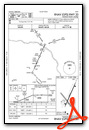
Instrument Approach Procedure (IAP) Charts

Nearby Airports with Instrument Procedures
| ID | Name | Heading / Distance | ||
|---|---|---|---|---|
 |
KFET | Fremont Municipal Airport | 014° | 13.0 |
|
KMLE | Millard Airport | 096° | 22.0 |
|
KSCB | Scribner State Airport | 355° | 22.3 |
|
93Y | David City Municipal Airport | 268° | 23.9 |
|
KBTA | Blair Exec Airport | 064° | 24.3 |
|
KLNK | Lincoln Airport | 197° | 24.5 |
|
KOMA | Eppley Airfield Airport | 083° | 31.9 |
|
KOFF | Offutt AFB Airport | 102° | 31.9 |
|
KSWT | Seward Municipal Airport | 226° | 32.5 |
|
KPMV | Plattsmouth Municipal/Douglas V Duey Field Airport | 119° | 35.4 |
|
KOLU | Columbus Municipal Airport | 290° | 36.0 |
|
KTQE | Tekamah Municipal Airport | 030° | 36.6 |
Airport Images
Do you have a recent image of this airport? Upload it here!


