Login
Register


SGJ
Northeast Florida Regional Airport
Official FAA Data Effective 2025-04-17 0901Z
From the Flight Deck
Chart Supplement

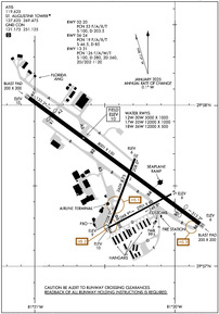
KSGJ Airport Diagram
VFR Chart of KSGJ
Sectional Charts at SkyVector.com
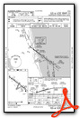
IFR Chart of KSGJ
Enroute Charts at SkyVector.com
Location Information for KSGJ
Coordinates: N29°57.56' / W81°20.38'Located 04 miles N of St Augustine, Florida on 668 acres of land. View all Airports in Florida.
Surveyed Elevation is 9 feet MSL.
Operations Data
|
|
Airport Communications
| ATIS: | 119.625 |
|---|---|
| AWOS-3PT: | 119.625 Tel. 904-824-7084 |
| ST AUGUSTINE TOWER: | 127.625 269.475 |
| ST AUGUSTINE GROUND: | 121.175 251.125 |
| JACKSONVILLE APPROACH: | 120.75 |
| JACKSONVILLE DEPARTURE: | 120.75 |
| CTAF: | 127.625 |
| UNICOM: | 122.950 |
| AWOS-3 at NIP (24.0 NW): | 119.275 |
| ATIS at NIP (24.0 NW): | 290.425 |
| ATIS at CRG (24.4 N): | 125.4 |
Nearby Navigation Aids
|
| ||||||||||||||||||||||||||||||||||||||||||||||||||||||


Runway 17W/35W
| Dimensions: | 12000 x 1000 feet / 3658 x 305 meters | |
|---|---|---|
| Surface: | Water | |
| Runway 17W | Runway 35W | |
Runway 18W/36W
| Dimensions: | 12000 x 500 feet / 3658 x 152 meters | |
|---|---|---|
| Surface: | Water | |
| Runway 18W | Runway 36W | |
Runway 13/31
| Dimensions: | 8001 x 150 feet / 2439 x 46 meters | |
|---|---|---|
| Surface: | Asphalt / Grooved in Good Condition | |
| Weight Limits: | 126/F/A/W/T, S-100, D-280, ST-560, DT-1120 | |
| Edge Lighting: | High Intensity | |
| Runway 13 | Runway 31 | |
| Coordinates: | N29°58.05' / W81°21.04' | N29°57.26' / W81°19.82' |
| Elevation: | 9.5 | 5.7 |
| Traffic Pattern: | Left | Left |
| Runway Heading: | 126° True | 306° True |
| Displaced Threshold: | 1056 Feet | 806 Feet |
| Declared Distances: | TORA:8001 TODA:8001 ASDA:7202 LDA:6144 | TORA:8001 TODA:8001 ASDA:6730 LDA:5925 |
| Markings: | Precision Instrument in fair condition. | Precision Instrument in fair condition. |
| Glide Slope Indicator | V4L (3.00° Glide Path Angle) | P4L (3.00° Glide Path Angle) |
| Approach Lights: | MALSR 1,400 Foot Medium-intensity Approach Lighting System with runway alignment indicator lights. | |
| Centerline Lights: | Yes | Yes |
| Obstacles: | 15 ft Road 200 ft from runway, 150 ft right of center RWY 13 APCH SLP 34:1 TO MKD DSPCD THR. ROAD 15 FT TALL 200 FT BFR AER OF RWY 13 150 RIGHT OF CNTRLN. |
|
Runway 12W/30W
| Dimensions: | 5000 x 1000 feet / 1524 x 305 meters | |
|---|---|---|
| Surface: | Water | |
| Runway 12W | Runway 30W | |
Runway 06/24
| Dimensions: | 2701 x 60 feet / 823 x 18 meters | |
|---|---|---|
| Surface: | Asphalt in Good Condition | |
| Weight Limits: | 19 /F/A/X/T, S-46, D-85 | |
| Edge Lighting: | Medium Intensity | |
| Runway 06 | Runway 24 | |
| Coordinates: | N29°57.24' / W81°20.48' | N29°57.45' / W81°20.03' |
| Elevation: | 9.6 | 5.9 |
| Traffic Pattern: | Left | Left |
| Runway Heading: | 62° True | 242° True |
| Declared Distances: | TORA:2701 TODA:2701 ASDA:2701 LDA:2701 | TORA:2701 TODA:2701 ASDA:2701 LDA:2701 |
| Markings: | Basic in good condition. | Basic in good condition. |
| Glide Slope Indicator | P2L (3.25° Glide Path Angle) | |
| Obstacles: | 53 ft Trees 1055 ft from runway, 145 ft right of center | |
Runway 02/20
| Dimensions: | 2609 x 75 feet / 795 x 23 meters | |
|---|---|---|
| Surface: | Asphalt in Good Condition | |
| Weight Limits: | 53 /F/A/X/T, S-100, D-203 | |
| Edge Lighting: | Medium Intensity | |
| Runway 02 | Runway 20 | |
| Coordinates: | N29°57.27' / W81°20.46' | N29°57.67' / W81°20.29' |
| Elevation: | 9.1 | 5.5 |
| Traffic Pattern: | Left | Left |
| Runway Heading: | 21° True | 201° True |
| Declared Distances: | TORA:2610 TODA:2610 ASDA:2610 LDA:2610 | TORA:2610 TODA:2610 ASDA:2610 LDA:2610 |
| Markings: | Basic in good condition. | Basic in good condition. |
| Obstacles: | 76 ft Trees 1345 ft from runway, 75 ft left of center | |
Services Available
| Fuel: | 100LL (blue), Jet-A |
|---|---|
| Transient Storage: | Hangars,Tiedowns |
| Airframe Repair: | MAJOR |
| Engine Repair: | MAJOR |
| Bottled Oxygen: | HIGH/LOW |
| Bulk Oxygen: | NONE |
| Other Services: | AIR AMBULANCE SERVICES,AVIONICS,CHARTER SERVICE,PILOT INSTRUCTION,AIRCRAFT RENTAL,AIRCRAFT SALES |
Ownership Information
| Ownership: | Publicly owned | |
|---|---|---|
| Owner: | ST AUGUSTINE ARPT AUTH | |
| 4796 US 1 NORTH | ||
| ST AUGUSTINE, FL 32095 | ||
| 904-209-0090 | ||
| Manager: | COURTNEY PITTMAN | |
| 4796 US 1 NORTH | ||
| ST AUGUSTINE, FL 32095 | ||
| 904-209-0090 | ||
Other Remarks
- AEROBATIC ACT E SIDE OF RWY 13/31 CTC TWR FOR TFC & GNV RADIO FOR TIMES.
- FICON NOT MNTD 2100 - 0700 LCL.
- FOR CD IF UNA TO CTC ON FSS FREQ, CTC JACKSONVILLE APCH AT 904-741-0284.
- RWYS 06/24, 02/20, 12W/30W, 17W/35W & 18W/36W NOT AVBL FOR SKED ACR OPNS WITH MORE THAN 9 PAX SEATS OR UNSKED ACR AT LEAST 31 PAX SEATS
- 0LL JET SINGLE POINT REFUELING AVBL.
- SELF SVC FUEL AVBL 24 HRS WITH CREDIT CARD.
- ACTVT MALSR RWY 31; HIRL RWY 13/31; MIRL RWY 06/24 & 2/20 - CTAF. PAPI RWY 06 & 31 AND VASI RWY 13 OPR CONSLY.
- INTL LRA. USER FEE CTC U.S.CUSTOMS ON ARPT 904-209-0099.
Weather Minimums

Standard Terminal Arrival (STAR) Charts

Instrument Approach Procedure (IAP) Charts


Nearby Airports with Instrument Procedures
| ID | Name | Heading / Distance | ||
|---|---|---|---|---|
 |
KNIP | Jacksonville NAS (Towers Field) Airport | 313° | 24.0 |
|
KCRG | Jacksonville Exec At Craig Airport | 338° | 24.3 |
|
28J | Palatka Municipal/Lt Kay Larkin Field Airport | 225° | 25.6 |
|
KNRB | Mayport Ns (Adm David L Mcdonald Field) Airport | 350° | 26.2 |
|
KFIN | Flagler Exec Airport | 166° | 30.4 |
|
KHEG | Herlong Recreational Airport | 308° | 30.9 |
|
KVQQ | Cecil Airport | 299° | 32.0 |
|
KJAX | Jacksonville International Airport | 330° | 36.8 |
|
42J | Keystone Heights Airport | 259° | 37.5 |
|
KFHB | Fernandina Beach Municipal Airport | 350° | 39.6 |
|
KOMN | Ormond Beach Municipal Airport | 163° | 41.1 |
|
KDAB | Daytona Beach International Airport | 162° | 48.9 |


Comments
Helpful
I wanted to stay here overnight but the lack of a car or ride sent me packing. The staff at Atlantic were helpful and the fuel service very fast.
Pages