Login
Register


VQQ
Cecil Airport
Official FAA Data Effective 2026-01-22 0901Z
Chart Supplement

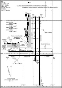
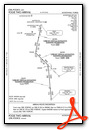
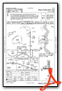
KVQQ Airport Diagram
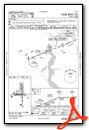
VFR Chart of KVQQ
Sectional Charts at SkyVector.com
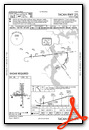
IFR Chart of KVQQ
Enroute Charts at SkyVector.com
Location Information for KVQQ
Coordinates: N30°13.13' / W81°52.63'Located 00 miles N of Jacksonville, Florida on 6082 acres of land. View all Airports in Florida.
Surveyed Elevation is 79 feet MSL.
Operations Data
|
|
Airport Communications
| ATIS: | 125.275 |
|---|---|
| AWOS-3: | 125.275 Tel. 904-778-6934 |
| CECIL TOWER: | 126.1 235.625 |
| CECIL GROUND: | 121.625 226.675 |
| JACKSONVILLE APPROACH: | 127.775 377.075 |
| JACKSONVILLE DEPARTURE: | 127.775 |
| CLEARANCE DELIVERY: | 123.975 254.25 |
| CTAF: | 126.100 |
| ALCRN STAR: | 127.0 269.9 |
| AWOS-3 at HEG (5.1 NE): | 119.275 904-741-2224 |
| ATIS at NIP (10.5 E): | 290.425 |
| AWOS-3 at NIP (10.6 E): | 119.275 |
Nearby Navigation Aids
|
| ||||||||||||||||||||||||||||||||||||||||||||||||||||||


Runway 18L/36R
| Dimensions: | 12504 x 200 feet / 3811 x 61 meters | |
|---|---|---|
| Surface: | Asphalt-Concrete in Good Condition | |
| Weight Limits: | 59 /R/B/W/T | |
| Edge Lighting: | High Intensity | |
| Runway 18L | Runway 36R | |
| Coordinates: | N30°14.10' / W81°52.45' | N30°12.04' / W81°52.43' |
| Elevation: | 79.0 | 71.6 |
| Runway Heading: | 180° True | 360° True |
| Markings: | Precision Instrument in good condition. | Precision Instrument in good condition. |
| Glide Slope Indicator | P4L (3.00° Glide Path Angle) | P4L (3.00° Glide Path Angle) |
| Approach Lights: | MALSR 1,400 Foot Medium-intensity Approach Lighting System with runway alignment indicator lights. | |
| REIL: | Yes | |
| Obstacles: | 74 ft Trees 3125 ft from runway, 320 ft left of center | 87 ft Trees 4595 ft from runway, 500 ft left of center |
Runway 09R/27L
| Dimensions: | 8003 x 200 feet / 2439 x 61 meters | |
|---|---|---|
| Surface: | Asphalt-Concrete in Fair Condition | |
| Weight Limits: | 21 /F/A/X/T | |
| Edge Lighting: | High Intensity | |
| Runway 09R | Runway 27L | |
| Coordinates: | N30°12.94' / W81°53.50' | N30°12.95' / W81°51.98' |
| Elevation: | 76.5 | 63.8 |
| Runway Heading: | 90° True | 270° True |
| Markings: | Precision Instrument in good condition. | Non-Precision Instrument in good condition. |
| Glide Slope Indicator | P4L (3.00° Glide Path Angle) | P4L (3.00° Glide Path Angle) |
| Approach Lights: | MALSR 1,400 Foot Medium-intensity Approach Lighting System with runway alignment indicator lights. | |
| REIL: | Yes | |
| Obstacles: | 76 ft Trees 2860 ft from runway, 225 ft left of center | 50 ft Trees 1920 ft from runway, 550 ft left of center |
Runway 18R/36L
| Dimensions: | 8001 x 200 feet / 2439 x 61 meters | |
|---|---|---|
| Surface: | Asphalt-Concrete in Poor Condition LONGL & TRANSVERSE CRACKING BTN INTS. | |
| Weight Limits: | 21 /F/A/Y/T | |
| Runway 18R | Runway 36L | |
| Coordinates: | N30°14.10' / W81°52.58' | N30°12.78' / W81°52.57' |
| Elevation: | 79.2 | 70.1 |
| Runway Heading: | 179° True | 359° True |
| Markings: | Precision Instrument in fair condition. | Non-Precision Instrument in fair condition. |
| Obstacles: | 79 ft Trees 3840 ft from runway, 225 ft right of center | |
Runway 09L/27R
RSTD TO FIXED WING 12500 LBS & BLW. | ||
| Dimensions: | 4439 x 200 feet / 1353 x 61 meters | |
|---|---|---|
| Surface: | Asphalt-Concrete in Good Condition | |
| Weight Limits: | 27 /R/B/X/T | |
| Runway 09L | Runway 27R | |
| Coordinates: | N30°13.05' / W81°53.50' | N30°13.06' / W81°52.66' |
| Elevation: | 79.5 | 71.3 |
| Runway Heading: | 90° True | 270° True |
| Markings: | Basic in fair condition. | Basic in fair condition. |
| Obstacles: | 74 ft Trees 2720 ft from runway, 275 ft left of center | |
Helipad H1
| Dimensions: | 70 x 70 feet / 21 x 21 meters | |
|---|---|---|
| Surface: | Concrete in Good Condition | |
| Coordinates: | N30°13.12' / W81°53.49' | N0°0.00' / E0°0.00' |
| Elevation: | 77.5 | |
| Markings: | Basic in good condition. | |
Helipad H2
| Dimensions: | 70 x 70 feet / 21 x 21 meters | |
|---|---|---|
| Surface: | Concrete in Good Condition | |
| Coordinates: | N30°13.11' / W81°53.13' | N0°0.00' / E0°0.00' |
| Elevation: | 73.7 | |
| Markings: | Basic in good condition. | |
Services Available
| Fuel: | 100LL (blue), Jet A-1+ |
|---|---|
| Transient Storage: | Tiedowns |
| Airframe Repair: | MAJOR |
| Engine Repair: | MAJOR |
| Bottled Oxygen: | HIGH/LOW |
| Bulk Oxygen: | HIGH |
| Other Services: | AVIONICS,PILOT INSTRUCTION ON CALL. |
Ownership Information
| Ownership: | Publicly owned | |
|---|---|---|
| Owner: | JACKSONVILLE AVIATION AUTHORITY | |
| 14201 PECAN PARK ROAD | ||
| JACKSONVILLE, FL 32218-0018 | ||
| 904-741-2013 | ||
| Manager: | MATT BOCCHINO | |
| 13365 SIMPSON WAY | ||
| JACKSONVILLE, FL 32221-5522 | ||
| 904-573-1601 | ||
Other Remarks
- CTN: DALGT GLDR OPS 6000 FT & BLW; HERLONG RECREATIONAL 5 NM NE.
- ARNG: RAMP ACES PPR - D860-7728 OPTION 5; 1300-2130Z++ MON-FRI EXC HOL.
- WILDLIFE INVOF ARPT.
- HOLD SHRT SIGN RWY 9L/27R & 18R/36L UNLGTD.
- 180 DEG TURN ON ASPH PTNS OF RWY BY P-3 OR LRGR NA.
- MIL CARRIER BREAK NA.
- ARNG: MIL ASSETS PPR - C904-573-2300 EXT 1012/1013/1014; TSNT CTC ARNG OPS - 40.90, 148.825 OR 248.2 BFR ENTRY TO PRK RAMP.
- DEP TURNS PRIOR TO DER WO TWR APVL NA.
- GCO AVBL ON FREQ 135.075 - JACKSONVILLE APCH.
- FOR CD WHEN ATCT CLSD, AND UNA VIA GCO, CTC JACKSONVILLE TRACON AT 904-741-0284.
- VTOL OPNS NOT AUTH.
- RWY 18R/36L RSTD TO ACFT WITH WINGSPAN OF LESS THAN 79 FT, EXCLUDING TXY XG.
- AIR TO FBO COMMUNICATIONS (MILLION AIR) AVBL ON 130.925.
- MISC: BOEING AEROSPACE SUPPORT CENTER AIR OPS MON-FRI 0700-1800, SAT PPR, CLSD SUN; ALL ARR - 904-317-2438/2425; 15 MIN PRIOR TO LNDG - 123.475 OR 264.65.
- TWY C CLSD AT MIL GATE. TWY M CLSD EXC TO MIL ACFT.
- WHEN ATCT CLSD ACTVT MALSR RWY 9R & 36R; REIL RWY 18L & 27L; HIRL RWY 18L/36R, 09R/27L - CTAF.
Weather Minimums

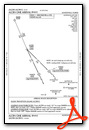
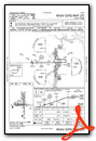
Standard Terminal Arrival (STAR) Charts
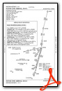

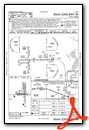
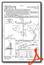
Instrument Approach Procedure (IAP) Charts

Nearby Airports with Instrument Procedures
| ID | Name | Heading / Distance | ||
|---|---|---|---|---|
 |
KHEG | Herlong Recreational Airport | 046° | 5.1 |
|
KNIP | Jacksonville NAS (Towers Field) Airport | 085° | 10.5 |
|
KJAX | Jacksonville International Airport | 030° | 19.2 |
|
KCRG | Jacksonville Exec At Craig Airport | 069° | 20.1 |
|
42J | Keystone Heights Airport | 201° | 24.1 |
|
KNRB | Mayport Ns (Adm David L Mcdonald Field) Airport | 066° | 25.7 |
|
KFHB | Fernandina Beach Municipal Airport | 042° | 31.9 |
|
KSGJ | St Augustine Airport | 118° | 32.0 |
|
28J | Palatka Municipal/Lt Kay Larkin Field Airport | 163° | 35.0 |
|
KLCQ | Lake City Gateway Airport | 266° | 36.4 |
|
KGNV | Gainesville Regional Airport | 213° | 37.7 |
|
09J | Jekyll Island Airport | 024° | 56.3 |
Fuel Providers

Airport Images
")
By: JaxJetport


